New Zealand State Highway 12
| State Highway SH12 in New Zealand | |

|
|
| map | |
| Basic data | |
| Operator: | New Zealand Transport Agency |
| Start of the street: |
Ohaeawai ( 35 ° 21 ′ S , 173 ° 53 ′ E ) |
| End of street: |
Brynderwyn ( 36 ° 6 ′ S , 174 ° 25 ′ E ) |
| Overall length: | 223 km |
|
Regions : |
|
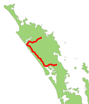
The New Zealand State Highway 12 ( State Highway 12 or SH 12 for short ) is a trunk road of national importance on the North Island of New Zealand .
geography
The trunk road has a length of 223 km and is located in the northern part of the North Island. The road turns south-west of the Bay of Islands and south of Kerikeri in Ohaeawai from New Zealand State Highway 1 through to the west, resulting in a distance from the west coast of the south-east over Dargaville to the Kaipara Harbor and hits northwest of the water at Brynderwyn again the SH 1 .
Routing
From its starting point in Ohaewai, the road leads via Ngawha and Kaikohe to Taheke , from there in a south-westerly direction to Waima , then to shortly after Omanaia in a north-westerly direction. Now the SH 12 turns back to the southwest and runs along the southern foothills of the Hokianga Harbor via Oue , Whirinaki , Motutoa , Pakanae and Opononi to Omapere near the mouth of the Hokianga in the Tasman Sea . Now the road runs for 86 km about five to ten kilometers from the coast to the south. After she has passed Waiotemaramara and Waimamaku and crossed the Waimamaku River , she crosses the Waipoua Forrest with the huge Kauri tree Tane Mahuta . After the forest it reaches Katui and continues along the Kaihu River via Aranga , Kaihu , Ahikiwi , Maropiu and Mamaranui to its confluence with the Wairoa River . Here the SH 12 turns 90 ° to the northwest and reaches the city of Dargaville . State Highway 14 connects it there in a north-easterly direction with SH 1 . The SH 12 , on the other hand, follows the east bank of the Wairoa from Dargaville in a south-south-east direction via Tokatoka , Naumai and Raupo to Ruwai . From here the highway runs east via Paparoa , Huarau and Maungaturoto to Brynderwyn, where it meets the SH 1 again.
Individual evidence
- ^ A b New Zealand Touring Atlas . 5th edition. Hema Maps , Brisbane 2015, ISBN 978-1-907302-92-3 , pp. Map 3–5 (English).

