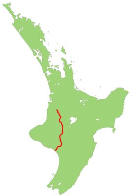
New Zealand State Highway 4
| State Highway SH4 in New Zealand | |

|
|
| map | |
| Basic data | |
| Operator: | New Zealand Transport Agency |
| Start of the street: |
Eight Mile Junction ( 38 ° 25 ′ S , 175 ° 7 ′ E ) |
| End of street: |
Wanganui ( 39 ° 57 ′ S , 175 ° 3 ′ E ) |
| Overall length: | 237 km |
|
Regions : |
|
The New Zealand State Highway 4 ( State Highway 4 or SH 4 for short ) is a trunk road of national importance on the North Island of New Zealand .
geography
The trunk road has a length of 237 km, making it the shortest of the former eight national state highways . The road runs in a north-south direction through the hill country in the interior and forms a shortcut between the two junctions of State Highway 3 about 9 km southwest of Te Kuiti and directly east of Wanganui . State Highway 3 runs along the coast through the Taranaki region between the two connections . The kilometers run from north to south.
route
The road branches off in Eight Mile Junction eleven kilometers south of Te Kuiti , from State Highway 3 from. The road runs in a south-southeast direction, ascending first and then descending again through the winding valleys of the Ohura and Ongarue Rivers , two tributaries of the Whanganui River . The Ongarue flows into the Whanganui near Taumarunui , from there the road turns shortly to the east and follows the Whanganui valley upstream. Now the highway turns to the south and grazes the edge of Mount Ruapehu , whose volcanic peaks are clearly visible from SH 4 , especially the southernmost peak.
In Horopito , the road swings briefly to the southwest to follow a tributary of the Maungawhero River to its mouth near Raetihi . The highway continues along the Maungawhero valley until 40 km before its mouth. From there it runs west through hill country to the valley of the Whanganui River , which it follows for the last 15 km to Wanganui .
Important junctions
| District | place | km | Connection after | Remarks |
|---|---|---|---|---|
| Waitomo District | Eight Mile Junction | 0 |
Hamilton |
SH 4 begins |
|
New Plymouth |
||||
| Ruapehu District | Taumarunui | 70 |
( Kururau Road ) Stratford |
|
| Whanganui River | ||||
| Manunui | 77 |
Turangi |
||
| National Park | 114 |
Turangi |
||
| Tohunga Junction | 140 |
Ohakune , Waiouru |
||
| Whanganui District | Putiki | 237 |
Wanganui , New Plymouth |
SH 4 ends |
|
Palmerston North |
Individual evidence
- ↑ a b c New Zealand Touring Atlas . 5th edition. Hema Maps , Brisbane 2015, ISBN 978-1-907302-92-3 , pp. Map 18, 26 (English).

