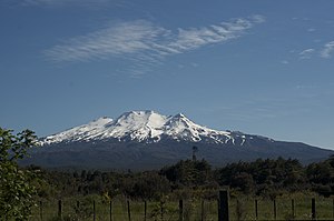
Ruapehu
| Ruapehu | ||
|---|---|---|
| height | 2797 m | |
| location | Ruapehu District , Manawatu-Wanganui , North Island , New Zealand | |
| Mountains | Volcanic plateau | |
| Coordinates | 39 ° 17 '22 " S , 175 ° 33' 45" E | |
|
|
||
| Type | Stratovolcano | |
| Last eruption | September 25, 2007 | |
| First ascent | 1879 G. Beetham and JP Maxwell | |
| Normal way | Hike | |
|
Lahar canals after the mudslide on March 18, 2007 |
||
At 2797 m, Mount Ruapehu is New Zealand's highest volcano and the highest point on the North Island . It stands in the island's Volcanic Plateau and is part of the Tongariro National Park .
There are seven small glaciers on the slopes of Ruapehu . Its crater conceals a crater lake , the contents of which fell into the valley in March 2007 as a mudslide ( lahar ).
Volcanic activity
Of the three neighboring volcanoes of the national park ( Ngauruhoe , Tongariro ), Ruapehu is the one with the most recent activity. The worst impact was a mudslide on December 24, 1953, when a railway bridge collapsed when a train crossed it. 151 people were killed in the Tangiwai railway accident .
Major eruptions took place in 1895, 1945, 1969, 1971, 1975, 1988, September 1995, and June 1996. Although these outbreaks were estimated to be the most violent since the European colonization of New Zealand, no one was injured.
The most recent eruption took place on September 25, 2007: it began without warning and was accompanied by a seven-minute earthquake. The eruption column of gases and ashes reached a height of 5000 meters. The ski area, which was active at that time, and numerous accommodations had to be vacated. A mountain hiker was seriously injured when a boulder hit the roof of a shelter.
Ski areas
Three of New Zealand's four ski areas are located on the slopes of Ruapehu on the North Island.
- Whakapapa Ski Field (16 lifts). This was built from 1952 by the Swiss Walter Haensli on behalf of the New Zealand government.
- Turoa ski field (11 lifts)
- Tukino skifield (2 cables)
The mountain can be reached from Ohakune via a road that ends at the foot of a ski area at an altitude of 1600 m.
Others
On March 18, 2007, after days of heavy rainfall, the edge of the volcanic crater lake burst, causing a tidal wave with thousands of tons of water, mud and debris to break away. The water masses fell from 2500 meters into the valley of the Whangaehu River and past the village of Tangiwai . The waves, up to four meters high, knocked down numerous trees. The authorities had already blocked roads and the nearby railway line in advance . No people were reportedly harmed. Only the memorial for the victims of the railway accident of 1953 was damaged, which was triggered by such a tidal wave.
The Ruapehu was in the third part of the film adaptation of the novel Lord of the Rings by JRR Tolkien the setting for the novel land Mordor .
Panoramic photo
Web links
- Ruapehu in the Global Volcanism Program of the Smithsonian Institution (English)
- Ascent to the Ruapehu
Individual evidence
- ↑ "Ruapehu erupts; climber injured" (English), Dominion Post, September 26, 2007
- ↑ Formation of RAL . Mt Ruapehu - Whakapapa & Turoa New Zealand , archived from the original on November 15, 2008 ; accessed on December 14, 2018 (English, original website no longer available).
- ↑ A ruptured volcanic crater triggered a tidal wave. In: faz.net. March 18, 2007, accessed December 11, 2014 .


