
New Zealand State Highway 43
| State Highway SH43 in New Zealand | |
| Forgotten World Highway | |

|
|
| map | |
 |
|
| Basic data | |
| Operator: | New Zealand Transport Agency |
| Start of the street: |
Stratford ( 39 ° 20 ′ S , 174 ° 17 ′ E ) |
| End of street: |
Taumarunui ( 38 ° 53 ′ S , 175 ° 15 ′ E ) |
| Overall length: | 155 km |
|
Regions : |
|
 |
|
| The SH 43 is unpaved over a length of eleven kilometers. | |
The New Zealand State Highway 43 ( State Highway 43 or SH 43 for short , also known as Forgotten World Highway ) is a national highway on the North Island of New Zealand . The road is considered the first Heritage Highway (mutatis mutandis: Heritage Street ) in the country.
Origin of name
The name " Forgotten World Highway " results from the remote location of the road in a largely untouched area and the decentralized location to the administrative centers, whose headquarters are the two endpoints for the respective districts. Due to its numerous references to the history of the region, the interesting diverse landscape and numerous geological features, this road has a special charm, especially for tourists.
geography
The trunk road has a length of 155 km and is located in the western part of the North Island. It connects the places Taumarunui in the Ruapehu District of the Manawatu-Wanganui region and Stratford in the Stratford District of the Taranaki region .
With an average of 150 vehicles per day, New Zealand's highway has the lowest traffic. It takes around three hours to get there by car, and one hour more with a campervan. The highway winds over four mountain saddles, through a single-lane tunnel and along a river valley shaped by many bends. About eleven kilometers of the route are unpaved. A gravel road there requires careful driving behavior.
Routing
- Km 0: Taumarunui (junction from SH4 )
- Km 10: Te Maire
- Km 25: Aukopae
- Km 42: junction to Stratford (SH 43 and Ohura )
- Km 47: Tatu
- Km 63: Tangarakau Gorge
- Km 73: Tahora
- Km 80: Kohuratahi
- Km 90: Whangamomona
- Km 98: Pohokura
- Km 109: Te Wera
- Km 116: Huikama
- Km 119: Strathmore
- Km 132: Douglas
- Km 145: Toko
- Km 155: Stratford
Except for Whangamomona, these places or place names are settlements of fewer people or earlier places of settlement or economic use.
Attractions
A selection of the sights and peculiarities along the route, other places worth seeing are partly a few kilometers off the Forgotten World Highway:
- Taumarunui has a long tradition among the Māori , and numerous larger gatherings have taken place here. Today the city has a railway station on the main line Auckland - Wellington .
- Te Maire Reserve , large contiguous stone stone forest area with hiking trails
- Nukunuku Museum , with exhibits from the first settlers
- Aukopae Tunnel , former road tunnel, not used since 1968
- Nevins Lookout , lookout point with a view of the volcanoes
- The Tangarakau Gorge , Steineiben Primeval Forest
- Morgan's Grave , grave of early explorer of the area, Joshua Morgan , who died here in 1892 at the age of 35 of an illness
- Moki Tunnel , 180 meter long single lane tunnel built in 1936, during the construction of which numerous fossils were found. Today the name Hobbits Hole stands above the tunnel portal
- Tahora Saddle , viewpoint over the region and on two railway tunnels
- Whangamomona , the place is known for its historic hotel and for the fact that the Republic of Whangamomona is proclaimed every year in mid-January .
- Whangamomona Saddle , Pohokura Saddle , Strathmore Saddle : mountain saddles with a view over the hill country, from the top of the "Strathmore Saddle" you can see the three volcanoes of the Tongariro National Park , Ruapehu , Tongariro and Ngauruhoe and to the west Mount Taranaki .
Numerous signs of former settlements and farm areas along the road testify to earlier attempts at settlement and economic use of the wild hill country.
Near the village of Strathmore, a road branches off into a remote valley, where the first settlers settled around 1900. Here, in memory of the Bridge to Nowhere in Whanganui National Park, the structurally identical Bridge to Somewhere (Bridge to Somewhere) was created.

Landscape on the Forgotten World Highway

Abandoned building on Forgotten World Highway

Mount Taranki as seen from the Forgotten World Highway
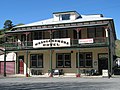
Hotel in Whangamomona

Moki tunnel, also called Hobbits Hole


Web links
- New Zealand Travel - Forgotten World Highway
- Taranaki Region - Forgotten World Highway
- Forgotten World Highway ( Memento from April 12, 2010 in the Internet Archive )
Individual evidence
- ^ A b New Zealand Touring Atlas . 5th edition. Hema Maps , Brisbane 2015, ISBN 978-1-907302-92-3 , pp. Map 17, 18, 25 (English).
| transnational state highways |

|
|
|---|---|---|
| State Highways on the North Island |
SH 1B • SH 2 • SH 3 • SH 3A • SH 4 • SH 5 • SH 10 • SH 11 • SH 12 • SH 14 • SH 15 • SH 15A • SH 16 • SH 17 • SH 18 • SH 20 • SH 20A • SH 20B • SH 21 • SH 22 • SH 23 • SH 24 • SH 25 • SH 25A • SH 26 • SH 27 • SH 28 • SH 29 • SH 30 • SH 30A • SH 31 • SH 32 • SH 33 • SH 34 • SH 35 • SH 36 • SH 37 • SH 38 • SH 39 • SH 40 • SH 41 • SH 43 • SH 44 • SH 45 • SH 46 • SH 47 • SH 48 • SH 49 • SH 49A • SH 50 • SH 52 • SH 53 • SH 54 • SH 56 • SH 57 • SH 57A • SH 58 • SH 59 |
|
| State Highways on the South Island |
SH 6 • SH 6A • SH 7 • SH 7A • SH 8 • SH 8A • SH 8B • SH 9 • SH 60 • SH 61 • SH 63 • SH 65 • SH 67 • SH 69 • SH 70 • SH 71 • SH 73 • SH 73A • SH 74 • SH 74A • SH 75 • SH 77 • SH 79 • SH 80 • SH 82 • SH 83 • SH 84 • SH 85 • SH 86 • SH 87 • SH 88 • SH 90 • SH 94 • SH 95 • SH 96 • SH 98 • SH 99 |