New Zealand State Highway 63
| State Highway SH63 in New Zealand | |

|
|
| map | |
| Basic data | |
| Operator: | New Zealand Transport Agency |
| Start of the street: |
Renwick ( 41 ° 31 ′ S , 173 ° 50 ′ E ) |
| End of street: |
Kawatiri ( 41 ° 42 ' S , 172 ° 37' O ) |
| Overall length: | 117 km |
|
Regions : |
|
| Kawatiri Junction on State Highway 6 | |
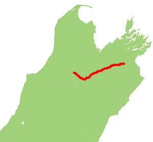
The New Zealand State Highway 63 ( State Highway 63 or SH 63 for short ) is a national highway on the South Island of New Zealand .
geography
The trunk road has a length of 117 km and is located in the north of the South Island. The two-lane road over its entire length (one in each direction of travel) connects State Highway 6 between the Kawatiri junction in the west and its junction at Renwick , 10 km before Blenheim in the east. The SH 63 is an abbreviation for SH 6 , which comes from Blenheim via Havelock in the north and Nelson in the north-west. The SH 63 runs through the two regions of Marlborough and Tasman on its way .
Routing
The State Highway 63 branches off south-east of the small town of Renwick on State Highway 6 west and follow about 81 km to 11 km before Saint Arnaud the course of the Wairau River , beginning on the right, later on the left side of the river. At Saint Arnaud , where the road swings to the northwest, it touches Lake Rotoiti on its north side. From the exit of the village, the SH 63 follows its last 25 km to the Kawatiri junction , where it meets the SH 6 again, then the course of the Buller River . The only noteworthy junction on the entire route of the SH 63 is the one to the Korere Tophouse Road , which branches off to the north 5 km before Saint Arnaud .
Individual evidence
- ^ A b New Zealand Touring Atlas . 5th edition. Hema Maps , Brisbane 2015, ISBN 978-1-877302-92-3 , pp. Map 42, 43, 44 (English).


