New Zealand State Highway 65
| State Highway SH65 in New Zealand | |

|
|
| map | |
| Basic data | |
| Operator: | New Zealand Transport Agency |
| Start of the street: |
O'Sullivans Bridge ( 41 ° 47 ′ S , 172 ° 13 ′ E ) |
| End of street: |
Springs Junction ( 42 ° 20 ′ S , 172 ° 11 ′ E ) |
| Overall length: | 71 km |
|
Regions : |
|
| Development condition: | 2 x 1 lane |
|
Springs Junction State Highway 7 (center) State Highway 65 (right) |
|
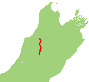
The New Zealand State Highway 65 ( State Highway 65 or SH 65 for short ) is a trunk road of national importance on the South Island of New Zealand .
geography
The trunk road has a length of 71 km and is located in the northwestern part of the South Island. The two-lane road over its entire length (one in each direction of travel) connects State Highway 6 west of Murchison and State Highway 7 near Springs Junction and runs in its northern quarter and its southern half in the valley of the Maruia River . The only in 1929 by an earthquake caused Maruia Falls are located 23 kilometers by road and 9.5 km southwest of Murchison , directly from SH 65 to reach out.
Routing
The State Highway 67 begins 10.5 km west of Murchison , in the valley of the Buller River in O'Sullivan's Bridge and simultaneous branch from State Highway 6 , from which the road in the valley of Maruia River a southerly direction follows. After 10.6 km from a parking lot on the right side of the river, the Maruia Falls can be visited. After another 16.3 km the road leaves the valley of the river, bypassing the 1315 m high Mount Rutland on its east side and meets the Warwick River at the small settlement Burnbrae . This is followed by the SH 65 until the river flows into the Maruia River around 6 km south-southwest of Burnbrae . Back in the valley of the Maruia River , the SH 65 continues its southern course through the valley, changes to the western side of the river around 4 km before Springs Junction and ends at Springs Junction through the connection to State Highway 7 .
The small, scattered settlements of Ariki , Glengarry , Shenandoah , Minehaha , Paenga , Burnbrae and Warwick Junction are distributed from north to south on the route of the SH 65 .
Individual evidence
- ↑ a b c New Zealand Touring Atlas . 5th edition. Hema Maps , Brisbane 2015, ISBN 978-1-877302-92-3 , pp. Map 42, 46 (English).
- ↑ Maruia Falls Track . Department of Conservation , accessed April 15, 2020 .


