New Plymouth
| New Plymouth | ||
| Geographical location | ||
|
|
||
| Coordinates | 39 ° 3 ′ S , 174 ° 5 ′ E | |
| Region ISO | NZ-TKI | |
| Country |
|
|
| region | Taranaki | |
| District | New Plymouth District | |
| Ward | New Plymouth City Ward | |
| Administrative headquarters | Seat of the administration for the New Plymouth District | |
| Residents | 43 987 (2013) | |
| height | 10 m | |
| Post Code | 4310, 4312 | |
| Telephone code | +64 (0) 6 | |
| UN / LOCODE | NZ NPL | |
New Plymouth is a city in the New Plymouth District of the Taranaki regionon the North Island of New Zealand . It is the largest city in the region and also the seat of the New Plymouth District Council .
geography
The city is located around 27 kilometers north of the summit of the 2518 m high Mount Taranaki , a dormant volcano on the west coast of the North Island. The next largest cities are around 130 km away with Wanganui in the southeast and Hamilton in the northeast with around 175 km.
history
The land on which New Plymouth was founded in 1841 was previously home to various Māori tribes . The first Europeans to come to the coast were whalers. In 1840, the first non-native settlers, mainly from England, Poland, Switzerland, the Netherlands, China and India, disembarked from the ship " William Bryant ". At first it was easy for the new settlers to acquire land. The increased demand for new land later led to a conflict with the Māori tribes, who were no longer willing to sell their land and were therefore expropriated. This conflict was the trigger for two of the New Zealand Wars in Taranaki , which lasted ten years and led to great losses among the Māori , as they were far inferior to the British soldiers.
population
For the 2013 census, the city, which can be equated with the area of the New Plymouth City Ward (Wards = political division of the district), had 43,987 inhabitants.
economy
New Plymouth is the service center for the northern region of Taranaki , which is characterized by agriculture and largely lives from the dairy industry. In addition to tourism, the energy sector is also important for the city. Just offshore are some of the largest oil and gas reserves in the country. One of the city's power stations is powered by gas from the Kapuni and Maui fields. The Taranaki Savings Bank (TSB) is based in New Plymouth and contributes to the economic performance of the city.
Infrastructure
Road traffic
The New Zealand State Highway 3 coming from the south of Stratford and the New Zealand State Highway 45 coming from the west , which ends in the city on State Highway 3 , pass through New Plymouth .
Rail transport
In New Plymouth ends Marton-New Plymouth Line , which Stratford , Hawera , Wanganui in Marton to the North Iceland Main Trunk Railway connected.
media
The city's only daily newspaper is the Taranaki Daily News .
Attractions
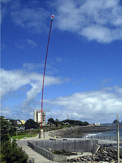
In New Plymouth there is a botanical garden and a - at least at the time of its erection - rather controversial 45 m high sculpture by Len Lye , called the Wind Wand (wind stick). With the Govett Brewster Art Gallery, the city has the most important collection of contemporary art in all of Australasia .
Personalities
- Hannah Bromley (* 1986), soccer player
- Wayne Hildred (* 1955), racing cyclist
- Stan Hill (1927-2019), rugby union player
- Melanie Lynskey (born 1977), actress
- Anthony McCarten (born 1961), writer
- Ajeet Rai (* 1999), tennis player
- Maryan Street (born 1955), politician
See also
literature
- Helga Neubauer: New Plymouth . In: The New Zealand Book . 1st edition. NZ Visitor Publications , Nelson 2003, ISBN 1-877339-00-8 , pp. 436-441 .
Web links
- Homepage . New Plymouth District Council,accessed December 25, 2015.
Individual evidence
- ↑ a b 2013 Census QuickStats about a place: New Plymouth District . Statistics New Zealand , accessed on August 16, 2017 (English, StatsMap: Meshblock analysis from the interactive map from the base of the New Plymouth City Ward ).
- ↑ Topo250 maps . Land Information New Zealand , accessed August 16, 2017 .
- ^ Neubauer: New Plymouth . In: The New Zealand Book . 2003, p. 436 .


