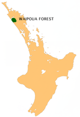
Waipoua Forest
The Waipoua Forest is a forest in the Northland region of the North Island of New Zealand . Three quarters of New Zealand's Kauri trees that have been preserved grow in the 25 km² area . Two of the largest living trees of the species, Tāne Mahuta and Te Matua Ngahere , are particularly well known .
The forest is connected to the neighboring forests of Waima Forest and Mataraua Forests .
The reserve has the largest populations of North Island striped kiwi in Northland. The endangered ragged crows or cocoa ( Callaeas cinerea ) also live on the high plateau .
history
The forest, then about 80 km², was bought by the Maori in 1876 for little more than 2000 pounds.
In 1885 it was placed under protection under the State Forests Act as a State Forest Reserve with an area of 90 km² . One of the reasons this forest escaped deforestation in the early years of European settlement was its remote location and the difficulty of hauling the wood away from there.
In 1907 the Waipoua Forest and one or two smaller sanctuaries were the only original state-owned kauri forest. A Royal Forestry Commission recommended in 1913 that 0.8 km² of the Waipoua Forest and the entire Warawara Forest with 50 km² as National Kauri Forests for the New Zealanders.
In 1926 a road was struck through the Waipoua Forest to provide access to neighboring settlers.
In the 1940s, it became known that the State Forest Service in Waipoua felled kauri trees. In 1947 the Whangarei Progressive Society, together with the Royal Forest and Bird Protection Society , the Waipoua Preservation Society and organizations interested in protecting the area, gave Parliament 50,000 signatures in a wheelbarrow. Their hope was that 160 km² near Waipoua should be protected as a total reserve . Other petitions followed, so that on July 2, 1952, an area of more than 80 km² was designated as a protected area.
2007 fire
At the beginning of 2007 a forest fire threatened the Waipoua Forest. The fire broke out on February 1 after someone cooked clams on an open fire on the nearby coast. The fire destroyed pine plantations in the vicinity of the national park and destroyed the vegetation in ecologically important wetlands. It approached the Tāne Mahuta within 3 km . New Zealand firefighters and Department of Conservation volunteers managed to control the fire by dropping water from helicopters and fire alleys. Multi-million dollar pine forest and numerous protected birds have been lost. Among them were an estimated 20 kiwis . In total, more than 2 km² of vegetation was destroyed.
Web links
- Waipoua Forest . Department of Conservation ,accessed January 12, 2016.
Individual evidence
- ^ Reed, Alfred: The Story of the Kauri . AH and AW Reed. 1953, pp. 267-269.
- ↑ Firefighters work to contain forest blaze February 2, 2007
Coordinates: 35 ° 39 ′ 0 ″ S , 173 ° 33 ′ 0 ″ E

