Greymouth
|
Greymouth Māori: Māwhera |
||
| Geographical location | ||
|
|
||
| Coordinates | 42 ° 27 ′ S , 171 ° 13 ′ E | |
| Region ISO | NZ-WTC | |
| Country |
|
|
| region | West coast | |
| District | Gray District | |
| Ward | Gray Ward | |
| Administrative headquarters | Administrative headquarters for the Gray District | |
| Residents | 5 997 (2013) | |
| height | Height of sea level | |
| Post Code | 7802, 7805 | |
| Telephone code | +64 (0) 3 | |
| UN / LOCODE | NZ GMN | |
| Photography of the place | ||
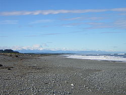
 View of Greymouth |
||

Greymouth ( Te Reo Māori : Māwhera ) is the largest city in the West Coast regionon the South Island of New Zealand . The city is also the administrative seat of the Gray District and the West Coast region.
Origin of name
The name of the city is derived from the Gray River and the English word mouth for "estuary" and means the mouth of the Gray River .
geography
The city is located 85 km southwest of Westport and 36 km northeast of Hokitika directly at the mouth of the Gray River in the Tasman Sea . The city lies on a narrow stretch of coast at the foot of the New Zealand Alps . On a clear day, Aoraki / Mount Cook , New Zealand's highest mountain , can be seen from Greymouth in the south. The mouth of the Gray River divides the city into three districts: Blaketown , near the mouth in the south, Karoro in the southeast, which is separated from Blaketown by a couple of lakes, and Cobden , a formerly independent town on the north bank of the river.
history
Before European settlers came to Greymouth , the Māori had lived in the area for some time. They called the place Māwhera , today another name for the Gray River and at the same time the Māori name of the city of Greymouth . The first European to visit the area was Thomas Brunner in 1846 . He discovered coal in the valley of the river. His name was the inspiration for the city of Brunner and Lake Brunner . Brunner named the river after the prominent New Zealand politician Sir George Edward Gray .
Tornadoes
Greymouth is a place where tornadoes are not uncommon in extreme weather conditions . After the city was hit by tornadoes on March 28, 2001 and June 16, 2003, the tornado of March 10, 2005 caused severe damage to some buildings and injured a few people.
Mining accidents
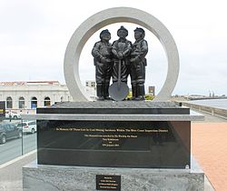
Greymouth has had two major mining accidents so far . On January 18, 1967, 19 miners died in an explosion in the Strongman pit . On November 19, 2010, 29 miners were killed when two explosions occurred at the Pike River mine .
population
In the 2013 census, the town had 5,997 inhabitants, 4.7% less than in the 2006 census.
economy
Greymouth was known for its coal and gold mines. When gold mining stopped, forestry became an important industry in the region. In recent years, attempts Greymouth , ecotourism build a new economy with such. B. in Shantytown Heritage Park , an open air museum with the Infants Creek Tram line .
Greymouth is home to the well-known Monteith's Brewing Co. Limited and the engineering company Dispatch & Garlick, who now specialize in dairy machines and water and sewage systems .
Infrastructure
traffic
Greymouth is on New Zealand State Highway 6 , which runs along the west coast and connects Greymouth with Hokitika in the south and Westport in the north. In addition, two highways branch off from it, which cross the New Zealand Alps and connect the city with the east coast. On the one hand begins in Greymouth of State Highway 7 which, after overcoming the pass Lewis in the region Canterbury to the State Highway 1 applies. Secondly, something turns south at Mukara Junction of State Highway 73 from that over the Arthur's Pass until after Christchurch runs.
Rail transport
The city is also the head end of the Midland Line , on which the TranzAlpine runs between Christchurch and Greymouth .
media
The city's only daily newspaper is the Greymouth Star .
Personalities
- Thomas Peter McKeefry (1899–1973), Archbishop of Wellington
- Bill Pearson (1922–2002), writer and literary critic
- Sharlotte Lucas (* 1992), racing cyclist
See also
Web links
Individual evidence
-
↑ a b
Population figures for the individual districts summarized:
- 2013 Census QuickStats about a place: Cobden . Statistics New Zealand,accessed June 6, 2017.
- 2013 Census QuickStats about a place: Blaketown . Statistics New Zealand,accessed June 6, 2017.
- 2013 Census QuickStats about a place: Greymouth Central . Statistics New Zealand,accessed June 6, 2017.
- 2013 Census QuickStats about a place: Greymouth South . Statistics New Zealand,accessed June 6, 2017.
- ↑ Widespread damage after Greymouth tornado . In: New Zealand Herald . NZME. Publishing Limited , March 10, 2005, accessed June 6, 2017 .
- ↑ Strongman mine explosion . Christchurch City Libraries , January 19, 1967; accessed June 6, 2017 .
- ^ Pike River: Second explosion, no survivors . In: Newshub . MediaWorks TV , November 24, 2010, accessed June 6, 2017 .


