
Arthur's Pass
| Arthur's Pass | |||
|---|---|---|---|
 The Arthur's Pass from the rise of Avalanche Peak |
|||
| Pass height | 920 m | ||
| region | West coast | Canterbury | |
| Watershed | Otira River → Taramakau River | Bealey River → Waimakariri River | |
| Valley locations | Aickens | Bealey track | |
| expansion | Pass road | ||
| map | |||
|
|||
| Coordinates | 42 ° 54 '11 " S , 171 ° 33' 42" E | ||

The Arthur's Pass is an alpine transition to the Southern Alps on the South Island of New Zealand .
geography
The pass is located around 62 km southeast of Greymouth and around 54 km southeast of Hokitika , between Goldney Ridge , which rises up to 1832 m on the west side and the 1913 m high Mount Temple and 1850 m high Mount Cassidy on the east side.
At an altitude of 920 m , Arthur's Pass marks the border between the West Coast on the west side of the South Island and Canterbury on the east side, where Christchurch is around 140 km away. The pass separates the valleys of the Otira River , a tributary of the Taramakau River to the west and the Bealey River to the east.
The pass can be reached via the New Zealand State Highway 73 , which leads from Christchurch over the pass to the west coast and meets the New Zealand State Highway 6 at the Traramakau River , via which the places Greymouth and Hokitika can be reached.
The State Highway 73 is the 942 m high Porters Pass , the highest of the three mountain passes that cross the Southern Alps, followed by the New Zealand State Highway 7 , of the 907 m high Lewis Pass km 90 north-east are crossing and the New Zealand State Highway 6 , which overcomes the 562 m high Haast Pass around 220 km southwest.
history
The pass was named after Arthur Dudley Dobson , who led the first Europeans over the pass in 1864. He knew about the transition, which was occasionally used by local hunters, by tales of the West Coast coming Māori -Häuptlings Tarapuhi . It is further believed that the author and explorer Samuel Butler saw the pass several years earlier but was unable to explore it. The timing of the discovery was favorable because gold was found a little later on the west coast and easy access to the coast of the Tasman Sea was required.
The west rise following the valley of the Otira River was previously notorious for its landslides and avalanches. Extensive expansion work was carried out here in the late 1990s. Worth mentioning is the Otira Viaduct , which was completed in 1999 , near the Otira settlement and spans 440 m of unsafe terrain. Due to the narrowness of the valley, it was necessary to build the viaduct with an exceptionally high gradient of 12% to 16% (European standard for roads prone to frost: 6–8%).
Railway connection
Since 1923, the New Zealand Railway 's Midland Line has run through the mountain at Arthur's Pass using the 8.5 km long Otira Tunnel under the pass. The line is the only railway line that crosses the New Zealand Alps.
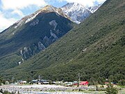
Arthur's Pass village
Arthur's Pass is a small village about 5 km south of the pass. The village is the starting point for hikes in Arthur's Pass National Park .
Photo gallery

Otira Viaduct

TranzAlpine at Arthur's Pass
Arthur's Pass Village


Individual evidence
- ↑ a b c d Topo maps . Land Information New Zealand , accessed July 15, 2018 .
- ↑ Suzanne Starky : Dobson, Arthur Dudley and Dobson, Edward . In: Dictionary of New Zealand Biography . Volume I . Allen & Unwin , Wellington 1990 (English, online [accessed July 15, 2018]).
- ^ Ian J. Billings, J. Holyoake : The Otira Viaduct design and construction . In: The Structural Engineer . Volume 80, Issue 2 , 2002 (English).