
Haast Pass
| Haast Pass | |||
|---|---|---|---|
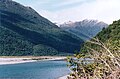
 View of the Haast River and the road to Haast Pass |
|||
| Compass direction | North | south | |
| Pass height | 563 m | ||
| South Island (New Zealand) | |||
| Watershed | Haast River | Makarora River | |
| Valley locations | Haast | Makarora | |
| expansion | New Zealand State Highway 6 | ||
| Mountains | New Zealand Alps | ||
| Map (New Zealand) | |||
|
|||
| Coordinates | 44 ° 6 ′ 19 ″ S , 169 ° 21 ′ 22 ″ E | ||

The Haast Pass is the southernmost and, at just 563 m above sea level, the deepest pass road over the Southern Alps in New Zealand ( Arthur's Pass : 924 m, Lewis Pass : 907 m). It is named after Julius von Haast , who was the first European to conquer it.
geography
The Haast Pass connects the village of Haast on the west coast with Wanaka in Otago via State Highway 6 . The road initially leads along the Haast River with the famous Gates of Haast. The bridge over the Haast River is New Zealand's longest single-lane bridge. Just before the apex, the road passes Fantail Falls. After crossing the top of the pass in front of Makarora, the road leads past the northern end of Lake Wanaka and Lake Hāwea to Wanaka.
As part of the main route from the Franz Josef Glacier to the center of New Zealand, tourists almost inevitably cross this pass.
history
The Haast Pass was not opened to public transport until 1965. It follows a route to the west coast already used by the Māori , which they used to transport jade (greenstone, green nephrite ).
photos

Fantail Falls

Gates of Haast
Haast River


