Westport (New Zealand)
| Westport | ||
| Geographical location | ||
|
|
||
| Coordinates | 41 ° 45 ′ S , 171 ° 36 ′ E | |
| Region ISO | NZ-WTC | |
| Country |
|
|
| region | West coast | |
| District | Buller District | |
| Ward | Westport Ward | |
| Administrative headquarters | Headquarters of the administration for the Buller District | |
| Residents | 4th 035 (2013) | |
| height | 20 m | |
| Post Code | 7825 | |
| Telephone code | +64 (0) 3 | |
| UN / LOCODE | NZ WSZ | |
| Photography of the place | ||
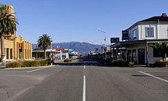
 Palmerston Street , the main shopping street in Westport |
||
Westport is a town in the Buller District of the West Coast regionon the South Island of New Zealand . The city is the seat of the Buller District Council .
geography
The city is located around 84 km north-northeast of Greymouth and around 60 km west of Murchison , right at the mouth of the Buller River in the Tasman Sea . The cliffs of the famous Cape Foulwind are around 11 km west of the city.
history
There is evidence that the area around the Buller River ( Kawatiri ) was inhabited by Māori . Legends place the first visit to the river in 950, when the Waka Tahiriangi landed on the coast of the estuary of the river under the leadership of Chief Ngahue . The Māori seem to have lived mostly on the coast, although they also dug in the mountains for pounamu , a type of jade that was traded with other tribes ( iwi ).
The first European settlers came to Westport as gold prospectors in 1861 . The first European ship to sail up the Buller River was the Three Brothers schooner with a seal hunter on board in 1884 . In the 1880s there were numerous exploratory trips by geologists and land surveyors who searched the land for valuable raw materials and measured it. Among them were Charles Heaphy , William Fox and Thomas Brunner . Initially it was gold finds that drew interest in this area and gold prospectors initially sifted large areas in the coastal area, which consisted of sediment deposits of the river, for gold. But coal was soon found in the hinterland, which has been mined to this day.
The first railroad was built as early as 1874 from Westport 18 km up to the coal mines, most of which are in the north of the city. The first section of the railway from Westport to Fairdown via Sergeants Hill was opened on December 31, 1875. This line finally reached Seddonville in 1895 and was then named Seddonville Branch . From these beginnings a network of branch lines, isolated from the railway network of the South Island, developed. A connection to the network of the South Island was only created in 1942 with the completion of the Stillwater – Westport Line through the Buller Gorge .
population
In the 2013 census, the town had 4,035 inhabitants, 3.5% more than in the 2006 census.
economy
The city gained economic importance through coal mining, agriculture, forestry and dairy farming. The largest industrial operation, however, is the cement works of the Holcim company , which also operates the port of Westport and uses it to ship the cement, at Cape Foulwind . Stockton is home to the largest open-cast coal mine in the country, but the number of jobs is increasing due to lower demand of coal on the world market.
Infrastructure
Road traffic
Traffic is connected Technically Westport by the New Zealand State Highway 6 , which from the northeast of Nelson through the gorge Buller Gorge progressing, south of the city on the coast to Greymouth leads.
Rail transport
In Westport the ends Stillwater-Westport Line , a railway between Westport and Stillwater near Greymouth , which Reefton leads and for transporting coal from the mines near Reefton is used.
Air traffic
There is also a small airport with daily Air New Zealand flights and Eagle Air flights to Wellington Monday through Friday .
media
The city's only daily newspaper is Westport News .
Attractions
Sights in the vicinity of the city are the Oparara Basin Arches and Cape Foulwind with a large colony of fur seals. The NBS Theater with a total of 474 seats is used for cinema, theater and other events. The theater opened on March 6, 2010.
tourism
Rafting and jet boating in Buller Gorge are popular pastimes. Westport is the starting point for visiting Karamea via an extension of New Zealand State Highway 67 . The Coaltown Museum in Westport represents the history of the Buller District .
See also
literature
- Helga Neubauer: Westport . In: The New Zealand Book . 1st edition. NZ Visitor Publications , Nelson 2003, ISBN 1-877339-00-8 , pp. 992 f .
Web links
- About Buller - Westport . Buller District Council,accessed September 21, 2014.
Individual evidence
- ↑ a b 2013 Census QuickStats about a place: Westport urban . Statistics New Zealand , accessed July 16, 2016 .
- ↑ a b Topo250 maps . Land Information New Zealand , accessed October 27, 2017 .
- ↑ a b History . Buller District Council , accessed September 21, 2014 .
- ^ Westport . Westport Visitors Center , archived from the original on August 19, 2007 ; accessed on September 21, 2014 (English, original website no longer available).
- ^ Westport Harbor . (PDF; 2.1 MB) In: Transactions and Proceedings 1868–1961 . Royal Society of New Zealand , accessed October 25, 2017 .
- ↑ a b Westport . In: The New Zealand Book . 2003, p. 992 .
- ↑ Stockton Mine . Stockton Mine , archived from the original on March 26, 2017 ; accessed on May 23, 2019 (English, original website no longer available).
- ↑ Airport . Buller District Council , accessed September 21, 2014 .
- ↑ Theaters . Buller District Council , archived from the original on August 20, 2010 ; accessed on January 11, 2016 (English, original website no longer available).
- ^ West Coast History . New Zealand Tourism Guide , accessed October 27, 2017 .


