Cape Foulwind
| Cape Foulwind | ||
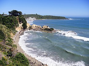
 Cape Foulwind with Gibson's Beach , view from the settlement Cape Foulwind in west-northwest direction |
||
| Geographical location | ||
|
|
||
| Coordinates | 41 ° 45 ′ S , 171 ° 28 ′ E | |
| location | Buller District , Region 1 = West Coast , South Island | |
| Waters | Tasman Sea | |
| length | 0.22 m | |
| width | 0.34 m | |
| height | 64 m | |
| lighthouse | Cape Foulwind Lighthouse | |
 Cape Foulwind Lighthouse with transmitter mast on the left |
||
Cape Foulwind is a cape in the Buller District of the West Coast regionon the South Island of New Zealand .
Origin of name
Abel Tasman , who discovered New Zealand in 1642, originally named the cape Clyppygen Hoeck (Rocky Corner). The name of the cape, which is still used today, came from the British navigator and explorer Captain James Cook , who saw the cape in terrible weather in 1770 and therefore gave it the name " Foulwind " , which translates as "hideous wind" .
geography
The cape is located approximately 11 km west of Westport and is on the New Zealand State Highway 67A and the Lighthouse Road from Westport to reach out. However, a view of the cape is only possible from the small settlement Cape Foulwind , east of the cape on Gibson's Beach .
Cape Foulwind Lighthouse
The Cape Foulwind Lighthouse is located 500 m southwest of the coast of the Cape and can be reached from the car park via a short hiking trail. The predecessor of today's lighthouse was put into operation in 1876 and consisted of a wooden structure. A new concrete tower was built behind this in the mid-1920s and put into operation in 1926. Visiting the tower is not possible.
Seal colony
From the parking lot near the lighthouse, the Cape Foulwind Walkway leads southwest of the cape at a high level along the coast to Tauranga Bay . The entire length of the hiking trail gives good views of the picturesque coastal landscape on this section. At the height of the offshore island of Wall Island is the seal colony, which attracts numerous tourists from Westport to the Cape.
The 2.9 km long path and the lookout point with a view of Wall Island are managed by the Department of Conservation , which clearly explains the flora and fauna of the coastal section with numerous information boards at the lookout point and along the way.
Web links
- Homepage . Westport Tourism New Zealand,accessed June 27, 2018.
Individual evidence
- ↑ Information board on the way to the lighthouse, photographed on February 27, 2017
- ↑ Topo maps . Land Information New Zealand , accessed June 27, 2018 .
- ↑ Cape Foulwind . Maritime New Zealand , accessed June 27, 2018 .
- ↑ Cape Foulwind Walkway . Department of Conservation , accessed June 27, 2018 .

