
Reefton (New Zealand)
| Reefton | ||
| Geographical location | ||
|
||
| Coordinates | 42 ° 7 ′ S , 171 ° 52 ′ E | |
| Region ISO | NZ-WTC | |
| Country |
|
|
| region | West coast | |
| District | Buller District | |
| Ward | Inangahua Ward | |
| Residents | 1 026 (2013) | |
| height | 162 m | |
| Post Code | 7830 | |
| Telephone code | +64 (0) 3 | |
| Photography of the place | ||
 Main thoroughfare of the place |
||

.jpg)
Reefton is a town in the Buller District of the West Coast regionon the South Island of New Zealand .
geography
The place is located around 45 km southeast of Westport and around 65 km northeast of Greymouth in the valley of the Inangahua River . Reefton is surrounded by mountains up to 1000 m high , except for its north side . A small plain opens to the north, which extends to the Waitahu River .
history
Reefton was the first place in the southern hemisphere to receive electricity in 1888. Soon after, the streets were lit up with electricity produced commercially by a water turbine. Gold was first discovered in the Reefton area in 1866, but the main veins were not found until 1870. Shortly thereafter, the place briefly had several thousand inhabitants. The rich gold veins found in a quartz reef near the site led to its current name, as well as the earlier name Quartzopolis .
economy
The place is still characterized by gold and coal mining today. Coal mining, forestry and tourism are the most important industries of the place today.
Infrastructure
Road traffic
The New Zealand State Highway 7 runs through Reefton and connects the town with Greymouth in the southwest and across the New Zealand Alps with parts of the Canterbury region. In the place branches off from State Highway 7 of New Zealand State Highway 69 to the north and connects Reefton via Inangahua Junction with New Zealand State Highway 6 and further west with Westport .
Rail transport
Reefton is on the Stillwater-Westport Line , which branches off the Midland Line in Stillwater . The route was opened on February 29, 1892, but ended at that time on the southern bank of the Inangahua River across from Reefton . At the beginning of the 20th century a bridge was built over the river and what is now the train station in Reefton . The route was extended to Cronadun in 1908 . It was only on December 5, 1943, that the line was officially declared a through route to Westport , although the line had been served by trains since July 1942. On August 3, 1936, passenger traffic was started between Hokitika and Reefton . Small NZR-RM diesel multiple units from Leyland were used . Due to insufficient customer numbers, traffic to Reefton was suspended in August 1938.
In the early 1940s, Vulcan multiple units were introduced in New Zealand and served two routes to Reefton , a local connection from Greymouth that ended in Reefton and a connection between Westport and Stillwater . The latter connected the place with the West Coast Express . In 1967 the passenger traffic was stopped. Today, the route is mainly used by several coal trains every day.
Education
The first public school was established in the region in 1878. There were once 24 schools in the area.
With the Reefton Area School, the location has a composite school with grades 1 to 13. In 2015, 192 students attended the school. The Sacred Heart School is a primary school with grades 1 to 8. In 2015, 25 students attended the school.
Photo gallery
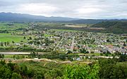
Aerial view of the place
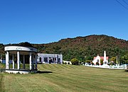
King George Park

Lantern Court Motel
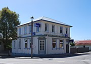
Reefton BNZ Bank


See also
Web links
Individual evidence
- ↑ 2013 Census QuickStats about a place: Reefton . Statistics New Zealand , accessed July 16, 2016 .
- ↑ a b Topo250 maps . Land Information New Zealand , accessed October 7, 2017 .
- ↑ Malcolm McKinnon (Ed.): New Zealand Historical Atlas . David Bateman , Auckland 1997, ISBN 978-1-86953-335-9 (English).
- ^ District School Reunion . (PDF (141 kB)) Hometown Reefton , archived from the original on May 26, 2010 ; accessed on September 8, 2014 (English, original website no longer available).
- ^ Reefton Area School . Education Review Office , accessed October 7, 2017 .
- ^ Sacred Heart School . Education Review Office , accessed October 7, 2017 .