
Narni
| Narni | ||
|---|---|---|

|
|
|
| Country | Italy | |
| region | Umbria | |
| province | Terni (TR) | |
| Coordinates | 42 ° 31 ′ N , 12 ° 31 ′ E | |
| height | 240 m slm | |
| surface | 198 km² | |
| Residents | 18,887 (Dec. 31, 2019) | |
| Population density | 95 inhabitants / km² | |
| Post Code | 05035 - 05036 Scalo | |
| prefix | 0744 | |
| ISTAT number | 055022 | |
| Popular name | Narnesi | |
| Patron saint | San Giovenale di Narni (May 3rd) | |
| Website | Narni | |
 Panorama of Narni |
||

Narni ( Latin: Narnia ) is an Italian municipality in Umbria with 18,887 inhabitants (as of December 31, 2019).
geography
.svg)
The place is located 240 m slm above the valley of the river Nera in the province of Terni. The community extends over around 198 km². It is located about 67 km south of Perugia and about 10 km southwest of Terni in the climatic classification of Italian communities in zone D, 1802 GG.
The districts include Borgaria, Capitone, Cigliano, Guadamello, Gualdo, Itieli, Montoro, Nera Montoro, Narni Scalo, Ponte San Lorenzo, San Faustino, San Liberato, Santa Lucia, Sant'Urbano, San Vito, Schifanoia, Stifone, Taizzano, Testaccio and Vigne.
The neighboring municipalities are Amelia , Calvi dell'Umbria , Montecastrilli , Orte ( VT ), Otricoli , San Gemini , Stroncone and Terni.
history

Originally there was a settlement called Nequinum at this point of the Osco-Umbrian tribes, which dates back to 600 BC. Is mentioned. In the course of the Samnite Wars , Nequinum came under Roman rule, with the Romans renaming the city to Narnia ( Greek Ναρνία ) after the river Nar (today: Nera ) ; the old name was too negative for the Romans echoes because nequeo in Latin I can not and nequitia worthlessness means. In the context of the Roman expansion into northern central Italy, Narnia was of particular strategic importance. BC completed. Via Flaminia the River Nar and also another highway to Spoletium (Spoleto) and Reate (Rieti) branched off. 299 BC BC Narnia became a Roman municipality . When Narnia refused to support Rome against Carthage during the Second Punic War , the city was destroyed, but later rebuilt.
During the Great Migration , Narni was devastated again. The Lombards installed a local governor ( gastald ) here . In the 10th century the city was part of Emperor Otto I and finally came into the possession of the Margravine Mathilde . In 1112 Narni was in opposition to Pope Paschal II and in 1167 to Emperor Friedrich Barbarossa , whereupon the emperor retaliated against the city. As a result, Narni supported the anti-imperial party of the Guelphs and allied himself in 1242 with Perugia and Rome .
In the 14th century, Cardinal Albornoz ensured that Narni was again subjected to the rule of the Papal States. Not only the Rocca dates from this period, but also the Loggia dei Priori and the colonnade leading to the Piazza dei Priori.
Later, Narni became a fiefdom of the Orsini , was briefly occupied by King Ladislaus of Naples in the 15th century , but then came back to the Papal States thanks to Braccio da Montone . On July 15, 1525, German mercenary troops of Emperor Charles V reached the city and laid it to rubble - a blow from which Narni never really recovered. From now on, Narni was always in the shadow of its local rival Terni, which is just under 10 km north . Since 1860 Narni belonged to the united Italian kingdom.
Attractions
- Narni Cathedral (known as the Concattedrale di San Giovenale or Duomo di Narni ), construction started in 1047 and completed by Pope Eugene III in 1145 . was consecrated . In the 15th century the simple facade was given a portico . The south portal, framed with tendrils, is flanked by lions. The polygonal apse was renewed in a Gothic style after a landslide in 1332 . The precious furnishings include the work of Sant'Antonio Abate by Vecchietta , a wooden statue from 1474.
- Chiesa di San Domenico , former church that was built in the 12th century. It was the first cathedral in town and was taken over by the Dominicans in 1304 .
- Chiesa di San Francesco , church from the 14th century
- Chiesa di Sant'Agostino , 14th century church, was renovated in 1728. Contains the fresco Madonna col Bambino sulle ginocchia tra Santa Lucia e Santa Apollonia from 1492 by Piermatteo d'Amelia .
- Chiesa di Santa Maria Impensole , built in 1175, “in pensole” (on the slope), three-aisled basilica . Inside, the front right capital shows the only figurative "Daniel in the lions' den".

- Porta Nuova , city gate from the 16th century
- Porta Ternana , city gate from the 15th century, was formerly called Porta dell'Arvolta
- Palazzo del Podestà , palace from the 13th century, today's town hall
- Ponte Calamone , Roman bridge on Via Flaminia
- Ponte Cardaro , Roman bridge on Via Flaminia
- Ponte d'Augusto (part of the Via Flaminia) over the river Nera , an arch bridge still stands today; the around 30 meters high building was one of the largest bridges built by the Romans.
- Rocca Albornoz , commissioned by Gil Álvarez Carillo de Albornoz , a 14th century castle built at the highest point of the city (332 meters above sea level ).
- Speco di San Francesco , a solitary convent about 13 km southeast of the town , founded by St. Francis in 1213 and renewed by St. Bernardine in the first half of the 15th century .

San Giovenale Cathedral

Interior of the cathedral

Side portal of the cathedral

San Francesco Church

Santa Maria Impensole

Medieval fountain
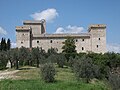
Albornoz Castle

Convento Lo Speco

San Cassiano Abbey


Center of Italy

Near Narni is the geographic center of Italy at the coordinates 42 ° 30'26.58 "north and 12 ° 32'16.86" east. This location marks a part of the old aqueduct that the Romans built. The Piazza San Rufo in Rieti, which is about 35 kilometers away, is often incorrectly referred to as the center of Italy. In Rieti there is a marble disc on the Piazza San Rufo, which marks this point. The calculations from 1994 resulted in Ponte Cardona at the coordinates mentioned as “L'ombelicolo d'Italia”.
traffic
- The place is with the stops Narni and Narni Montoro on the railway line Roma - Ancona in the section Orte - Falconara Marittima .
- Narni is connected to the road network by the SS675 state road (Strada Statale) .
sons and daughters of the town
- Nerva (30–98), Roman emperor
- Erasmus of Narni (1370–1443), Condottiere
- Berardo Eroli (1409–1479), cardinal vicar
- Galeotto Marzio (around 1427–1497), humanist, historian, doctor and astronomer in the Renaissance
- Lucia Broccadelli von Narni (1476–1544), beatified Catholic mystic of the Dominican order in 1710
- Felice Anerio (1560–1614), composer
- Augustyn Locci (1601–1660), engineer, builder and interior designer
- Giuseppe Sacripante (1642-1727), cardinal
- Laura Agea (* 1978), politician
reception
The author CS Lewis named the eponymous country of his novel series The Chronicles of Narnia after the Latin name of Narni, Narnia .
literature
- Touring Club Italiano : Umbria , Milan 1999, ISBN 88-365-2542-3 , p. 549 ff.
- Klaus Zimmermanns: Umbria . DuMont Buchverlag , Cologne 1987, pp. 326–332, ISBN 3-7701-1815-4 .
Web links
- Official site (Italian)
Individual evidence
- ↑ Statistiche demografiche ISTAT. Monthly population statistics of the Istituto Nazionale di Statistica , as of December 31 of 2019.
- ↑ Website of the Agenzia nazionale per le nuove tecnologie, l'energia e lo sviluppo economico sostenibile (ENEA) (PDF; 330 kB), accessed on November 20, 2012 (Italian)
- ↑ Official website of the ISTAT (Istituto Nazionale di Statistica) on 2001 population figures in the province of Terni, accessed on November 18, 2012 (Italian)
- ↑ Reference to the centro geografico
- ↑ Real-Life 'Narnia' inspired author. In: italy magazine. May 25, 2009, accessed November 13, 2015 .
Acquasparta | Allerona | Alviano | Amelia | Arrone | Attigliano | Avigliano Umbro | Baschi | Calvi dell'Umbria | Castel Giorgio | Castel Viscardo | Fabro | Ferentillo | Ficulle | Giove | Guardea | Lugnano in Teverina | Montecastrilli | Montecchio | Montefranco | Montegabbione | Monteleone d'Orvieto | Narni | Orvieto | Otricoli | Parrano | Penna in Teverina | Polino | Porano | San Gemini | San Venanzo | Stroncone | Terni