
Arrone
| Arrone | ||
|---|---|---|

|
|
|
| Country | Italy | |
| region | Umbria | |
| province | Terni (TR) | |
| Coordinates | 42 ° 34 ' N , 12 ° 46' E | |
| height | 239 m slm | |
| surface | 40 km² | |
| Residents | 2,703 (Dec. 31, 2019) | |
| Population density | 68 inhabitants / km² | |
| Post Code | 05031 | |
| prefix | 0744 | |
| ISTAT number | 055005 | |
| Popular name | Arronesi | |
| Patron saint | San Giovanni Battista (June 24th) | |
| Website | Arrone | |
 Panorama of Arrone |
||

Arrone is an Italian commune with 2703 inhabitants (as of December 31, 2019) in the province of Terni in the Umbria region and is a member of the association I borghi più belli d'Italia (The Most Beautiful Places in Italy).
geography
.svg)
Arrone is located in the southeast of Umbria on the border with the province of Rieti ( Lazio ) in the valley of the river Nera , about 15 km east of the provincial capital Terni and 66 km south-east of the regional capital Perugia in the climatic classification of Italian municipalities in zone D, 1,800 GG. The municipality belongs to the Parco Fluviale del Nera Natural Park . The place is part of the administrative community Comunità montana Valle del Nera e Monte San Pancrazio .
The municipality consists of the main town Arrone, which is located on a hill on the left side of the Nera, and the districts Buonacquisto, Casteldilago, Castiglioni, Colle Sant'Angelo, Palombare, Rosciano, Tripozzo, Vallecupa and Valleludra.
The neighboring municipalities are Ferentillo , Labro ( RI ), Montefranco , Morro Reatino (RI), Polino and Terni .
history
Arrone emerged as a settlement around a castle founded at the end of the 9th century by a Roman family of the same name. In the Middle Ages, the place was important because it was on the road that connected Abruzzo to the Duchy of Spoleto via Rieti . From 1229 to the 15th century the place belonged to the Duchy of Spoleto, then, until the Italian unification, to the Papal States . The municipal statute dates from 1542.
Attractions
The main town Arrone consists of two medieval settlements, the higher La Terra within the walls of the medieval castle, and Santa Maria at the foot of the hill. Another settlement with a medieval core is the district of Casteldilago .
- Chiesa di San Giovanni Battista - Church in La Terra (14th – 15th centuries). In the apse there are frescos from the Umbrian school from the 15th century.
- Chiesa di Santa Maria - three-aisled church with a portal from the 15th century. In the interior there are frescoes by Vincenzo Tamagni , Giovanni da Spoleto ( Storie della Vergine ) and Jacopo Siculo , as well as pictures by artists of the Umbrian school.
- Convento di San Francesco - former convent, now a congress center
- Chiesa di San Nicola - Church in Casteldilago, with frescoes by Lo Spagna (Giovanni di Pietro), 16th century
- Santuario della Madonna dello Scoglio - pilgrimage church in Casteldilago

Chiesa di San Giovanni Battista

Apse of the Church of San Giovanni

Chiesa di Santa Maria
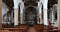
View to the altar of S. Maria
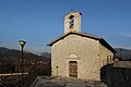
Chiesa di San Lorenzo in Casteldilago

Inside of the Church of San Lorenzo
.jpg)
.jpg)


Regular events
- Feast of the patron saint San Giovanni Battista (June 24th)
- Trofeo delle Acque - Canoeing competition on the Nera River (first Sunday in July)
economy
The municipality of Arrone lives from agriculture (olive cultivation, typical products such as truffles , trout), handicrafts and sporty tourism (canoeing, rafting , trekking , climbing).
Personalities
- Guido Balzarini (1874–1935), fencer
literature
- Touring Club Italiano : Umbria. Touring Editore, Milan 1999, ISBN 8836513379 .
Web links
- Official website of the municipality of Arrone (Italian)
- umbriatourism.it: Arrone , pictures and interesting facts (German)
Individual evidence
- ↑ Statistiche demografiche ISTAT. Monthly population statistics of the Istituto Nazionale di Statistica , as of December 31 of 2019.
- ^ I borghi più belli d'Italia. Borghipiubelliditalia.it, accessed August 13, 2017 (Italian).
- ↑ Website of the Agenzia nazionale per le nuove tecnologie, l'energia e lo sviluppo economico sostenibile (ENEA) (PDF file; 322 kB), accessed on December 2, 2012 (Italian)
- ↑ Official website of ISTAT (Istituto Nazionale di Statistica) on 2001 population figures in the province of Terni, accessed on December 2, 2012 (Italian)
Acquasparta | Allerona | Alviano | Amelia | Arrone | Attigliano | Avigliano Umbro | Baschi | Calvi dell'Umbria | Castel Giorgio | Castel Viscardo | Fabro | Ferentillo | Ficulle | Giove | Guardea | Lugnano in Teverina | Montecastrilli | Montecchio | Montefranco | Montegabbione | Monteleone d'Orvieto | Narni | Orvieto | Otricoli | Parrano | Penna in Teverina | Polino | Porano | San Gemini | San Venanzo | Stroncone | Terni