
Otricoli
| Otricoli | ||
|---|---|---|

|
|
|
| Country | Italy | |
| region | Umbria | |
| province | Terni (TR) | |
| Coordinates | 42 ° 25 ′ N , 12 ° 29 ′ E | |
| height | 209 m slm | |
| surface | 27.27 km² | |
| Residents | 1,807 (Dec. 31, 2019) | |
| Population density | 66 inhabitants / km² | |
| Post Code | 05030 | |
| prefix | 0744 | |
| ISTAT number | 055024 | |
| Popular name | Otricolani | |
| Patron saint | Victor and Corona (May 14th) | |
| Website | Otricoli | |
 Panorama of Otricoli |
||

Otricoli is an Italian commune with 1807 inhabitants (as of December 31, 2019) in the province of Terni in the Umbria region .
geography
.svg)
The community extends over around 28 km² . It is located about 90 km south of the regional capital Perugia and about 25 km southwest of the provincial capital Terni on a hill next to the Tiber and just southeast of its confluence with the Nera in the climatic classification of Italian communities in zone D, 1745 GR / G.
The place is on the SS 3 state road and is accessed from here through the Porta Maggiore. The second city gate is Porta San Severino, which is connected to the main gate by today's streets Via Vittorio Emanuele II and Via Cavour.
The only part of the municipality is Poggio, located approx. 9 km northeast.
The neighboring municipalities are Calvi dell'Umbria , Gallese ( VT ), Magliano Sabina ( RI ), Narni , Orte (VT) and Stroncone .
history
main place
The first settlements arose in what is now the local area in the 8th century BC. In the area of Sgorga on the banks of the Tiber. In 308 BC The place was still called Ocriculum and was allied with Rome to support its trade on the Tiber. This is where the Porto dell'Olio (oil port) originated , which was active until the end of the 18th century. The place was destroyed in the Roman alliance war. In the time of the Umbrian - Sabines , what is now the center of the village was moved to the hill and a city wall made of tuff stone without mortar connections was already built . The Via Flaminia (220 BC, today Via Roma), which runs alongside the city gate , strengthened the site as a Roman trading post. In the years between 569 and 605 the place suffered severely under the occupation of the Lombards , after which the settlement came under the influence of the Papal States , to which it submitted around 1000 after disputes with Narni . The place remained there until 1860, when Umbria became a region of Italy as part of the Risorgimento . The town council was elected for the first time in 1861, and Count Francesco Ruiz De Cardenas became mayor (Sindaco). In 1943 Otricoli was the location of a German military command. The subsequent bombing left damage to the town hall, Casa Birelli and the city gate Porta Maggiore . The peak of the population development was the 1950s, when more than 2,300 people lived in the village.
District of Poggio

Poggio, also called Poggio di Otricoli , is located on a western branch of Monte San Pancrazio (1028 m) at an altitude of 314 meters and has about 380 inhabitants. Poggio is mentioned for the first time in writing on April 14, 1237, when Tebalduccio Dorgani di Narni acquired part of the castle. In these documents the place is referred to as Castrum Podii Medii and Poggium Moggii . In 1276 the city of Narni gained control of the place. It was not until 1815, after the Napoleonic Wars, that Poggio freed himself from the rule of Narnis and became part of the municipality of Otricoli.
Attractions


- Collegiata di Santa Maria Assunta , main church in the center from the 7th century. The high altar dates from the 12th century, the marble ciborium from 1500. The right side of the church has the chapels of San Fulgenzio and San Domenico (with the fresco of San Fulgenzio vescovo che distribuisce il pane ai poveri di Otricoli ) and the baptistery with a baptismal font from the 16th century. On the left are the chapels of Sant'Antonio Abate and that of the Madonna Addolorata .
- Chiesa di San Salvatore , already mentioned in 1235 as Cappella S. Salvatoris in the town center. Contains the fresco Madonna del Latte .
- Chiesa di San Giuseppe da Leonessa (also called Oratorio di San Giuseppe da Leonessa ), church and oratory in the town center were built in 1761.
- City walls: The first city walls were built in the 4th century BC. Then the city walls were built in the 7th century AD. The parts of the city wall that are visible today date from the 12th century. The older and disappeared city gates were in the same place as today's city gates:
- Porta Maggiore , eastern city gate to the Borgo.
- Porta San Severino , western city gate, facing Via Flaminia and the Tiber.
- Ocriculum , historical site of the sixth district (Umbria, or Umbria complexa agrumque Gallicam citra Ariminium ) of the Roman Empire. The temple of Jupiter , which also produced Zeus of Otricoli , was located here. The thermal baths (built around the 2nd century BC) and the theater (around the 1st century) were discovered in the 18th century. Today the name of the titular bishopric Otriculum still reminds of the place.
- Castello delle Formiche , today's castle ruins on the river Aia shortly before the confluence with the Tiber, which was built in the 12th century and which is about 2 km southwest of Otricoli. The castle was a multiple trigger for conflicts between Otricoli and Amelia during disputes in the Middle Ages.
- Porto dell'Olio , former port (oil port) on the Tiber, which was used until the 18th century.
- Chiesa di San Vittore , in 1227. mentioned church near the Porto dell'Olio on the Tiber, as Benedictine - monastery arose. It was destroyed by a flood of the Tiber at the end of the 16th century and rebuilt in 1579. The part that is visible today was built in 1714 next to the ruins of the old monastery.
- Chiesa di San Fulgenzio , a church on the Antica Via Flaminia . It contained the remains of San Fulgenzio until 1316 when the relics were brought to the Collegiata. Contains the Museum Antiquarium Casale San Fulgenzio .

- Chiesa di San Nicola , the main church in the Poggio district, was built in the 15th century.
- Chiesa di San Vittore near the Poggio district, a church from the 14th century.
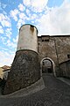
Main gate Porta Maggiore

City gate Porta San Severino
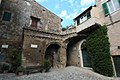
Piazza Garibaldi in the center of the village near the Collegiata


traffic
- The place is on Strada Statale 3 Via Flaminia . The next connection point to the long-distance traffic is Magliano Sabina , it is located on the Autostrada A1 ( Autostrada del Sole ) about 5 km south.
- The nearest railway stations on the railway line Florence-Rome are places Scalo and Gallese-Teverina (Scalo Teverina).
Community partnerships
- Mstòw , Powiat Częstochowski , Poland , since 2006.
literature
- Touring Club Italiano : Umbria. Milan 1999, ISBN 88-365-2542-3 , p. 565 ff.
- Touring Club Italiano: Piccole città, Borghi e Villaggi. Vol. II, Milan 2007, ISBN 978-88-365-4145-4 , pp. 254 ff.
Web links
- Official website of the Municipality of Otricoli (Italian)
- Website of the municipality for tourism (Italian)
- umbriatourism.it: Otricoli , pictures and interesting facts (English and Italian)
Individual evidence
- ↑ Statistiche demografiche ISTAT. Monthly population statistics of the Istituto Nazionale di Statistica , as of December 31 of 2019.
- ↑ Website of the Agenzia nazionale per le nuove tecnologie, l'energia e lo sviluppo economico sostenibile (ENEA) (PDF; 330 kB), accessed on November 18, 2012 (Italian)
- ↑ Official website of the municipality on the history of the main town, accessed on February 7, 2011 (Italian)
- ↑ Official website of ISTAT (Istituto Nazionale di Statistica) on 2001 population figures in the province of Terni, accessed on November 18, 2012 (Italian)
- ↑ Official website of the municipality on the history of the Poggio district, accessed on February 7, 2011 (Italian)
- ↑ a b c Website of the municipality (tourism) on the historic town center , accessed on October 5, 2015 (Italian)
- ↑ Official website of the municipality on the history of the main town, accessed on October 5, 2015 (Italian)
- ↑ Website Antica Via Flaminia to Porto dell'Olio , with illus., Accessed on October 5, 2015 (Italian)
- ↑ Website Antica Via Flaminia to Chiesa di San Vittore , with ill., Accessed on October 5, 2015 (Italian)
- ↑ Website Antica Via Flaminia to Chiesa di San Fulgenzio , with illus., Accessed on October 5, 2015 (Italian)
- ↑ Website Antica Via Flaminia to the Antiquarium Casale San Fulgenzio , with illus., Accessed on October 5, 2015 (Italian)
- ^ Official website of the parish on parish partnership , accessed on February 7, 2011 (Italian)
Acquasparta | Allerona | Alviano | Amelia | Arrone | Attigliano | Avigliano Umbro | Baschi | Calvi dell'Umbria | Castel Giorgio | Castel Viscardo | Fabro | Ferentillo | Ficulle | Giove | Guardea | Lugnano in Teverina | Montecastrilli | Montecchio | Montefranco | Montegabbione | Monteleone d'Orvieto | Narni | Orvieto | Otricoli | Parrano | Penna in Teverina | Polino | Porano | San Gemini | San Venanzo | Stroncone | Terni