
Avigliano Umbro
| Avigliano Umbro | ||
|---|---|---|

|
|
|
| Country | Italy | |
| region | Umbria | |
| province | Terni (TR) | |
| Coordinates | 42 ° 39 ' N , 12 ° 26' E | |
| height | 441 m slm | |
| surface | 51.32 km² | |
| Residents | 2,453 (Dec 31, 2019) | |
| Population density | 48 inhabitants / km² | |
| Post Code | 05020 | |
| prefix | 0744 | |
| ISTAT number | 055033 | |
| Popular name | Aviglianesi | |
| Patron saint |
Sant'Egidio (September 1st) |
|
| Website | Avigliano Umbro | |
 Panorama of Avigliano Umbro |
||

Avigliano Umbro is an Italian commune with 2,453 inhabitants (as of December 31, 2019) in the province of Terni in the Umbria region .
geography
.svg)
The community extends over around 51 km² . It is located about 60 km south of Perugia and about 20 km northwest of Terni in the climatic classification of Italian communities in zone E, 2 167 GG.
The districts include Dunarobba, Santa Restituta, Sismano and Toscolano.
The neighboring municipalities are Acquasparta , Amelia , Guardea , Montecastrilli , Montecchio and Todi ( PG ).
history
Districts like Santa Restituta were inhabited as early as the Neolithic . In the Middle Ages the place belonged to the Terre Arnolfe of the Signoria degli Arnolfi . In the 12th century the place fell under the rule of Todi . The community became independent in 1975 when the place was detached from Montecastrilli. The place is known for its chestnut production.
Attractions
- Castello di Santa Restituta , castle ruins from the 12th century on Monte Pianello in the district of Santa Restituta.
- Castello di Sismano , medieval castle of the Arnolfi.
- Castello di Toscolano , medieval castle from the 13th century, which was significantly expanded in 1442.
- Chiesa della SS. Annunziata , church with frescoes by Piermatteo d'Amelia (1448–1508) in the Toscolano district.
- Chiesa di Santa Maria Novella in the district of Santa Restituta, church containing relics of the Holy Restituta of Africa .
- Chiesa parrocchiale della SS. Trinità , built in 1617, contains frescoes by Bartolomeo Barbiani and the work Madonna del Rosario con Bambino, Santi e Misteri by Andrea Polinori.
- Forte Cesare , a medieval fortress originally built to protect against the passing Byzantines.
- Fortezza di Dunarobba , 11th century fortress.
- Grotta bella , stalactite cave discovered in 1902 at the foot of Monte Aiola in the district of Santa Restituta.
- Petrified Forest and Plant Paleontology Center in Dunarobba

Forte Cesare, view from the southwest

Inside view of the Grotta Bella

Interior of the church in Santa Restituta
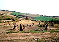
Petrified forest in Dunarobba
Centro di Paleontologia Vegetale


Community partnerships
- Benidoleig in the Valencia region , Spain
literature
- Touring Club Italiano : Umbria. Touring Editore, Milan 1999, ISBN 8836513379 , p. 515.
Web links
- Official website of the municipality of Avigliano Umbro (multilingual)
- Website of the Pro Loco of the municipality of Avigliano Umbro (Italian)
Remarks
- ↑ a b In 2012 an uninhabited ruin, the roof of which has already collapsed. (not shown in the photo)
- ↑ a b No longer publicly accessible in 2012 because the footbridges are dilapidated.
Individual evidence
- ↑ Statistiche demografiche ISTAT. Monthly population statistics of the Istituto Nazionale di Statistica , as of December 31 of 2019.
- ↑ Website of the Agenzia nazionale per le nuove tecnologie, l'energia e lo sviluppo economico sostenibile (ENEA) (PDF; 330 kB), accessed on December 2, 2012 (Italian)
- ↑ Official website of ISTAT (Istituto Nazionale di Statistica) on 2001 population figures in the province of Terni, accessed on December 2, 2012 (Italian)
- ↑ The land of water and cyclamen, folder: DITT, www.ditt.it
- ↑ umbriatourism.it: Centro di Paleontologia vegetale della foresta fossile di Dunarobba , accessed on October 31, 2018 (German)
Acquasparta | Allerona | Alviano | Amelia | Arrone | Attigliano | Avigliano Umbro | Baschi | Calvi dell'Umbria | Castel Giorgio | Castel Viscardo | Fabro | Ferentillo | Ficulle | Giove | Guardea | Lugnano in Teverina | Montecastrilli | Montecchio | Montefranco | Montegabbione | Monteleone d'Orvieto | Narni | Orvieto | Otricoli | Parrano | Penna in Teverina | Polino | Porano | San Gemini | San Venanzo | Stroncone | Terni