Treriksröset
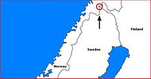
Treriksröset ( Swedish ), Treriksrøysa ( Norwegian ), Kolmen valtakunnan rajapyykki ( Finnish ) or Golmma riikka urna ( North Sami ) (literally translated: Three-Kingdoms-Grenzmal ) is the border triangle of Sweden , Norway and Finland .
The border monument was created in 1897 and was built by the governments of Norway and Russia at the time. The Swedish government initially did not want to recognize this border mark with Norway and only added its border mark in 1901. Treriksröset is located on the Swedish side in the municipality of Kiruna and is the northernmost point in Sweden and also the westernmost point on the Finnish mainland. The distance between Treriksröset and Smygehuk , Sweden's southernmost point, is 1572 kilometers.
Today's border monument at Treriksröset, built in 1926, is about ten meters in Lake Goldajärvi (also known as Koltajauri ) and is a round, slightly curved, yellow-painted concrete block.
Web links
Individual evidence
- ↑ Statistiska centralbyrån: Geografiska uppgifter, p. 12 (PDF; 77 kB)
Coordinates: 69 ° 3 ′ 35.9 ″ N , 20 ° 32 ′ 55.1 ″ E

