Rožaje
|
Rožaje Рожаје |
|||
|
|||
| Basic data | |||
|---|---|---|---|
| State : |
|
||
| Coordinates : | 42 ° 51 ' N , 20 ° 10' E | ||
| Height : | 1015 m. i. J. | ||
| Area : | 432 km² | ||
| Residents : | 9,121 (2003) | ||
| Population density : | 21 inhabitants per km² | ||
| Telephone code : | (+382) 051 | ||
| Postal code : | 84310 | ||
| License plate : | RO | ||
| Structure and administration | |||
| Community type : | Opština | ||
| Mayor : | Ejup Nurkovic (BS) | ||
| Postal address : | Ul. Maršala Tita 84310 Rožaje, Montenegro |
||
| Website : | |||
| Others | |||
| City Festival : | September 30th, Freedom Day | ||
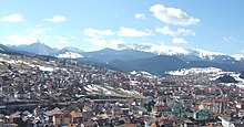
Rožaje ( Cyrillic Рожаје , Albanian Rozhaj / -a ) is a small town with 9,100 inhabitants in the easternmost area of Montenegro . It is located near the border between Montenegro, Serbia and Kosovo at an altitude of about 1015 m. The place is also the center of the Opština Rožaje with 22,700 inhabitants. The river Ibar , which rises here, and the 2403 m high Hajla are well-known natural beauties of the region.
location
The large municipality of Rožaje is isolated from the rest of Montenegro by a mountain range up to 1755 meters high. To the south, Rožaje is cut off from Kosovo by the Hajla and Mokra Gora mountains . The large municipality comprises the uppermost part of the Ibar valley, which is why Rožaje is only open in an easterly direction towards central Serbia . However, Rožaje is connected to the rest of Montenegro by a tunnel and mountain passes. The main M-2 road running through the tunnel leads to the town of Berane on the other side of the mountain range . In the opposite direction, this main road connects the city with Kosovska Mitrovica in Kosovo and with Novi Pazar via a junction . Another road leads over a 1795 meter high pass to Peć in Kosovo. During the Ottoman Empire, the city was part of the historical Sanjak region of Novi Pazar .
population
At the 2011 census, the municipality of Rožaje had 22,964 inhabitants, of whom 19,269 (83.91%) were Bosniaks , 1158 (5.04%) were Albanians , 1044 (4.55%) were ethnic Muslims , 822 (3.58 %) described them as Serbs and 401 (1.75%) as Montenegrins . The Albanians of Rožaje speak the Gegic dialect of Albanian .
economy
The community lives mainly from the timber industry and retail.
Attractions
The most important sight is the Ganića Kula (the tower of the Ganići), which was built at the beginning of the 19th century. Other landmarks are the Kurtagić Mosque (built on the orders of Sultan Murat II in 1697) and the Kučan Mosque (built in 1830).
sons and daughters of the town
- Zaim Azemović (* 1935), writer
- Ernes Erko Kalač (* 1964), karateka, integration ambassador for the German Olympic Sports Confederation
- Sejo Kalac (born 1964), singer
- Tarik Hadžić (* 1994), ski racer


