Spuž
|
Spuž Спуж |
||||
|
||||
| Basic data | ||||
|---|---|---|---|---|
| State : |
|
|||
| Municipality : | Danilovgrad | |||
| Coordinates : | 42 ° 30 ' N , 19 ° 12' E | |||
| Height : | 45 m. i. J. | |||
| Residents : | 1,529 (2003) | |||
| Postal code : | 81412 | |||
| License plate : | DG | |||
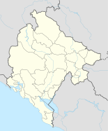
Spuž [ spuʒ ] ( Serbian - Cyrillic Спуж , Albanian Shpuzë / -a ) is a small Montenegrin town in the municipality ( opština ) Danilovgrad . It is located halfway between Podgorica and Danilovgrad in the Bjelopavlići valley on both sides of the Zeta . According to the 2003 census, the settlement had 1,529 inhabitants. Of these, 56.6% described themselves as Montenegrins and 33.2% as Serbs.
End of the 14th century, the place is a fortress of the Bosnian king Tvrtko I mentioned. From 1474 to 1878 İşpozi - the official place name in Turkish at the time - was part of the Ottoman Empire before it became part of the Kingdom of Montenegro . In the course of the Russo-Austrian Turkish War , on July 17, 1788, there was a skirmish between Imperial and Royal troops and Albanians allied with the Turks.
The place is known as the location of the probably largest Montenegrin prison ZIKS ( Zavod za izdržavanje kaznenih sankcija ). There is also a stopping point on the Nikšić – Podgorica railway line in Spuž .

