Tivat
|
Tivat Тиват |
||||
|
||||
| Basic data | ||||
|---|---|---|---|---|
| State : |
|
|||
| Coordinates : | 42 ° 26 ' N , 18 ° 42' E | |||
| Height : | 5 m. i. J. | |||
| Residents : | 9,367 (2011) | |||
| Telephone code : | (+382) 032 | |||
| Postal code : | 85320 | |||
| License plate : | TV | |||
| Structure and administration | ||||
| Mayor : | Sinisa Kusovac ( DPS ) | |||
| Website : | ||||
Tivat ( Cyrillic Тиват ; pronunciation: [ tîv̞at ]) is a city in Montenegro . It is located on the Bay of Kotor and has almost 9400 inhabitants. The municipality of the same name has over 14,000 inhabitants.
history
Data from an archive in Kotor show that today's place was mentioned in the 14th century as Teude , Theode and Theudo . This name is believed to be associated with the Illyrian queen Teuta . In Italian the city is still called Teodo today .
Between 1420 and 1797 Tivat belonged to the Republic of Venice , from 1815 to 1918 to the Austro-Hungarian monarchy . In 1919 the area of the Bay of Kotor and with it Tivat fell to the newly formed Yugoslavia .
Because of its strategically important location at the entrance to the Bay of Kotor, Tivat was heavily occupied by Austro-Hungarian troops until 1918 , who also had to occupy the surrounding fortifications that still exist today . In garrison were here the III. Battalion of the Infantry Rgmt. No. 72 , the 1st Battalion of the Infantry Rgmt. No. 91 as well as the staff and the 1st battalion of the fortress artillery regiment No. 5.
geography
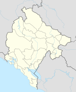
Tivat is about 19 kilometers away from Herceg Novi , 10 kilometers away from Kotor and 23 kilometers away from Budva . The Croatian Dubrovnik is 80 kilometers away and the Montenegrin capital Podgorica 90 kilometers.
The municipality of Tivat lies in three different geomorphological zones. Diene consists of the hills and mountains of the Vrmac peninsula . The second zone is the Tivat Plain, which has been flattened by the water. The third zone is Kroli with the islands: Flower Island. St. Marko.
population
At the 2011 census, the city of Tivat had 9,367 inhabitants, of whom 3,222 (34.40%) identified themselves as Montenegrins , 2928 (31.26%) as Serbs and 1622 (17.32%) as Croatians . In addition, many members of other ethnic groups or identities live in the city, and 768 people (8.20%) gave no information on their ethnic affiliation.
The entire Tivat municipality had 14,031 inhabitants, including 4666 (33.25%) Montenegrins, 4435 (31.61%) Serbs and 2304 (16.42%) Croats . In addition to members of many other population groups, there were 1275 people (9.09%) who did not want to indicate their ethnicity.
Infrastructure
The city has an airport about three kilometers away. The city also has a new yacht port called Porto Montenegro , which was previously an old shipyard.
Culture and sights
- Buća Luković residence
Of the numerous summer residences that noble families from Kotor had built in Tivat, only the tower of the Buća Luković residence is preserved today. This was built in 1548 by a certain Vićencije from Lastva . Initially, the Renaissance villa was owned by the Buća family and later it was owned by the Luković family. The tower, which still exists today, is an art and culture center and meeting point for cultural workers. The city museum is also housed in the tower.
- Outdoor stage
The open-air theater is in the immediate vicinity of the Buća Luković residence. Concerts as well as film and theater screenings take place here during the summer season.
- City Park ("Gradski Park")
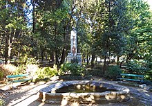
Over a hundred different tropical and subtropical plant species have been planted in the park, brought back by seafarers from all over the world. The park is the location of the monument to the two naval officers Milan Spasić and Sergej Mašeri . The two blew up the warship “Zagreb”, which was anchored in front of the city, thus preventing it from falling into the hands of the Italian crew. Both officers lost their lives in the maneuver.
- Church of St. Sava
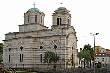
Between 1940 and 1966 the Serbian Orthodox Church was built in the center of Tivat and consecrated to Saint Sava .
- Solila
To the south of Tivat there are saline fields ("Solila") in the Solisko polje plain . Sea salt was extracted on site by local monks as early as the Middle Ages. At the beginning of the 20th century the salt pans lay fallow. It was not until the Second World War that sea salt production was resumed for a few years. The saline fields are now a nature reserve. The swampy ground forms the habitat for numerous protected plant species and is home to birds such as cormorants and flamingos.
Web links
Individual evidence
- ^ Tivat. In: mirjanadetelic.com. Retrieved May 3, 2017 (Serbian).
- ^ A b Ethnic composition of Montenegro 2011. In: pop-stat.mashke.org. Retrieved July 26, 2018 .
- ↑ a b c d Marko Plešnik: Montenegro. Between Adria and Black Mountains , Trescher Verlag , Berlin 2016, 5th edition, pp. 125/126


