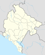
Šavnik
|
Šavnik Shavnik |
||||
|
||||
| Basic data | ||||
|---|---|---|---|---|
| State : |
|
|||
| Coordinates : | 42 ° 57 ' N , 19 ° 6' E | |||
| Height : | 825 m. i. J. | |||
| Area : | 553 km² | |||
| Residents : | 570 (2003) | |||
| Population density : | 1 inhabitant per km² | |||
| Telephone code : | (+382) 083 | |||
| License plate : | ŠN | |||
| Structure and administration | ||||
| Mayor : | Velimir Perišić | |||
| Website : | ||||
Šavnik ( Cyrillic Шавник ) is a place and the municipality of the same name ( Opština ) in northern Montenegro . The municipality covers 553 km² and has 2972 inhabitants (2003), making it the Montenegrin municipality with the smallest number of inhabitants. The place itself has only about 600 inhabitants. The municipality includes 27 settlements, of which Šavnik is the largest.
geography
Šavnik is located at the confluence of the mountain streams Bukovica , Šavnika and Bijela in a valley basin. a source river of the Piva . The surroundings of the place are impassable and mostly forested mountainous areas that are only sparsely populated. To the north of Šavnik lies the Treskavac Mountains, which adjoin the Durmitor massif and partly belong to the national park of the same name.
history
Šavnik has been part of Montenegro since 1878. In the parliamentary elections in September 2006, the municipality had the highest voter turnout in the country with 80%.
population
At the 2011 census, the municipality of Šavnik had 2070 inhabitants, of which 1114 (53.82%) described themselves as Montenegrins and 878 (42.42%) as Serbs .
economy
The place is the center of the regional timber industry. Some of the community's better-known agricultural products include fruit and honey, which is known across the country.
tourism
Šavnik is only a transit point on the route to the Durmitor National Park, the place itself has only one hotel. However, the small town of Boan in the upper Bukovica valley is to be expanded into a small ecotourism center in the next few years.
traffic
Šavnik is located halfway on the regional road from Nikšić to Žabljak . This was built in 1960 and at the same time represents the only developed connection to the rest of the country. The roads to Kolašin and the pass road to Nikšić are difficult or impossible to pass depending on the weather and the season. The nearby Ivica tunnel was opened in 2010.
Attractions
In the village there is a small Roman bridge over the Bukovica. Near Šavnik are the monasteries Bijela and Podmalinsko , north of the place is the Komarnica Canyon .
Personalities
- Radovan Karadžić (* 1945), former President of the Republika Srpska and convicted war criminal, was born in the municipality of Petnjica .
- Andrija Mandić (* 1965), politician
- Vlado Jeknić (* 1983), football player, was born in the village

