
Pljevlja
|
Pljevlja Пљевља |
|||
|
|||
| Basic data | |||
|---|---|---|---|
| State : |
|
||
| Coordinates : | 43 ° 21 ' N , 19 ° 21' E | ||
| Height : | 770 m. i. J. | ||
| Area : | 1,346 km² | ||
| Residents : | 21,337 (2003) | ||
| Population density : | 16 inhabitants per km² | ||
| Telephone code : | (+382) 052 | ||
| License plate : | PV | ||
| Structure and administration | |||
| Website : | |||

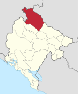

Pljevlja ( Cyrillic Пљевља ) is a city that is the administrative seat of the municipality of the same name ( Opština ) in northern Montenegro . With an area of 1346 square kilometers, it is the third largest municipality in Montenegro in terms of area and thus covers around ten percent of the country's territory.
Pljevlja is one of the most important industrial centers in the country due to the region's wealth of natural resources. There are also important tourist destinations such as the Tara Gorge. The Serbian border runs five kilometers northeast of the city.
geography

Pljevlja is located in the far north of Montenegro. The municipality borders Serbia in the north and Bosnia and Herzegovina in the west .
The municipality is located in the southern part of the Dinarides , which are formed here by the Kovač , Lisac and Ljubišnja mountain ranges . Here is also the highest point in the municipality with a height of 2238 meters above sea level. The mountains are partly forested, but partly they also have clear karst features .
The Ćeotina river (also spelled Ćehotina ), a tributary of the Drina , flows through the municipality and the town of Pljevlja, which lies in a cauldron-like valley at an altitude of about 770 meters . The Tara , another tributary of the Drina, forms the southwest border of the municipality with a gorge up to 1,300 meters deep. The place where Tara meets the Bosnian border also marks the lowest point in the municipality with a height of 520 meters.
The Breznica river flows right through the city center .
population


The municipality has 30,786 inhabitants (as of the 2011 census), the city of Pljevlja itself has 21,337 inhabitants and is the third largest city in the country. The municipality has 159 settlements, of which, apart from the town of Pljevlja, no more than 1000 inhabitants.
According to the 1991 census, the population of Pljevlja was:
- 55.35% Serbs
- 24.23% Montenegrins
- 17.59% Muslim in terms of nationality.
The 2011 census found:
history
The first settlements in the municipality already existed at the end of the last ice age about 10,000 years ago. The finds in the Mališina cave near the town of Pljevlja testify to this. There are other finds from early colonization from the Stone Age in Medena Stijena. Illyrian tribes lived here in the last millennium BC before the area was conquered by the Romans during the time of Emperor Augustus . They built a settlement of unknown name on the ruins of an Illyrian settlement in what is now the suburb of Pljevlja Komini. It was called Municipium S by the archaeologists because only the first letter of the place name was legible on a fragment of the inscription. This city was after Doclea (today's Bar ) the second largest in the area of today's Montenegro with a highly developed culture. In the ruins of the settlement, jewelry, terracotta objects and glass vases were found, among them the Diatreta glass vase, which is considered particularly valuable .
In the 6th century the area was settled by Slavs who established a place called Breznik (or Breznica ), which was first mentioned in 822. Due to its location on the trade routes from Dubrovnik , Trieste and Kotor to Constantinople , Belgrade and Sarajevo, the place flourished quickly and became an important trading center in the early Serbian principality of Raška . In the 14th century, the name Pljevlja appears for the first time next to Breznik for the place. The place was ruled by various Serbian, Bosnian and Herzegovinian kings and princes before it came to the Ottoman Empire in 1462 . The Ottomans renamed the place Taslidža and expanded it into a so-called Kasaba , a city without a fortress. Construction of the Holy Trinity Monastery in the north began in 1465, and that of the Hussein Pasha Mosque in the city center in 1569 . 1572 the seat of Herzegovinian was Sanjak to Taslidža laid. It was also at this time that the city received its first sewer system. The number of houses rose from 72 in 1468 to around 300 in 1570. The first Islamic school, Medresa, was built in the 17th century. At the beginning of the 19th century, Taslidža was the second largest city in the Herzegovinian sanjak after Mostar with 800 houses and around 7000 inhabitants . However, two big fires during this time caused great destruction, so that in 1833 the seat of the sanjak was moved to Mostar. This led to stagnation in the city's economic and cultural development.

In 1878 Pljevlja came under Austrian administration with the Sanjak of Novipazar , while the area was still formally part of the Ottoman Empire. In 1880 Pljevlja became the seat of a newly formed sanjak of the same name ( Sanjak Pljevlja , 1880-1913). As a border town, Pljevlja became a garrison with over 5000 soldiers and their families. This led to a transformation from an oriental to a western city. In 1880 the city received its first hospital and in 1889 the first brewery. In 1908 the Austrians withdrew again.
During the First Balkan War , Serbian and Montenegrin troops entered the city on the same day in 1912, thus finally ending Ottoman rule. The city became part of the Kingdom of Montenegro , which became part of the Kingdom of Serbs, Croats and Slovenes after the First World War . Here it became part of the newly formed Zeta Banschaft . After the end of the Second World War , the city became part of the Republic of Montenegro, within socialist Yugoslavia. Particularly in the 1960s and 1970s, due to the lignite finds in the area, it quickly developed into a modern industrial city.
economy

Pljevlja is one of the few industrial centers in Montenegro. About five kilometers southwest of the city is the only thermal power plant ("Termoelektrana Pljevlja") in the country, which is supplied with lignite from a nearby open pit mine . With an output of 210 megawatts , it supplies around 45% of the electrical energy required in the country. In addition, there is the mining Šuplja stijena in which zinc and lead can be promoted. There is also a diverse wood processing industry due to the abundance of forests in the municipality.
traffic
The streets of Mojkovac , Prijepolje (Serbia) and Goražde and Višegrad (both in Bosnia and Herzegovina ) cross in Pljevlja . The nearest train station is in Prijepolje, about 40 kilometers away, on the Belgrade – Bar railway line .
Personalities
- Varnava Rosić (1880–1937), Patriarch of the Serbian Orthodox Church
- Bogdan Tanjević (* 1947), Montenegrin basketball coach
- Darko Šarić (* 1969), alleged drug dealer
- Nenad Peruničić (* 1971), Montenegrin-German handball player
Web links
- Website of the municipality of Pljevlja (Serbian, Montenegrin, Albanian, English)
- Pljevlja page on visit-montenegro.com (English)
Individual evidence
- ↑ Data on Pljevlja ( Memento of the original from October 7, 2007 in the Internet Archive ) Info: The archive link was inserted automatically and has not yet been checked. Please check the original and archive link according to the instructions and then remove this notice. on the homepage of the Statistical Office of Montenegro
Andrijevica | Bar | Bečići | Berane | Bijela | Bijelo Polje | Budva | Cetinje | Danilovgrad | Dobrota | Donja Lastva | Gradac | Gusinje | Herceg Novi | Igalo | Kolašin | Kotor | Mojkovac | Nikšić | Perast | Petrovac na moru | Plav | Pljevlja | Plužine | Podgorica | Prčanj | Rijeka Crnojevića | Risan | Rožaje | Šavnik | Spuž | Stari Bar | Sutomore | Sveti Stefan | Tivat | Tuzi | Ulcinj | Virpazar | Žabljak | Zelenika