Andrijevica
|
Andrijevica Андријевица |
||||
|
||||
| Basic data | ||||
|---|---|---|---|---|
| State : |
|
|||
| Municipality : | Andrijevica | |||
| Coordinates : | 42 ° 44 ' N , 19 ° 47' E | |||
| Height : | 740 m. i. J. | |||
| Residents : | 1,048 (2011) | |||
| Telephone code : | (+382) 087 | |||
| License plate : | ON | |||
Andrijevica ( Cyrillic Андријевица ) is a small town in eastern Montenegro with a little over 1000 inhabitants. Andrijevica is the capital of the municipality named after her with over 5000 inhabitants and an area of 283 km².
geography
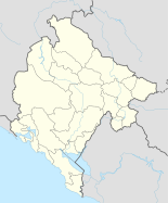
The place is located at the mouth of the Zlorečica in the upper reaches of the Lim , about 55 km northeast of Podgorica . It is connected to the capital by a mountain road that runs 81 km through the upper valley of the Tara .
Andrijevica is about 9 km from the border with Albania and 21 km from Serbia and Kosovo . Peja can be reached via a local road over the Čakorpass .
history
The place Andrijevica is relatively young and was founded in the middle of the 19th century, when a settlement expanded around the church of Andrija from 1853 . At that time the area belonged to the sanjak of Novi Pazar . As a result, Andrijevica grew into an important administrative center.
population
At the 2011 census, Andrijevica had 1,048 inhabitants, of which 643 (61.35%) described themselves as Serbs and 350 (33.40%) as Montenegrins .
| census | 1948 | 1953 | 1961 | 1971 | 1981 | 1991 | 2003 | 2011 |
|---|---|---|---|---|---|---|---|---|
| Residents | 894 | 899 | 1007 | 994 | 941 | 933 | 1073 | 1048 |
Personalities
- Puniša Račić (1886–1944), Chetnik leader, member of parliament and political murderer .
Web links
Individual evidence
- ^ Istorija Opštine Andrijevica. In: opstinaandrijevica.me. Andrijevica municipality, accessed on October 7, 2018 (Montenegrin).
- ↑ Ethnic composition of Montenegro 2011. In: pop-stat.mashke.org. Retrieved July 29, 2018 .
- ↑ Montenegro censuses. In: pop-stat.mashke.org. Retrieved July 29, 2018 .

