
Bay of Kotor
| Bay of Kotor | ||
|---|---|---|
 Landsat-8-ETM + satellite map |
||
| Waters | the Adrian Sea | |
| Land mass | Balkan Peninsula | |
| Geographical location | 42 ° 26 ' N , 18 ° 40' E | |
|
||
| width | approx. 7 km | |
| length | 28.13 km | |
| surface | 87 km² | |
| Coastline | 107.3 km | |
| Greatest water depth | 60 m | |
| Medium water depth | 27.3 m | |
| Islands | Mamula , Gospa od Mirišta , Ostrvo Cvijeća , Školj , Gospa od Milosti , Gospa od Škrpjela , Sveti Đorđe | |
| Tributaries | ( Submarine ) karst springs , Sopot ( Orjenski vodopad waterfall ), Skurda, Gurdić | |

The Bay of Kotor ( Serbo-Croatian Boka kotorska / Бока которска , Italian Bocche di Cattaro ) is an almost 30 km long, strongly winding fjord-like bay of the southeast Dalmatian - Montenegrin Adriatic coast, lined with high and very steep mountain slopes .
The bay consists of four individual basins connected by narrow stretches. The two-kilometer-wide inlet with the fortress island of Mamula lies between the fortified Prevlaka peninsula ( belonging to Croatia ) and Cape Arza on the Luštica peninsula . The basins of Herceg Novi , Tivat and behind the peninsula Vrmac Risan and Kotor follow from the outside in . The Herceg Novi and Tivat basins are connected by the Kumbor Canal, the Tivat basins and those of Risan and Kotor by the Verige Strait, 330 m wide at its narrowest point . The inner bays of Risan and Kotor are UNESCO World Heritage Sites .
At the strategically very favorably located bay, which is cut more than 1000 m deep into the surrounding karst mountains of Orjen and Lovćen , which is also well protected from hurricane-like bora winter storms and is naturally favored in the otherwise waterless karst area by numerous, heavily pouring karst springs Since ancient times, important cities have emerged as cultural and commercial centers, among which the eponymous city of Kotor in the innermost corner of the bay stands out today .
Risan as the oldest place in the bay is an Illyrian-Greek foundation in which the remains of the forum and late antique villas can still be found. Roman foundations are Kotor and Rose , in the Middle Ages were Herceg Novi and Tivat founded and from the Venetian era coming Dobrota , Perast and Tivat.
In addition to the seaside towns, numerous religious foundations in the form of monasteries have emerged on the shores of the bay. This makes the bay one of the most densely endowed regions of the Mediterranean with religious places of worship. Places of pilgrimage are the Benedictine monastery Sveti Đorđe , the Orthodox monastery Savina and the Nemanjiden founding of the monastery of St. Michael on the island of flowers . Important city churches can be found in Kotor, Perast, Herceg Novi, Risan. There are also numerous village churches built in natural stone in the mountain villages of the surrounding mountains, especially in the Krivošije .
geography
geomorphology

Due to the geomorphological similarity to the fjord coast of Norway, the Bay of Kotor is called the southernmost fjord in Europe, but since the bay was created by the ingress of the sea into a former deep river valley ( canyon ), it is not a fjord, but a form of the Riyal coast . The close internal interlocking of the high mountain relief and the sea coast characterizes the bay, which is the only arm of the Adriatic that extends deep into the High Dinaric Karst .
Accordingly, most of the freshwater inflows into the bay are submarine . Only at Risan and Kotor are there more abundant usable sources . Well known is the Orijenski vodopad waterfall near Risan: After heavy rainfall in the Orjen , a 25 meter high waterfall arises here abruptly, which flows over a steep step directly into the sea and, with a pouring rate of around 150 m³ / s, is one of the most productive karst springs on earth .
construction
The Bay of Kotor consists of four separate basins that are connected by straits . The bays of Risan and Kotor belong to the most impressive landscapes of the Adriatic coast due to the overhanging limestone walls of the Orjen and Lovćen mountains. The entrance to the bay is between the mountains Ostro and Arza on the one hand and Kobila and Kabala on the other.
Geologically, the main structure is determined by a cover thrust to the south. The ceiling of the mighty high karst zone lies above clastic flysch facia. The contrast of the bay, which extends deep into the high karst zone, is morphologically pronounced. At the border of the anticline of the Hochkarst in the facially diverse synclinal flysch zone, this was created by erosive and tectonic processes, in which a former river system in the bays of Kotor and Risan as well as tectonic processes were visibly involved.
Water currents
The currents are very irregular, but dependent on the tides and of little strength in summer. On the east side of the driveway, a north-westerly stream runs at a speed of 1 km / h . A strong outflow, which can reach up to four kilometers per hour in the narrows, runs from the inner bays towards the west bank of the entrance, especially after persistent heavy rain.
flora

The region belongs to the zonoecoton IV / V. This perhumid Mediterranean climate variant requires a modification of the height gradation of the vegetation. In a special way there is a morphological and floristic interlocking of laureal and Mediterranean subtropics and temperate elements.
Meridional formations can be derived from EU and sub-Mediterranean climatic zonal types, but for climatic and edaphic reasons they also deviate more strongly from these. Downy oak ( Quercus pubescens ) and oriental hornbeam ( Carpinus orientalis ) are the most common tree species. Deciduous thermophilic trees show a weakened dominance of sclerophyllous species.
Impoverished laureal relic forests also occur in perhumid areas in the interior of the Bay of Kotor. Despite the climatically favorable mesophyllous formations of deciduous phanerophytes, the species spectrum that occurs is generally Mediterranean. Quercus ilex , Juniperus oxycedrus , Arbutus unedo , Pistacia lentiscus , Punica granatum and Smilax excelsa indicate this. The holm oak ( Quercus ilex ) is rarer here on lime than the most common company of the Rusco-Carpinateum.
Quercus ilex is no longer found near Risan, but the laurophyllous Andropogoni Nerietum dominates here in a broad area (0–300 m).
Some species that are otherwise common in Dalmatia, such as Viburnum tinus and Rhamnus alaternus, are completely absent from the bay. The most obvious cause is the cold winds ( called bora ) that blow from the mountains into the bay's “deep valley” in winter. Locations influenced by the bora can thus be recognized in the vegetation, since the more sensitive species are missing.
The border of the Mediterranean zone is 500 m. Supramediterranean the hop beech forest is formed above the oriental hornbeam-oak level ( hornbeam Carpinus orientalis , downy oak Quercus pubescens , Zerr oak Q. cerris ) (700-950 / 1100 m), above 950 m (950 / 1050-1350 m) the autumn blue grass Beech forest formed. This initiates the oromediterranean stage. Ostrya carpinifolia , Snowball maple Acer opalus , beech Fagus sylvatica , tree-hazel Corylus colurna and sycamore maple Acer pseudoplatanus are supranational and oromediterran, snakeskin pine Pinus heldreichii , silver fir Abies alba , Greek maple Acer heldreichii and silver birch Betula pendula Oro- and Alto-Mediterranean common.
Wildlife
In the bay are regularly dolphins of the species of bottlenose dolphins sighted. The four-meter-long dolphin Joca , who frequented the bay in the 1980s and 90s, achieved particular fame . In December 2011, a 10 meter long fin whale got lost in the bay.
Climatic conditions

|
Average monthly temperatures and precipitation for Kotor at 940 m altitude
Source: Source: “Climate of Kotor (1977–1990)”, website of the Hydrometeorological Institute of Montenegro
|
|||||||||||||||||||||||||||||||||||||||||||||||||||||||||||||||||||||||||||
ecology
The geographic location on the northeastern Mediterranean and the mountain relief are decisive for the bay's climate . The orographic effect of the relief and topography of the mountain hinterland is of particular importance for the climate. In addition to the hypsometric thermal change, ventilatory and hydrogeographic conditions are extremely modified. The Bay of Kotor is one of the few Mediterranean transition regions to the laurel forest climate . The special climate can be explained for two reasons: On the one hand, the highest mean precipitation values in Europe occur here; the moist warm air masses that slide up in the mountain damming form the subtype of a perhumid southern Adriatic climate variant with extreme annual rainfall of 4,500 to 6,500 mm. On the other hand, precipitation is not uncommon in summer, which means that the summer dry period that is characteristic of the Mediterranean climate does not occur.

| station | Height [m] | Type | character | Precipitation [mm] | snow |
|---|---|---|---|---|---|
| Risan | 0 | Cs''a | (s '' = double winter rainy season), perhumid Mediterranean coastal climate | 3500 | 2 days |
| Crkvice | 940 | Cfsb | (fs = without summer drought), perhumid Mediterranean mountain climate | 4926 | 70 days |
| Zubački kabao | 1894 | D. | perhumid Mediterranean snowy climate | approx. 6250 | approx. 140 days |
According to the Köppen effective climate classification , the Bay of Kotor is to be assigned to the climate type Cs''a . The special humid character of the Mediterranean mountain station Crkvice in Orjen is evident from the Cfsb climate type .
The Orjen mountain range above the bay differs mainly thermally, as in winter frost and abundance of snow form a strong contrast to the coastline. Periodic ingress of cold air, which occurs when polar cold air is discharged over the mountains into the bay due to the strong bora winds in winter, cause a structural change in the vegetation that is reminiscent of a garigue in appearance , but is characterized floristically by frost-hard elements.
With the increased cyclonic activity in the Mediterranean, tropical air is transported from Africa and parts of Asia to the Mediterranean, especially from March to May and in autumn . The warm south wind is commonly referred to as sirocco and is known in Dalmatia as Jugo . If this occurs in the summer months, the highest temperatures in the Adriatic region occur.
population

With 70% urban population, the Bay of Kotor is the most urbanized region in Montenegro . In 1981 only two percent of the population was employed in agriculture.
The population is predominantly Serbian Orthodox , but many Catholics also live in the towns in the bay .
A historical self-name of the population of the Bay of Kotor is Bokelj , after Boka for bay.
Settlements
Like pearls on a string, small places are lined up on the banks, in which a total of about 60,000 people live. Herceg Novi , the largest city on the bay, is located in Topla Bay. It is located on the north bank on the moderately steep slopes of the Orjen Mountains. The old town is surrounded by three forts and medieval walls. In the Bay of Tivat is the same place Tivat . It is more recent and an important naval base. It is located on the gently sloping slopes of the Vrmac Mountains, which are characterized by torrents and torrents . The inner bays are those of Risan and Kotor . This is where the real heart of the bay is located. The maritime history is immortalized in the old captains' houses and many rich churches in Perast , Dobrota , Prčanj and Kotor.
Since the hinterland with its extreme high karst character is markedly inaccessible, the next settlements outside the bay - with the exception of Cetinje - are far away.
history

Early history and antiquity
Human settlement activity can be traced back to the Neolithic , prehistoric rock paintings depicting hunters and deer can be found in Stoliv near Risan .
The bay is called by the ancient Greek geographers and historians Strabo and Ptolemy the bay Rizaion kolpos (Bay of Risan) and Rhizionikos kolpos and by the Romans Sinus Rhizaens or Sinus Rhizonicus, which indicates Rhizinium as the central place of the bay in antiquity. In the 3rd century BC The area on the Bay of Kotor belonged at times to the territory of the Illyrian Ardieans, whose settlement center was near Narona . Later the area became part of the empire of the Illyrian Labeates . Legend has it that the last labeatic queen Teuta withdrew to Rhizinium when her army was in 229 BC. Was inferior to the Romans in the First Illyrian War .
Since then, loosely dependent on Rome , the settlements on the bay were abandoned when Julius Caesar 58 BC. BC received the proconsulate over the two Gaul and Illyria, included in the Roman provincial administration. Since 8 BC The area belonged to the province of Dalmatia established by Emperor Augustus . Floor mosaics excavated in Risan are the most important Roman finds in Montenegro . When the provinces were redistributed under Diocletian , the coast of today's Montenegro was added to the new province of Praevallis. The Romanesque coastal towns were able to hold their own in the storms of the great migration.
middle Ages
Early Middle Ages and Byzantium
After the reintegration into the Eastern Roman Empire in 535 under Justinian I , Byzantine rule over the region lasted until 1077. South Slavic tribes partially ousted the Romanized population in the 7th century. As early as 595 the old Rhizinium was destroyed by the Avars and Slavs. In 860 the Saracens invaded the bay. In 869 the theme of Dalmatia was established by Emperor Basil I (867-886) and Byzantine control on the coast of Dioclea was re-established. The first historical mention of Kotor comes from this time.
Ecclesiastically, the Boka Kotorska belonged to the sphere of influence of the Roman patriarchate since the 4th century. The ecclesiastical institutions were of Latin character even under Byzantine rule. This applies to the diocese of Kotor , which was built in the 10th century, as well as to the monasteries built on the bay that followed the Benedictine rule.
With the end of the reign of Emperor Basil II († 1025), the local principalities of the region gained strength and the Boka Kotorska area became dependent on the Serbian principality of Dioclitia .
High Middle Ages
From 1185 to 1371 part of the state of the Nemanjiden dynasty, Kotor achieved an outstanding reputation under the emperor Stefan Dušan (1332-1355) as an important trading center (mining flourished) and an arts center of the empire. The cultural influences of the Latin West and the Orthodox East met at the Bay of Kotor. The high reputation of the Kotoran artists in the Middle Ages shows one of the main architectural works of the late Middle Ages on the Balkan Peninsula, the largest medieval church in Serbia, Visoki Dečani , built in Apulian Gothic style , which the Franciscan Fra Vita from Kotor used as a mausoleum for King Stefan Uroš III. Erected 1327–1335.
After the collapse of the Serbian Empire, the neighboring Serbian principalities, the Bosnian Kingdom, the Kingdom of Hungary, and the Republic of Venice sought control of the bay. Kotor went under the protection of the Hungarian King Ludwig I in 1368 and was thus able to secure a de facto independence as a republic for several decades. Other places on the bay, such as Risan, belonged to the local principality of the Balšić at this time and Herceg Novi is one of the first medieval towns to be founded under the Bosnian King Tvrtko I at a strategic point at the entrance to the bay.
Modern times

Venetian era
After 1420, all places on the Bay of Kotor submitted to the protection of the Republic of Venice in order to avoid the Ottoman conquest with the help of the Venetians . When Herceg Novi and Risan fell into Turkish hands in the 16th century, the Bay of Kotor was divided into an Ottoman and a Venetian part. In 1688 Venice finally displaced the Turks from their Dalmatian possessions and lasted until 1797.
(For the Venetian era, see also the main article Venetian Albania )
Austria-Hungary and successor states
During the Napoleonic Wars, the Empire of Austria , the Russian Empire , France and again Austria alternate in rapid succession as masters of the bay.
With the reorganization in the Congress of Vienna , Dalmatia including the Bay of Kotor as a kingdom part of the Austrian Empire and from 1867 the Austro-Hungarian Monarchy (1814–1918) and Kotor are expanded into a strongly fortified naval port . In 1869 an uprising by the Orthodox population, which, in connection with incursions by Montenegrin troops, turned into a guerrilla war, shook Austrian rule. The military border ran over the Orjen until 1878 . In February 1918 , the sailors rebelled on the Austrian warships stationed in the Bay of Kotor. This uprising was remembered mainly through the drama Die Sailors von Cattaro by Friedrich Wolf . From 1919 the Boka Kotorska was Yugoslavian ; In 1945 the region was incorporated into the Republic of Montenegro.
Cultural heritage and tourism
| Natural and cultural-historical region of Kotor | |
|---|---|
|
UNESCO world heritage |
|

|
|
| National territory: |
|
| Type: | Culture |
| Criteria : | (i) (ii) (iii) (iv) |
| Surface: | 14,600 ha |
| Buffer zone: | 36,491 ha |
| Reference No .: | 125th |
| UNESCO region : | Europe and North America |
| History of enrollment | |
| Enrollment: | 1979 ( session 3 ) |
| Extension: | 2012, 2015 |
| Red list : | 1979-2003 |
The bay, steeped in history, with its authentic historical places - including the medieval fortress town of Kotor , the picturesque town of Perast and the monastery island of Sv. Djords ( St. George ) and their cemetery island Gospa od Skrpjela ( Maria from the rock or from the reef ) - are examples of characteristic Mediterranean small towns with various cultural influences. The bays of Risan and Kotor with that of the high plateaus of Orjen and Lovćen enclosed landscaped ensemble and the monuments of Kotor, Perast and Dobrota belong since 1979 to the World Heritage List of UNESCO . In the meantime (1979–2003), this site was listed on the Red List of World Heritage in Danger because of its risk from damage from an earthquake .
The Bay of Kotor is a popular holiday area in Montenegro, but has hardly been developed for long-distance tourism except for Tivat Airport. There is a wide variety of beaches in the region.
photos

location
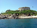
The island of Mamula

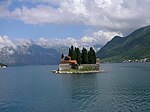
Sv. Đorđe (right) and Gospa od Škrpjela (left)
Monastery island of Sveti Đorđe against the backdrop of the Orjen

View over Kotor and the bay

Bay of Kotor


literature
- Miloš Milošević: Hajduci u Boki Kotorskoj. 1648-1718. Izvori za istoriju Crne Gore. Titograd 1988. ISBN 86-7215-014-7
- Pavao Butorac: Boka Kotorska nakon pada Mletačke republike do Bečkoga kongresa. 1797-1815. Zagreb 1938.
- Richard G. Plaschka: Inner front. Vol. 1. Between strike and mutiny. Vienna 1974. ISBN 3-7028-0077-8 (on the sailors' uprising of 1918)
- Danilo Kalezic, Slavko Mijuškovic, Mato Petrovic: Dvanaest vjekova mornarice Bokeljske mornarice. Monos, Beograd 1972. (Naval history of the Bay of Kotor)
Web links
- World Heritage site in the UNESCO database with extensive description ( English , French )
- Information and images to the Bay of Kotor (English)
- Private portal about Tivat and the Bay of Kotor (Serbo-Croatian, English, Czech)
Individual evidence
- ↑ Unesco World Heritage, Natural and Culturo-Historical Region of Kotor
- ↑ Aleksandar Joksimović, Mirko Djurović, Aleksander V. Semenov, Igor S. Zonn, Andrey G. Kostianoy: The Boka Kotorska Bay Environment . Springer, 2017, p. 421-424 .
- ↑ Aleksandar Joksimović, Mirko Djurović, Aleksander V. Semenov, Igor S. Zonn, Andrey G. Kostianoy: The Boka Kotorska Bay Environment . Springer, 2017, p. 425 .

Cultural heritage: natural and cultural-historical region of Kotors (1979) | Stećci - Medieval tombstones (2016) | Venetian Defense System of the 16th to 17th Centuries (2017)
Natural heritage: Durmitor National Park (1980)