
Prevlaka
Coordinates: 42 ° 23 ′ 57 ″ N , 18 ° 31 ′ 4 ″ E


Prevlaka is a peninsula in the extreme south of Croatia on the border with Montenegro . It forms the northern part of the entrance to the Montenegrin Bay of Kotor . After a dispute between the two states, it was mutually agreed to restore the border as it was before the outbreak of the war in Croatia .
geography
The Cyrillic word prevlaka means isthmus , it forms the road that leads into the Kotor Bay. The peninsula of the Dalmatian coast connects to the Croatian coastal landscape Konavle , and the interior of the bay at Herceg Novi , now Montenegrin. It forms an extension of the Bjelotina (up to 1125 m. I. J. ), which separates the two regions, a foothill of the Orjen mountain range of the Dinarides . The ridge of the Mandelovina connects to the Debeli Brijeg border pass , with a maximum height of 450 m. i. J. forms the Croatian-Montenegrin border and runs out on the one hand towards Cape Kobila and on the other hand the Prevlaka peninsula, the two right bank entrance headlands of the Bay of Kotor.
The Cape Oštra , at the southern tip of the peninsula, is the southernmost point of continental Croatia (further south are part of Palagruza ).
history
The peninsula has long been important for the excellent port of the Kotor Bay due to its strategic location.
On Prevlaka there is a fortress that was built in 1850 by the Austro-Hungarian troops. The well-preserved fortress shows deep bullet holes in various places. From the terrace you can see as far as Montenegro. To get to the Prevlaka Fortress you have to cross a park. A small train goes through the park to the entrance of the fortress or you can walk to the fortress via a well-developed path. Since the lower entrance is no longer open, you can only get into the interior via the higher entrance.
Before the civil war and the breakup of Yugoslavia , Prevlaka was the military base of the Yugoslav People's Army. For this reason, the peninsula between the newly created state of Croatia and the rest of Yugoslavia (Serbia and Montenegro) was highly controversial. For this reason, an independent UN mission was created in February 1996 , the United Nations Mission of Observers in Prevlaka (UNMOP). It ended in December 2002. Even with the successor Montenegro , the territorial claims have not been completely settled. In 2014 there was discussion about possible oil and gas deposits off the coast, the ownership of which is affected by the border at Cape Oštra.
Illustrations

Fortress on the Prevlaka peninsula
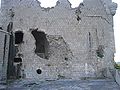
Detail with graffiti from the Serbian occupation 1991–1993

The prevlaka


See also
Web links
Cards:
- Map section in detail (PDF file, on un.org/…/unmop)
- Konavle - Turistička Karta - Tourist map. (on dominicus.malleotus.free.fr)
Individual evidence
- ↑ Article about the Prevlaka fortress ( memento of the original from August 16, 2013 in the Internet Archive ) Info: The archive link was inserted automatically and has not yet been checked. Please check the original and archive link according to the instructions and then remove this notice. , prevlaka.de
- ↑ United Nations Mission of Observers in Prevlaka (UNMOP) , on un.org (materials on the mission).