Mamula
| Mamula | ||
|---|---|---|
| Mamula | ||
| Waters | Bay of Kotor | |
| Geographical location | 42 ° 23 '43 " N , 18 ° 33' 30" E | |
|
|
||
| length | 200 m | |
| width | 200 m | |
| Highest elevation | 16 m | |
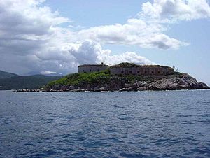
Mamula ( Cyrillic Мамула , or Ластавица / Lastavica ) is a small Montenegrin island in the Adriatic Sea , in the southwestern Montenegrin municipality of Herceg Novi . At the time of the rule of the Republic of Venice , the island was known as Rondina .
Mamula is strategically located at the entrance to the Bay of Kotor between the Prevlaka and Luštica peninsula.
This small island is almost circular, has a diameter of approx. 200 meters and rises up to 16 meters above sea level. It is located about 3.4 nautical miles (6.3 km) from Herceg Novi.
There is a fort on the island , which was built during the Austrian rule of General Lazarus von Mamula (Slavic Lazar Mamula ) in the middle of the 19th century. During the Second World War , the fort was used as a prison by Fascist Italy under Benito Mussolini from May 30, 1942 . The prison became known for the torture and cruelty suffered by the prisoners.
Nowadays the structural condition of the fort is deteriorating, but the island is a popular destination and has beautiful beaches. Most of the visitors come by boat from Herceg Novi.
In January 2016, the Orascom group announced plans to convert the fort into a luxury hotel.
See also
Individual evidence
- ↑ Former concentration camp on Adriatic island is to become a luxury hotel. In: sueddeutsche.de. January 17, 2016, accessed January 17, 2016 .


