
Vaalserberg
| Vaalserberg | ||
|---|---|---|
 View of the Vaalserberg from Aachen |
||
| height | 322.4 m above sea level NHN | |
| location | Netherlands , Belgium , Germany | |
| Coordinates | 50 ° 45 '17 " N , 6 ° 1' 15" E | |
|
||
| particularities | Highest mountain in the European Netherlands | |

The Vaalserberg is 322.4 m above sea level. NHN (Germany), 322.4 m NAP (Netherlands), or with 324.73 m OP (Belgium) the highest natural elevation in the European part of the Netherlands .
geography
The national borders between Belgium , Germany and the Netherlands run across the mountain ; the Dreiländereck ( Dutch: Drielandenpunt ) is exactly on the summit. The mountain is therefore partly in North Rhine-Westphalia , in the Dutch province of Limburg and in Wallonia , with the German-speaking community of Belgium also having a share.
The Vaalserberg is located about five kilometers southwest of Aachen city center or two kilometers south of Aachen- Vaalserquartier and just as far south of Vaals . Kelmis and Gemmenich are on the Belgian side .

history
Already in the late Middle Ages , the border of the former Aachen empire, fortified with the Aachener Landgraben , ran over the ridge of the Vaalserberg .
From 1839 to 1919, the Vaalserberg with the disputed area Neutral Moresnet as the fourth country was even a four-country corner (Vierlandenpunt) , which the name of the access road on the Dutch side - Viergrenzenweg - still reminds of. During the First World War , from 1915 to 1918, the high-voltage barrier on the Belgian-Dutch border extended over a length of 300 kilometers from the then four-country corner on the Vaalserberg to the Belgian North Sea coast at Knokke . The German invasion of Belgium via Gemmenich to Diksmuide in 1914 , which was associated with a great deal of suffering for the Belgian population, is commemorated by a memorial made of compressed war material on the southern tip of the Vaalserberg called Via Dolorosa . It was set up in 2014 on the centenary of the invasion by a non-profit peace initiative founded by women in 2011. Its members marched off parts of the route and collected money for the erection of the memorial sculptures.
The Gemmenicher Tunnel (called “Botzelaer Tunnel” in Belgium), an approximately 870 m long, double-track tunnel on the freight railway line from Aachen (Germany) to Tongeren (Belgium), runs around 120 m south of the border triangle in a north-east-south-west direction the Vaalserberg.
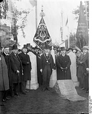
In 1928 a border monument was inaugurated on the German-Dutch-Belgian border. The monument consists of three stones that used to stand on the border. When the new border was drawn in 1926, the three stones were replaced by one. The municipality of Vaals then erected the old stones away from the border as a historical sight.
The mountain lost its status as the highest mountain in the Netherlands on October 10, 2010, when the Caribbean island of Saba with the 877 m high volcano Mount Scenery was incorporated into the Netherlands as a " special municipality " with the dissolution of the Netherlands Antilles .

Aachener Landgraben
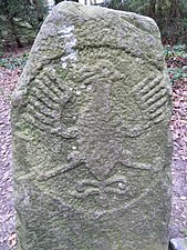
Aachen eagle stone

Gemmenich tunnel
Border Monument (1928)

Via Dolorosa memorial

.JPG)


Dreiländereck tourism

The combination of three countries and the tourist facilities there have made the Vaalserberg a very well-known tourist attraction in the Netherlands.
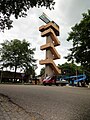
On the mountain stands the Balduin Tower (Tour Baudouin or Koning Boudewijntoren) , which is around 50 m high and named after the Belgian King Balduin . It is located on the Belgian side, 6 m from the German and 20 m from the Dutch border. From its viewing platform , which can be reached by elevator or on foot, there is a panorama of the surroundings
- Belgium via Gemmenich to the High Fens and Herver Land as well as the former Neutral-Moresnet near Kelmis and Plombières ,
- Germany between the Eifel and Aachen ,
- the Netherlands between Heerlen and Maastricht .
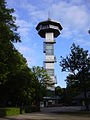
The counterpart on the Dutch side is the newly built Wilhelmina tower with a staircase. Wooden stairs and an elevator lead up; the top has a height of 353.5 m above Amsterdam level . From the “Skywalk” you have a good view, also through the frosted glass directly under your feet.
The tourist infrastructure includes several restaurants, fast food outlets, bicycle and hiking trails, an amusement park, a children's playground and the so-called “Dreiländereck-Labyrinth”, a hedge maze with additional doors and water fountains; The aim is to find the center, which takes an average of 45 minutes.

The highest point
Wilhelmina tower
Baldwin tower
.JPG)


Web links
Individual evidence
- ↑ Buiten de Fronten - België , Historical Report (ndl.) On the situation in Belgium in the First World War
- ↑ The Netherlands Antilles dissolved. In: Eurotopics . Federal Agency for Civic Education , October 11, 2010, archived from the original on July 20, 2011 ; Retrieved July 20, 2011 .