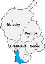
Bratislava bridgehead
The Bratislava or Bratislava bridgehead ( Slovakian Bratislavské predmostie , Czech Bratislavské předmostí , Hungarian Pozsonyi hídfő ) is an area in the extreme southwest of today's Slovakia , which - located south of the Danube and the capital Bratislava ( German Pressburg , Hungarian Pozsony ) - in the 20th century has repeatedly been the subject of diplomatic negotiations and assignments of territory.
First bridgehead 1920–1938

|

|
|
|
Border changes in today's Slovakia
|
Area of the Bratislava bridgehead, today Okres Bratislava V
|
The area belonged to the Kingdom of Hungary ( Moson County ) until 1918 and was part of the Habsburg Danube monarchy. After the establishment of Czechoslovakia in 1918 and the Trianon Peace Treaty (1920), the border between the Slovak part of the country and Hungary ran from the mouth of the March to the mouth of the Eipel along the Danube .
Only the place Petržalka (German Engerau , Hungarian Pozsonyligetfalu ) on the right bank of the Danube south of Bratislava formed a small Czechoslovak bridgehead south of the Danube as a result of this peace treaty , as many of the inhabitants of Bratislava owned land, workplaces and allotments here. In addition, the bridgehead bordered in the west on Lower Austria (municipality Wolfsthal ) and on Burgenland, which was ceded by Hungary to Austria in 1920 (municipality Kittsee ).
Second World War
In the Engerau area, the Czechoslovak armed forces built part of the Czechoslovak Wall , a fortified line of defense against a German attack, from the mid-1930s with the Engerau bridgehead . As a result of the Munich Agreement , Petržalka was annexed by the German Reich (since 1938: Gau Niederdonau ) together with the Bratislava suburb of Devín (German Thebes ) and its wide area .
Second bridgehead since 1946
The Czechoslovak delegation was at the Paris Peace Conference in 1946 , the enlargement of the bridgehead by the inclusion of five Hungarian towns ( Rusovce / Karlsburg / Oroszvár , Jarovce / Croatian Jahrndorf / Horvátjárfalu , Čunovo / Sarndorf / Dunacsúny , Rajka / Rage village and Bezenye / Pallersdorf / kroat. Bizonja ) in order to strategically protect the Slovak capital. The claimed area covered 145 km².
Finally, the area in question was divided by the peace conference, Czechoslovakia was awarded three of the five claimed Hungarian villages, so that Rajka and Bezenye remained with Hungary , while Jarovce, Rusovce and Čunovo came to Czechoslovakia. On October 15, 1947 then the assignment by Hungary and the handover took the awarded area of the former Czechoslovakia, which the Okres Bratislava V struck.
meaning
The area lay directly on the so-called "Iron Curtain" to Austria, which surrounded the ČSSR in the direction of its western neighbors from around 1952 and therefore remained a sparsely populated periphery between state borders and the Danube river despite its proximity to the capital Bratislava . Major infrastructure facilities were for the CMEA important railway line Bratislava-Hegyeshalom with the border crossing at Rajka and European routes E65 and E75 , the current highway D2 . The ČSSR built the controversial Danube power plant Gabčíkovo near Čunovo in the 1970s .
See also
Web links
- Slovak article on the enlargement of the bridgehead in 1947
- The area of the Bratislava bridgehead around 1873 (recording sheet of the state survey )
Individual evidence
- ^ Peter I. Hidas: Fairness for Hungary - Canada and the Making of the Hungarian Peace Treaty of 1947
Coordinates: 48 ° 3 ′ 36 ″ N , 17 ° 6 ′ 36 ″ E
