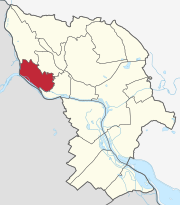
Devin
| Devin | |
|---|---|
| coat of arms | map |

|

|
| Basic data | |
| State : | Slovakia |
| Kraj : | Bratislavský kraj |
| Okres : | Bratislava IV |
| Region : | Bratislava |
| Area : | 13.98 km² |
| Residents : | 1,679 (Dec. 31, 2019) |
| Population density : | 120 inhabitants per km² |
| Height : | 158 m nm |
| Postal code : | 841 10 |
| Telephone code : | + 421-2 |
| Geographic location : | 48 ° 10 ′ N , 16 ° 59 ′ E |
| License plate : | BA, BL, BT |
| Kód obce : | 529401 |
| structure | |
| Community type : | district |
| Administration (as of November 2018) | |
| Mayor : | Ľubica Kolková |
| Address: | Miestny úrad Bratislava-Devín Kremeľská 39 84105 Bratislava |
| Website: | www.devin.sk |
| Statistics information on statistics.sk | |
Devín (German Theben , Hungarian Dévény ) is a district of Bratislava (Pressburg), which is located below the Castle Devín (Castle Theben) at the confluence of the March into the Danube and was an independent municipality until 1946.
This district is on the Austrian border. Through the March (Morova) it borders on the Lower Austrian municipality of Engelhartstetten in the Gänserndorf district and through the Danube to the Lower Austrian town of Hainburg an der Donau and the municipality of Wolfsthal in the Bruck an der Leitha district . However, there are no border crossings from there to Devín.
history
The history of the place is inextricably linked with that of the castle, but it was also mentioned in 1237 as "Villa Thebbyn". The city rights were confirmed in 1568 by the King of Hungary . For many centuries, until 1918, the castle and the rocks below marked the western border of Hungary, which was an internal border of the Habsburg monarchy from 1526 to 1918 . In the 16th century, numerous Croatians settled in the small town .
On October 20, 1938, Thebes and its surroundings were incorporated into the German Empire , Reichsgau Niederdonau / Lower Austria , in the course of the implementation of the Munich Agreement because of its German-speaking majority of the population . A geographical peculiarity was that the area of Thebes had no direct land connection with the empire, as there was no bridge over the border river March (as it is today). The transport connection was established by an extra-territorial bus line that ran four times a day and was operated by the Deutsche Reichsbahn between Theben and Engerau / Danube bridge (with connections to Vienna).
The German-speaking population was completely evacuated to the west in 1945 before the approaching Red Army , Devín was incorporated into the re-established Czechoslovakia from April 1945 . Because of the proximity to the border and the increased risk of flight, only selected citizens had the right to live. Since then, the population has gradually decreased: in 1991 Devín only had 779 inhabitants. The neighboring town of Devínska Nová Ves (Theben-Neudorf), which was also incorporated into Bratislava (Pressburg) in 1972, is more populated .
The so-called Theben Gate is named after Thebes , where the Danube, coming from Marchfeld in Lower Austria , enters the Hungarian Plain. This bottleneck is defined by the Thebener Kogel (Devínska Kobyla, 515 m) north and the Braunsberg (346 m) near Hainburg south of the Danube. The place is often affected by the Danube floods, for example the flood of the century in 2002.
Population development
| Ethnic structure | ||||||||
|---|---|---|---|---|---|---|---|---|
| year | Residents | Slovaks | German | Hungary | Others | |||
| 1880 | 1,655 | 327 | 1,179 | 65 | 84 | |||
| 1910 | 2,063 | 509 | 1.306 | 203 | 45 | |||
| 1921 | 1,974 | 810 | 983 | 56 | 125 | |||
| 1991 | 771 | 698 | 5 | 18th | 50 | |||
| 2001 | 884 | 813 | 3 | 13 | 55 | |||
| 2011 | 1,096 | 1,016 | 4th | 18th | 58 | |||
Attractions
On the road to Devínska Nová Ves there is a geological open-air museum in a small quarry at the foot of the castle , where you can see the various geological formations of the earth's history, for example the sea level in the Tertiary .
A memorial for the escape victims stands on the banks of the March.
Individual evidence
- ^ Course book of the Deutsche Reichsbahn 1941, timetable No. 1463 t.
- ^ Geological open-air museum in Devín. Regional association March-Thaya-Auen, accessed on June 21, 2017 .
Web links


