Vrakuňa
| Vrakuňa | |
|---|---|
| coat of arms | map |

|

|
| Basic data | |
| State : | Slovakia |
| Kraj : | Bratislavský kraj |
| Okres : | Bratislava II |
| Region : | Bratislava |
| Area : | 10.3 km² |
| Residents : | 20,120 (Dec. 31, 2019) |
| Population density : | 1,953 inhabitants per km² |
| Height : | 132 m nm |
| Postal code : | 821 07 |
| Telephone code : | + 421-2 |
| Geographic location : | 48 ° 9 ' N , 17 ° 13' E |
| License plate : | BA, BL, BT |
| Kód obce : | 529338 |
| structure | |
| Community type : | district |
| Administration (as of November 2018) | |
| Mayor : | Martin Kuruc |
| Address: | Miestny úrad Bratislava-Vrakuňa Šíravská 7 821 07 Bratislava |
| Website: | www.vrakuna.sk |
| Statistics information on statistics.sk | |
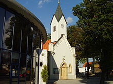
Vrakuňa (until 1948 Slovak "Verekne"; German Fragendorf , Hungarian Vereknye ) a formerly independent place and today's district in the east of Bratislava with around 19,000 inhabitants.
Description and history
The district consists of a mixture of the old village and modern high-rise buildings. To the north of the Little Danube , an arm of the Danube , there is a park ( Lesopark Vrakuňa ).
The place at that time was mentioned for the first time in 1279 and was called Verekne in Slovak until 1948 . On January 1, 1972, the place was incorporated into the city of Bratislava and has been one of the city districts ever since.
District structure
The district is divided into the following other smaller (unofficial) quarters:
- Dolné hony
Culture
See also: List of listed objects in Okres Bratislava II
Web links
Commons : Vrakuňa - collection of pictures, videos and audio files

