Mamalyha
| Mamalyha | ||
| Мамалига | ||

|
|
|
| Basic data | ||
|---|---|---|
| Oblast : | Chernivtsi Oblast | |
| Rajon : | Novoselytsia district | |
| Height : | 115 m | |
| Area : | Information is missing | |
| Residents : | 2,589 (2001) | |
| Postcodes : | 60364 | |
| Area code : | +380 3733 | |
| Geographic location : | 48 ° 15 ' N , 26 ° 35' E | |
| KOATUU : | 7323084301 | |
| Administrative structure : | 8 villages | |
| Address: | 60364 с. Мамалига | |
| Website : | https://www.mamalyha.com.ua/ | |
| Statistical information | ||
|
|
||
Mamalyha ( Ukrainian Мамалига ; Russian Мамалыга Mamalyga , Romanian Mămăliga ) is a village in the south of the Ukrainian Oblast Chernivtsi with about 2500 inhabitants (2006).

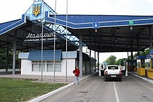
The 1771 first documentary mentioned village is situated 27 km east from Rajonzentrum Novoselytsia and 56 km east of the Oblastzentrum Chernivtsi on the banks of the Prut River in the border triangle Ukraine- Romania - Moldavia and has a border station on the railroad Chernivtsi-Ocniţa and a border crossing on the highway north 10 to Moldova.
local community
Mamalyha is the administrative center of the same name, 145.56 square kilometers of rural community in the southeast of the Rajon Novoselytsia to which even the villages Balkiwzi ( Балківці , ⊙ ) with about 1500 inhabitants, Dranyzja ( Драниця , ⊙ ) with about 1900 inhabitants, Koschuljany ( Кошуляни , ⊙ ) with about 1100 inhabitants, Stalniwzi ( Стальнівці ) with about 2100 inhabitants, Nehrynzi ( Негринці , ⊙ ) with about 750 inhabitants, Nesvoja ( Несвоя , ⊙ ) with about 1300 inhabitants and Podwirne ( Подвірне about 24 , ⊙ ) with about 24 , ⊙ ) .
See also
Web links
Individual evidence
- ^ Mamalyha on the official website of the Verkhovna Rada ; accessed on May 29, 2015 (Ukrainian)


