Chernivtsi Oblast
| Chernivtsi Oblast | |
|---|---|
|
Чернівецька область Chernivetska oblast Regiunea Cernăuți |
|

|

|
| Basic data | |
| Oblast center : | Chernivtsi |
| Official languages : | Ukrainian |
| Residents : | 908,500 (2014) |
| Population density : | 112.2 inhabitants per km² |
| in cities : | 40.8% |
| Area : | 8,097 km² |
| KOATUU : | 7300000000 |
| License plate : | CE, IE |
| Administrative division | |
| Rajons : | 11 |
| Cities : | 11 |
| managed by Oblast: | 2 |
| administered by Rajon: | 9 |
| Stadtrajone : | 3 |
| Urban-type settlements : | 8th |
| Villages: | 398 |
| Contact | |
| Address: | вул. Грушевського 1 58010 м. Чернівці |
| Website: | Official website |
| map | |
| Statistical information | |
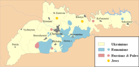
The Chernivtsi Oblast ( Ukrainian Чернівецька область Tscherniwezka oblast , Russian Черновицкая область Tschernowizkaja oblast , Romanian Regiunea Cernăuţi , German also Oblast Chernivtsi ) is an administrative unit of Ukraine in the southwest of the country. It has around 909,000 inhabitants (2014), including 20% Romanians . The oblast comprises three historical landscapes: the northern part of the Bukovina , the Herza area and the north of Bessarabia (the city of Chotyn and its surroundings). The capital is Chernivtsi , other cities are Chotyn and Storoschynez . In the south, the oblast borders Romania and the Republic of Moldova . Important rivers are the Dniester and Prut . In some Rajons the proportion of the Romanian population is still very high: Herza (Herța) 93.8%, Novoselyzja (Noua Suliță) 64.3%, Hlyboka (Adâncata) 51.4% and Storoschynez (Storojineț) 37.1%. (Source: 2002 census)
In the north-west the oblast borders on the Ivano-Frankivsk Oblast , in the north on the Oblasts Ternopil and Khmelnyzkyj, and for a short stretch in the east on the Vinnytsia Oblast . In the south, the oblast border forms the state border with Romania for long stretches , and with the Republic of Moldova on a shorter section in the southeast .
history
During the Middle Ages, the entire area belonged to the Principality of Moldova . In 1775 the Bukovina was annexed by Austria . Bessarabia was annexed to the Russian Empire in 1812 . The Herza area remained in the Principality of Moldova. After the First World War , the entire area belonged to Romania , which considered itself to be the successor state of the Moldovan principality. In 1940 Soviet troops occupy the region. In the following year Romania participated in the attack on the Soviet Union and came back into possession of the territory, but only until 1944.
The oblast itself was founded after the Soviet annexation of northern Bukovina on August 7, 1940 and comprised northern Bukovina and the former Romanian district of Hotin ( Chotyn ), the final borders were then determined on November 4, 1940 by a ukase, the southeast being the one Part of the Hotin district ceded to the Moldovan SSR .

Administrative division
The Chernivtsi Oblast is administratively divided into 11 Rajons and 2 cities directly subordinate to the Oblast administration. These are the cities Novodnistrovsk and the eponymous administrative center of the oblast, the city of Chernivtsi (Ukrainian Chernivtsi ).
Chernivtsi Oblast Rajons and their administrative centers
| Chernivtsi Oblast Rajons | ||
|---|---|---|
| German name | Ukrainian name | Administrative center |
| Chotyn district | Хотинський район Chotynskyj rajon |
Chotyn (city) |
| Herza district | Герцаївський район Herzajiwskyj rajon |
Herza (city) |
| Hlyboka district | Глибоцький район Hlybozkyj rajon |
Hlyboka (urban-type settlement) |
| Kelmenzi district | Кельменецький район Kelmenetskyj rajon |
Kelmenzi (urban-type settlement) |
| Kizman district | Кіцманський район Kizmanskyj rajon |
Kizman (city) |
| Novoselytsia district | Новоселицький район Novoselyzkyj rajon |
Novoselytsia (city) |
| Putyla district | Путильський район Putylskyj rajon |
Putyla (urban-type settlement) |
| Sastavna district | Заставнівський район Zastavnivskyj rajon |
Sastavna (city) |
| Sokyryany district | Сокирянський район Sokyrjanskyj rajon |
Sokyrjany (city) |
| Storozhynets district | Сторожинецький район Storoschynezkyj rajon |
Storoschynez (city) |
| Vyshnytsia district | Вижницький район Wyschnyzkyj rajon |
Vyshnytsia (city) |
Largest cities and settlements
| city | Ukrainian name | Russian name | Romanian name | Resident January 1, 2006 |
|---|---|---|---|---|
| Chernivtsi | Чернівці | Черновцы | Cernăuți | 243,474 |
| Storoschynez | Сторожинець | Сторожинец | Storojineț | 14,517 |
| Chotyn | Хотин | Хотин | Hotin | 10,595 |
| Novodnistrovsk | Новодністровськ | Новоднестровск | - | 10,268 |
| Sokyrjany | Сокиряни | Сокиряны | Secureni Târg | 9,780 |
| Krasnoyilsk | Красноїльськ | Красноильск | Crasna Ilschii | 9,295 |
| Hlyboka | Глибока | Глубокая | Adâncata | 9.226 |
| Sastavna | Заставна | Заставна | Zastavna | 8,595 |
| Novoselytsia | Новоселиця | Новоселица | Noua Suliță | 8,270 |
| Berehomet | Берегомет | Берегомет | Berhomete pe Siret | 8,120 |
| Kelmenzi | Кельменці | Кельменцы | Chelmenți | 7,800 |
| Kizman | Кіцмань | Кицмань | Cozmeni | 7,345 |
| Waschkiwzi | Вашківці | Вашковцы | Vășcăuți | 5,737 |
Demographics
| year | 1989 | 1990 | 1995 | 1998 | 2001 | 2005 | 2008 | 2012 | 2014 |
|---|---|---|---|---|---|---|---|---|---|
| Residents | 938,000 | 938,500 | 945,400 | 939,800 | 927,900 | 911.491 | 904.527 | 905.264 | 908,500 |
| nationality | Residents | 1989 (%) | 2001 (%) | Change (%) |
|---|---|---|---|---|
| Ukrainians | 689.100 | 70.8 | 75.0 | + 3.4% |
| Romanians | 114,600 | 10.7 | 12.5 | + 14.2% |
| Moldovans | 67,200 | 9.0 | 7.3 | −20.5% |
| Russians | 37,900 | 6.7 | 4.1 | −39.9% |
| Poland | 3,300 | 0.5 | 0.4 | −28.4% |
| Belarusians | 1,400 | 0.3 | 0.2 | −48.2% |
| Jews | 1,400 | 1.8 | 0.2 | −91.2% |
| native language | 2001 (%) |
|---|---|
| Ukrainian | 75.6 |
| Russian | 5.3 |
| Others ( Romanian etc.) | 19.1 |
Web links
Individual evidence
- ↑ Закон СССР от August 7, 1940 Об изменении и дополнении статей 13, 23 и 48 Конституции (Основного Закона) СССР
- ↑ Указ Президиума ВС СССР от November 4, 1940 об установлении границы между УССР и Молдавской Совиской Совисей Совисей Совесей Совисей
- ↑ The city was founded in 1973 and therefore has no Romanian name.
- ↑ http://www.ukrcensus.gov.ua/eng/
- ↑ http://www.ukrstat.gov.ua/
- ↑ http://2001.ukrcensus.gov.ua/eng/results/general/nationality/
- ↑ http://www.ukrcensus.gov.ua/eng/


