
Kherson Oblast
| Kherson Oblast | |
|---|---|
| Херсонська область / Chersonska oblast | |

|

|
| Basic data | |
| Oblast center : | Kherson |
| Official languages : | Ukrainian , Russian |
| Residents : | 1,072,500 (2014) |
| Population density : | 37.68 inhabitants per km² |
| in cities : | 60.3% |
| Area : | 28,461 km² |
| KOATUU : | 6500000000 |
| License plate : | BT, HT |
| Administrative division | |
| Rajons : | 18th |
| Cities : | 9 |
| managed by Oblast: | 3 |
| administered by Rajon: | 6th |
| Stadtrajone : | 3 |
| Urban-type settlements : | 31 |
| Villages: | 568 |
| Settlements : | 88 |
| Contact | |
| Address: | площа Свободи 1 73000 м. Херсон |
| Website: | Official website |
| map | |
 .svg) |
|
| Statistical information | |
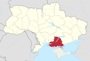
The Cherson Oblast ( Ukrainian Херсонська область / Chersonska oblast ; Russian Херсонская область / Chersonskaja oblast ) is one of 25 administrative units ( Oblasts of Ukraine ) in southern Ukraine . It has around 1.08 million inhabitants (2014). Its southern border is formed by the Black Sea in the western part , the Isthmus of Perekop connects the Oblast with the Crimea . To the east of it, the Sywasch forms a filigree network of bodies of water, islands and peninsulas that transition to the Sea of Azov . There are further transport connections to Crimea via the Chonhar peninsula. The oblast is bordered by Mykolaiv Oblast to the west , Dnipropetrovsk Oblast to the north and Zaporizhia Oblast to the east .
The oblast is traversed by the partially dammed Dnepr , which continues from Kherson in a wide delta interspersed with islands, before it flows over the Dnepr-Bug-Liman into the Black Sea. The North Crimean Canal branches off from the Dnieper and supplies the south of the oblast - and until 2014 the Crimean peninsula - with water. The Askanija-Nowa nature reserve in the oblast with its natural steppe vegetation is internationally known . The Oleschky Sands is the largest desert area in Ukraine in the oblast. In the southeast of the oblast, in the Sea of Azov, is Byryuchy Island .

Biggest cities
The capital of the oblast is the city of the same name, located on the north bank of the Dnieper, Kherson .
| city | Ukrainian name | Russian name | Resident January 1, 2006 |
|---|---|---|---|
| Kherson | Херсон | Херсон | 316.056 |
| Nowa Kachowka | Нова Каховка | Новая Каховка | 49,885 |
| Kachowka | Каховка | Каховка | 37,964 |
| Oleschky | Олешки | Алёшки | 24,737 |
| Henichesk | Генічеськ | Геническ | 20,890 |
| Skadovsk | Скадовськ | Скадовск | 19,185 |
| Hola Prystan | Гола Пристань | Голая Пристань | 15.192 |
| Beryslaw | Берислав | Берислав | 14,266 |
| Antonivka | Антонівка | Антоновка | 12,847 |
| Novotrojitske | Новотроїцьке | Новотроицкое | 11,259 |
| Tavriisk | Таврійськ | Таврийск | 11,120 |
| Kalanchak | Каланчак | Каланчак | 10,259 |
| Chaplynka | Чаплинка | Чаплинка | 10,227 |
| Novooleksiyivka | Новоолексіївка | Новоалексеевка | 10.157 |
| Biloserka | Білозерка | Белозерка | 9,777 |
| Welyka Lepetycha | Велика Лепетиха | Великая Лепетиха | 9.130 |
| Nowa Majatschka | Нова Маячка | Новая Маячка | 7,361 |
| Welyka Oleksandrivka | Велика Олександрівка | Великая Александровка | 7.158 |
| Komyshany | Комишани | Камышаны | 7.143 |
history
The Oblast was formed on March 30, 1944, it emerged from the Mykolaiv Oblast, which had existed since 1937 . This in turn was split off in 1937 from the Odessa Oblast, created in 1932 . Until 1920 the area was north of the Dnepr in the Cherson Governorate , the southern part in the Taurian Governorate .
Administrative division
The Kherson Oblast is administratively divided into 18 Rajons and 3 cities directly under the Oblast administration. These are the cities of Kachowka , Nowa Kachowka and the eponymous administrative center of the oblast, the city of Kherson .
Rajons of Kherson Oblast with their administrative centers

Demographics
| year | 1989 | 1990 | 1995 | 1998 | 2001 | 2005 | 2008 | 2012 | 2014 |
|---|---|---|---|---|---|---|---|---|---|
| Residents | 1,240,000 | 1,248,800 | 1,275,200 | 1,233,000 | 1,189,700 | 1,138,183 | 1,107,502 | 1,083,367 | 1,072,500 |
In the first years after independence, the population was still growing. At the end of the 1990s, the population in Kherson Oblast began to shrink, and the trend has continued to this day.
| nationality | Residents | 1989 (%) | 2001 (%) | Change (%) |
|---|---|---|---|---|
| Ukrainians | 961,600 | 75.7 | 82.0 | + 2.6% |
| Russians | 165,200 | 20.2 | 14.1 | −33.8% |
| Belarusians | 8,100 | 1.0 | 0.7 | −35.2% |
| Tatars | 5,300 | 0.2 | 0.5 | +150% |
| Moldovans | 4,100 | 0.5 | 0.4 | −25.6% |
| Armenians | 4,500 | 0.1 | 0.4 | + 280% |
| Crimean Tatars | 2,000 | 0.5 | 0.2 | −63.8% |
| native language | 1989 (%) | 2001 (%) |
|---|---|---|
| Ukrainian | 64.7 | 67.5 |
| Russian | 32.8 | 29.6 |
Web links
Individual evidence
- ↑ Державна служба статистики України. In: www.ukrstat.gov.ua. Retrieved November 28, 2016 .
- ↑ Україна перекрила канал надходження води до Криму , epravda.com.ua , April 26, 2014 (Ukrainian)
- ↑ Указ Президиума ВС СССР от 03/30/1944 об образовании Херсонской области в составе Украинской СР , Wikisource
- ↑ Archived copy ( memento of the original from March 25, 2012 in the Internet Archive ) Info: The archive link was inserted automatically and has not yet been checked. Please check the original and archive link according to the instructions and then remove this notice.
- ↑ http://www.ukrcensus.gov.ua/eng/
- ↑ http://www.ukrstat.gov.ua/
- ↑ http://2001.ukrcensus.gov.ua/eng/results/general/nationality/
- ↑ http://2001.ukrcensus.gov.ua/eng/results/general/language/
Oblast : Kharkiv | Kherson | Khmelnytskyi | Dnepropetrovsk | Donetsk | Ivano-Frankivsk | Kiev | Kirovohrad | Luhansk | Lviv | Mykolaiv | Odessa | Poltava | Rivne | Zaporizhia | Zhytomyr | Sumy | Ternopil | Transcarpathia | Cherkassy | Chernihiv | Chernivtsi | Wolyn | Vinnytsia
Cities with subject status: City of Kiev | City of Sevastopol 1
Autonomous Republic: Crimea 1
1 areas annexed by Russia
Beryslaw | Kherson | Henichesk | Hola Prystan | Kachowka | Nowa Kachowka | Oleschky | Skadovsk | Tavriisk
Antonivka urban-type settlements |
Archanhelske |
Askanija-Nowa |
Bila Krynytsya |
Biloserka |
Bryliwka |
Dnipryany |
Hornostayivka |
Ivanivka |
Kalanchak |
Kalynivske |
Karjerne |
Cossack |
Komyshany |
Glaze |
Lyubymivka |
Myrn |
Naddniprjanske |
Nowa Majatschka |
Nowoworonzowka |
Novooleksiyivka |
Novotrojitske |
Nyschni Sirohosy |
Rykowe |
Zelenivka |
Sywaske |
Tschaplynka |
Welyka Lepetycha |
Welyka Oleksandriwka |
Verkhniy Rohachyk |
Vysokopillia