
Buix
| Buix | ||
|---|---|---|
| State : |
|
|
| Canton : |
|
|
| District : | Porrentruy | |
| Municipal municipality : | Basse-Allaine | |
| Postal code : | 2925 | |
| former BFS no. : | 6777 | |
| Coordinates : | 569 348 / 259101 | |
| Height : | 383 m above sea level M. | |
| Area : | 8.23 km² | |
| Residents: | 462 (December 31, 2007) | |
| Population density : | 56 inhabitants per km² | |
| map | ||
|
||


Buix ( French [ bɥi ], in the local dialect [ (æ) bwɛ ]; Ger . Buchs ) is a village and a former political municipality in the Porrentruy district of the canton of Jura in Switzerland .
geography

Buix lies at 383 m above sea level. M. , eight kilometers north-northwest of the district capital Porrentruy (air line). The farming village extends in the valley of the Allaine in the northern Ajoie (German Elsgau ), near the border with France .
The area of the 8.2 km² former municipal area includes in the central part the 300 to 400 m wide valley, through which the Allaine flows, into which the dry valley La Grande Valle flows from the southwest near Buix . On both sides of the Allaine valley, the municipal area extends to the partially wooded heights of the Tafeljura , in the north to the Mont Renaud ( 506 m above sea level ), in the south-west to the Recet and the Neu Bois ( 543 m above sea level the highest elevation in the municipality) and to the south on the Sollery ( 526 m above sea level ). In 1997, 6% of the municipal area was accounted for by settlements, 50% for forests and woodlands and 44% for agriculture.
Buix includes the residential district Sous les Cantons , which adjoins to the north and is located on the Tafeljura plateau south of the Neu Bois at 511 m above sea level. M. lying hamlet Le Maira as well as several individual farms. Neighboring communities of Buix were Boncourt in the north, the French Courcelles in the northeast, Montignez in the east, Courtemaîche in the southeast, Bure in the south and Villars-le-Sec (also in France) in the west.
Population development
| year | 1770 | 1818 | 1850 | 1900 | 1950 | 2000 |
|---|---|---|---|---|---|---|
| Residents | 207 | 296 | 453 | 561 | 628 | 456 |
Source: Historical Lexicon of Switzerland
With 462 inhabitants (at the end of 2007), Buix was one of the smaller communities in the canton of Jura. 95.6% of the residents are French-speaking, 2.2% Spanish-speaking and 1.1% German-speaking (as of 2000). The population of Buix was 453 in 1850 and 561 in 1900. Since 1970 (617 inhabitants) there has been a significant population decline.
economy
Buix is still dominated by agriculture . Vines have been planted again since 1988 on a slope of the Allainetal southeast of Buix, which is optimally exposed to sunlight. Outside the agricultural sector there are few jobs in the village. Many workers (more than 60%) are therefore commuters and work mainly in Boncourt or in the Porrentruy region .
traffic
The former municipality is located on the main road 6 from Porrentruy via Boncourt to Belfort and Montbéliard in France . The A16 motorway , which is to be connected to both the Swiss national road network and the French motorway network by 2015, is expected to cross the municipal area in the west from 2012 and relieve Buix of today's heavy through traffic. On September 23, 1872 by the PD the railway Porrentruy-Delle opened with a station in Buix.
history
The village first appears as a bus in the documents in 1136 . The village name is from the Latin word buxus , boxwood due ', it is common in the surrounding woods. The community area was already inhabited in Roman times, which could be proven on the basis of the remains of a Roman estate.
Buix shared the checkered history of the Ajoie, which first came to the Duchy of Basel in 1271 . Both the Bellelay Monastery and the Lucelle Monastery owned land in the municipality . The village was under the Meieramt Bure from the 16th to the 18th century . From 1793 to 1815 Buix belonged to France and was initially part of the Département du Mont-Terrible , from 1800 connected to the Département Haut-Rhin . By decision of the Congress of Vienna , the place came to the canton of Bern in 1815 and on January 1, 1979 to the newly founded canton of Jura. The municipality was merged with Courtemaîche and Montignez to form the new municipality of Basse-Allaine with effect from January 1, 2009 .
Attractions
In the center of the village is the parish church of Saint-Maurice, built in the late neoclassical style in 1854 , the tower of which is from the previous building from the Middle Ages . The hamlet of Le Maira has preserved typical farmhouses from the mid-19th century. Here is the Saint-Joseph chapel, which was built in 1870. Another chapel, Notre-Dame-du-Sacré-Cœur (built in 1892), is in Valoin.

church

Church window

Bridge over the Allaine
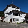
school
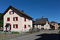
Cantonale route


Web links
- Information about Buix
- Dominique Prongué: Buix. In: Historical Lexicon of Switzerland .
Individual evidence
- ↑ Florence Cattin, Buix JU (Porrentruy) in: Dictionnaire toponymique des communes suisses - Lexicon of Swiss community names - Dizionario toponomastico dei comuni svizzeri (DTS | LSG) , Center de dialectologie, Université de Neuchâtel, Verlag Huber, Frauenfeld / Stuttgart / Vienna 2005 , ISBN 3-7193-1308-5 and Éditions Payot, Lausanne 2005, ISBN 2-601-03336-3 , p. 200.
All | La Baroche | Basse-Allaine | Beurnevésin | Boncourt | Bonfol | Bure | Clos du Doubs | Coeuve | Cornol | Courchavon | Courgenay | Courtedoux | Damphreux | Fahy | Fontenais | Grandfontaine | Haute-Ajoie | Lugnez | Porrentruy | Vendlincourt
Former parishes: Asuel | Bressaucourt | Buix | Charmoille | Chevenez | Courtemaîche | Damvant | Fregiécourt | Miécourt | Montenol | Montignez | Montmelon | Montvoie | Ocourt | Pleujouse | Réclère | Roche-d'Or | Rocourt | Seleute | Saint-Ursanne
Canton of Jura | Districts of the Canton of Jura | Municipalities of the Canton of Jura