
Courgenay JU
| JU is the abbreviation for the canton of Jura in Switzerland and is used to avoid confusion with other entries of the name Courgenay . |
| Courgenay | |
|---|---|
 |
|
| State : |
|
| Canton : |
|
| District : | Porrentruy |
| BFS no. : | 6784 |
| Postal code : | 2950 |
| Coordinates : | 576 328 / 250420 |
| Height : | 488 m above sea level M. |
| Height range : | 439–913 m above sea level M. |
| Area : | 18.44 km² |
| Residents: | 2331 (December 31, 2018) |
| Population density : | 126 inhabitants per km² |
| Website: | www.courgenay.ch |
 Courgenay |
|
| Location of the municipality | |
  |
|
Courgenay is a municipality in the Porrentruy district in the canton of Jura in Switzerland . The former German name Jennsdorf is no longer used today.
geography

Courgenay is 488 m above sea level. M. , 4 km east-southeast of the district capital Porrentruy (air line). The clustered village extends in a wide valley south of the Allaine , in the Ajoie (German Elsgau ), at the northern foot of the Chain Jura .
The area of the 18.4 km² municipal area includes the plain in the northern part, which gradually slopes slightly to the north to the Allaine. The north-western limit is the height of Cras d'Hermont (up to 537 m above sea level ). To the south, the municipality extends to the Jura ridge of the Lomont chain , which separates the Ajoie from the Doubs valley. Here is at 910 m above sea level. M. the highest elevation in the community. The northern slope of this chain is densely forested (including the Montagne d'Alle ) and is subdivided by several erosion valleys, most of which today do not show any perennial rivers. The western border lies in the dry valley Combe de Secroux , in the far east the area extends to Mont Terri . The municipal area is drained by the Pichou to the Allaine. In 1997, 8% of the municipal area was accounted for by settlements, 43% for forests and woodlands and 49% for agriculture.
Courgenay includes the place Courtemautruy , 541 m above sea level. M. at the north foot of the Lomont chain, as well as numerous individual farms. Courgenay's neighboring municipalities are Porrentruy , Alle , Cornol , Clos du Doubs and Fontenais .
population
With 2331 inhabitants (as of December 31, 2018) Courgenay is one of the large municipalities in the canton of Jura. 92.7% of the residents are French-speaking, 3.7% German-speaking and 1.3% Italian-speaking (as of 2000). In the first half of the 20th century, Courgenay's population remained relatively stable. A significant increase in population was registered between 1950 and 1970.
economy
| Population development | |
|---|---|
| year | Residents |
| 1850 | 1,098 |
| 1900 | 1,568 |
| 1910 | 1,498 |
| 1930 | 1,444 |
| 1950 | 1,511 |
| 1960 | 1,666 |
| 1970 | 1,954 |
| 1980 | 2.014 |
| 1990 | 2,088 |
| 2000 | 2,062 |
Courgenay developed from an agricultural to an industrial village in the second half of the 19th century. Important branches of industry were initially the manufacture of watch cases, cigars and jersey days. In 1983 an industrial and commercial zone was created on the eastern edge of the village. Today the mechanical engineering as well as precision engineering and automatic machine workshops offer most jobs. Thanks to the fertile soils in the area, agriculture is still very important today.
traffic
The community has good transport links. It is located on the main road from Porrentruy over the Les Rangiers pass to Delémont . The section of the A16 motorway from Delémont to Porrentruy, opened in 1998, runs east of the municipality and is to be connected to both the Swiss national road network and the French motorway network by 2015. The Courgenay exit and the north portal of the 4 km long Mont Terri tunnel are on the Cornol floor. Since opening, the through traffic through the village has decreased significantly.
On March 30, 1877, the Glovelier – Porrentruy railway was opened with a station in Courgenay. To the south of the village is the north portal of the 3 km long Mont Terri tunnel to Saint-Ursanne . Courgenay is also connected to public transport by the Postbus course from Porrentruy to Asuel .
history


Courgenay has a very long tradition of settlement. The area was already inhabited during the Neolithic , and there are also some traces from Roman times . The village was first mentioned in 1139 in a document from Pope Innocent II , who confirmed that the Lucelle monastery owned land in Corgennart . Later, numerous other spellings appear: Corginard , Corguinard , Corginay , Curgenard , Corgenne and Curgener , and in 1291 the German name Gennisdorf , which later changed to Jennsdorf. The interpretation of the place name is controversial and can be traced back to both the Burgundian personal name Gennard and the Germanic Gaginhard .
The village belonged to the Counts of Pfirt and came to the Duchy of Basel at the end of the 13th century . In the Thirty Years' War it was severely affected. This war also meant the end of the two villages Courtemblin and Courtary near Courgenay, some of which were abandoned during the Burgundian Wars and finally abandoned after the devastation of the Thirty Years' War. From the 16th to the 18th century Courgenay belonged to the Meieramt Alle . During the unrest from 1730 to 1740, the residents revolted against the prince-bishop's authorities under the leadership of Pierre Péquignat (1669–1740) , who came from the village . From 1793 to 1815 Courgenay belonged to France and was initially part of the Département du Mont-Terrible , from 1800 connected with the Département Haut-Rhin . Through the decision of the Congress of Vienna , the place came to the Canton of Bern in 1815 . Since January 1, 1979, it has belonged to the then newly founded Canton of Jura.
Courgenay became known throughout Switzerland during the First World War through Gilberte de Courgenay . She was the host's daughter at the Hôtel de la Gare and met the troops stationed in the Ajoie with particular warmth and charm. The folk song collector and soldier singer Hanns In der Gand (pseudonym of Ladislaus Krupski) has set a monument to her with his song Gilberte de Courgenay .
Attractions
- The current construction of the parish church of Notre-Dame-de-l'Assomption dates from 1854 to 1856 and shows a mixture of neo-Gothic and neo-Romanesque styles.
- In the village located megalithic Pierre-Percée , an approximately 3 m high monolith of limestone . This stone was erected around 5000 years ago and provided with a round hole, a so-called soul hole, in the middle.
- The village center still has some typical farmhouses from the 18th and 19th centuries. To the east of Courgenay is the Paplemont mill, built in 1691. The large mill wheel has been reconstructed.
photos
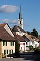
Le Bourg
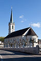
Eglise

Mairie

Memorial plaque railway workers

Megalith with a soul hole
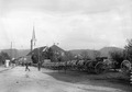
Eglise (1914-1918)


Web links
- Official website of the Municipality of Courgenay (French)
- Portrait of Courgenay (French)
- Dominique Prongué: Courgenay. In: Historical Lexicon of Switzerland .
Individual evidence
- ↑ Permanent and non-permanent resident population by year, canton, district, municipality, population type and gender (permanent resident population). In: bfs. admin.ch . Federal Statistical Office (FSO), August 31, 2019, accessed on December 22, 2019 .
All | La Baroche | Basse-Allaine | Beurnevésin | Boncourt | Bonfol | Bure | Clos du Doubs | Coeuve | Cornol | Courchavon | Courgenay | Courtedoux | Damphreux | Fahy | Fontenais | Grandfontaine | Haute-Ajoie | Lugnez | Porrentruy | Vendlincourt
Former parishes: Asuel | Bressaucourt | Buix | Charmoille | Chevenez | Courtemaîche | Damvant | Fregiécourt | Miécourt | Montenol | Montignez | Montmelon | Montvoie | Ocourt | Pleujouse | Réclère | Roche-d'Or | Rocourt | Seleute | Saint-Ursanne
Canton of Jura | Districts of the Canton of Jura | Municipalities of the Canton of Jura