
Saint-Ursanne
| Saint-Ursanne | ||
|---|---|---|
 |
||
| State : |
|
|
| Canton : |
|
|
| District : | Porrentruy | |
| Municipal municipality : | Clos du Doubs | |
| Postal code : | 2882 | |
| former BFS no. : | 6804 | |
| UN / LOCODE : | CH SUN | |
| Coordinates : | 578 618 / 246087 | |
| Height : | 440 m above sea level M. | |
| Area : | 11.46 km² | |
| Residents: | 689 (December 31, 2007) | |
| Population density : | 60 inhabitants per km² | |
| Website: | www.closdudoubs.ch | |
 Saint-Ursanne |
||
| map | ||
|
||


Saint-Ursanne ( French [ sɛ̃tyʀsan ], in local dialect [ (a) sĩt ɔˈʃan ]; German formerly St. Ursitz ) is a monastery , a historic small town and former political municipality in the Porrentruy district of the Swiss canton of Jura .
geography

Saint-Ursanne lies at 440 m above sea level. M. , eight kilometers southeast of the district capital Porrentruy (air line). The historic town extends in the narrow Doubs valley , on the right bank of the river, between the Jura ranges of the Lomont or Mont Terri in the north and the Clos du Doubs in the south.
The area of the 11.5 km², widely ramified former municipal area includes the Doubstal, which is deeply cut between the two Jura chains mentioned, in the area of the great arch of the Clos du Doubs . The valley floor of the river is usually only 100 to 200 m wide and surrounded by steep, mostly forested flanks, which in some places are criss-crossed by ledges. In the west the area extended down the valley to the Bellefontaine settlement , in the south to the slope of the Fin du Teck (up to 760 m above sea level ). To the north, the community area extended to the summit of Sur la Croix ( 789 m above sea level ) on the Lomont chain. In the east, Saint-Ursanne reached as far as the slope of the Mont-Russelin chain, where at 860 m above sea level. M. the highest point of the community was. Two exclaves also belonged to Saint-Ursanne: One comprised the steep slope of the Haute Côte to the right of the Doubs south of Montmelon, the other was on the eastern slope of the Chêtelat (up to 800 m above sea level ) to the left of the Doubs. In 1997, 6% of the municipal area was settled, 72% forest and woodland, 19% agriculture and about 3% was unproductive land.
Numerous individual farms belong to Saint-Ursanne. Neighboring communities were Seleute , Ocourt , Montmelon , Asuel , Montenol , Saint-Brais and Epauvillers .
population

With 689 inhabitants (at the end of 2008), Saint-Ursanne was one of the medium-sized communities in the canton of Jura. 91.2% of the residents speak French, 2.9% speak German and 2.0% speak Serbo-Croatian (as of 2000). The population of Saint-Ursanne increased continuously until 1960. A decline of over 40% has since been recorded as a result of high levels of emigration.
economy

The population of Saint-Ursanne is mainly employed in the secondary and tertiary sectors. The now abandoned settlement Bellefontaine goes back to the time of industrialization . There was an ironworks with a blast furnace there in the 18th and 19th centuries ; today there is only one power station left . In the industrial sector there was, among other things, a lime factory and a drop forge for non-ferrous metals. In the past, the manufacture of watch cases was still important, e.g. B. by the Stouder family until the mid-1970s. Today there are earning opportunities in the hospitality and hotel industry. Other jobs are provided by a workshop, carpentry, baker, dairy, post office and Raiffeisen branch, a kiosk, the tourist office, a youth hostel, a care home for the elderly and a home for the disabled. Saint-Ursanne is also the seat of the cantonal office for the environment. The Mont Terri rock laboratory is located next to the former lime works above the St.Ursanne train station.
traffic

Saint-Ursanne can be reached on the one hand via country roads and on the other hand, since the opening of the first section of the A16 motorway in 1998, via the exit of the same name from both Porrentruy and Delémont . The south portal of the Mont Terri tunnel (4 km) and the north portal of the Mont Russelin tunnel (3.5 km) are located in the municipality .
On March 30, 1877, the Glovelier – Porrentruy railway was opened with a train station east of Saint-Ursanne. The difficult topography in the Saint-Ursanne area required the construction of five tunnels and several bridges.
The city center is connected to the train station by a postbus course. Other bus lines run to Soubey and to La Motte near Ocourt .
Saint-Ursanne is located on the Trans-Swiss Trail hiking trail, the Via JuraRegio Delémont-Basel hiking trail. The Route du Jura Basel – Nyon exists for cyclists.
history

Saint-Ursanne is located at the place where the hermit Ursicinus , a companion of St. Columban , probably worked between 612 and 619 . The holy Wandregisel and other monks founded a monastery above the grave of Ursicinus, which was mentioned for the first time in a document in 849 as a cella ... in honorem Sancti Ursicini confessoris and belonged to the diocese of Besançon . In the 11th century a new abbey was built while the old monastery church was converted into a parish church. In 1139 the place is mentioned as Sancti Ursicini . In the 12th century, the abbey was converted into a canon monastery, which from 1210 was under the principality of Basel and covered the entire area of the Clos du Doubs. The medieval town that grew up around the monastery received market rights in 1338. The Basel earthquake in 1356 also caused damage in Saint-Ursanne.

From 1793 to 1815 Saint-Ursanne belonged to France and was initially part of the Département du Mont-Terrible , from 1800 it was linked to the Département Haut-Rhin . The monastery was secularized in 1803 and the former monastery church has been a parish church ever since.
As a result of the decision of the Congress of Vienna , the town came to the canton of Bern in 1815 , with the northern part of the Clos du Doubs being added to the Porrentruy district and the southern part to the Franches-Montagnes district. There were efforts to reunite the area of the former provost and to raise it to the status of a district, but this was rejected by the canton. On January 1, 2009, the unity of the Clos du Doubs was restored when Saint-Ursanne was united with Epauvillers , Epiquerez , Montenol , Montmelon , Ocourt and Seleute to form the new municipality of that name.
With the opening of the Glovelier - Porrentruy railway line in 1877, Saint-Ursanne stepped out of its isolation for the first time. The industrialization began and new houses were built outside the city walls.
On February 3, 1977, the Constitutional Council in the St-Ursanne Abbey passed the cantonal constitution of the new Canton of Jura.
Cityscape

After Delémont and Porrentruy, Saint-Ursanne is the third historical town in the canton of Jura, it has a medieval townscape, which is characterized by town houses from the 14th to 16th centuries. On the southern bank of the Doubs, in addition to an ensemble of fourteen houses that were built in 1918 for the Thécla workers, several more recent houses, the cemetery and, at the end of the valley, the local sewage treatment plant.
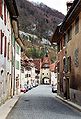
Medieval city center with city gate

Panorama from the castle hill

Collegiate church
The collegiate church, a Romanesque pillar basilica with a crypt under the choir, dates from the 12th to 14th centuries. From the 11th century abbey, capitals and parts of the north portal were included in the construction. The south portal (around 1200) in the Burgundian Romanesque style is one of the most important portals of this style in Switzerland. The nave, which was built a little later, already shows Gothic features , and the interior is largely from the 18th century. The earthquake of 1356 damaged the church tower of the monastery so badly that it later collapsed. The damage was not repaired until 1462 to 1464.
At the time of the turmoil of the Reformation, Saint-Ursanne remained loyal to the bishop of Basel, in contrast to most of the Jura. In 1792 the French occupied the city. On September 13, 1793, on the orders of the French commissioner, all bells were brought to Porrentruy as booty. Church decorations and consecrated vessels were also removed later. The bust of the saint remained in the city. The Benedictine monastery was dissolved.
On the mountain side, the early Gothic cloister from the 14th century closes off the church . In the former parish church of Saint-Pierre there are sarcophagi from the High Middle Ages.

church

Church and cloister of the former abbey
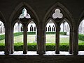
Cloister
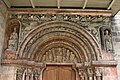
South portal of the church

Head of the College

Story about the collegiate church in St.Ursanne


Head of the pen:
- Burco or Bourquoard 1119–1139
- Billingus 1144-1173
- Hugo von Hasenburg 1173–1176 (Bishop of Basel)
- Philip of St. Ursanne 1176–1218
- Henre d'Asuel 1218-1256
- Erckenfried von Rixheim 1256–1283
- Werner Schaller 1283-1310
- Albert von Ehenheim 1310-1325
- Ulric Thiebaud d'Asuel 1324-1344
- Thiebaud d'Undervelier 1360-1364
- Jean Hennemann Cherbon 1364-1381
- Imer von Ramstein 1381–1382 (Bishop of Basel)
- Konrad Münch von Landskron 1382–1389 (Bishop of Basel)
- Jaques de Wattwyl 1390-1399 (Bishop of Casteries)
- Jean de Villar 1399-1400
- Jean de L'Isle 1400-1407
- Johann Dietrich Münch von Landskron 1407–1410
- Richard of St. Hippolyte 1410-1416
- Thiebad de Blamont 1416-1437
- Michel on the Rhine 1437–1440
- Jean Ludold d'Asuel 1441-1453
- Each to Rhine 1453–1457
- Pierre Textor 1457-1461
- Kaspar zu Rhein 1461–1479 (Bishop of Basel)
- Hartmann von Halwyl 1479–1506
- Johann Rudolf von Hallwyl 1506–1527 (coadjutor of Basel)
- Peter Reich von Reichenstein 1527–1540
- Johann Leonard von Gundelsheim 1540–1556
- Thomas Surgand 1556-1570
- Johann Georg von Lichtenfels 1570–1592
- Wilhelm Blarer von Wartensee 1592–1649
- Wolfgang Michel von Gall 1649–1651
- Thomas Henrici 1651-1660
- Frederic de Grandvillers 1660-1702
- Jean Conrad de Ferrette 1702-1709
- Jean-Jaques Beuret 1710-1732
- Francois-Joseph Bassand 1732–1741
- Fr. Ant. Klötzlin d'Altnach 1741–1762
- Jean-Germain Beuret 1763–1779
- Melchior-Joseph Tardy 1779–1789
- Jean-Jaques Keller 1789–1793 († 1802)
Hermitage
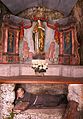
Grotto St-Ursanne with lying saint St. Ursicinus

Chapel of the Hermitage St-Ursanne

Front view of the chapel

Cross next to chapel and cave


The chapel of the Hermitage Saint-Ursanne stands on the cliff with furnishings from the 17th and 18th centuries. The cross belonged to a group of five crosses that can be traced back to Frédéric de Grandvillers. The cross next to the grotto is dated to 1816.
City gates
The medieval town has three city gates:
- Porte Saint-Pierre - east entrance with a bell tower from 1665
- Porte Saint-Paul (also Porte de Porrentruy) - west entrance rebuilt in 1664
- Porte Saint-Jean - in the south, with access to the Doubs bridge
Hotel de Ville
In the hall of the Hôtel de Ville (town house) the Gothic ribbed vault and round pillars have been preserved, the rest of the building dates from 1825.
Former castle
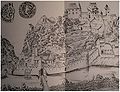
View from 1580

View around 1800


The ruins of the castle, first mentioned in a document in 1333, stand on the exposed rock north of the city. Previous construction work is to be assumed. Part of the former city wall was restored a few years ago. Stones from the former castle were used as building material for houses in the city. In 1828 the last stones were used to build a spinning mill.
Doubsbrücken

Doubs bridge and Porte Saint-Jean

Viaduct and new bridge over the Doubs


The four-arched stone bridge over the Doubs was built in 1728 and completely renovated in the mid-2010s using traditional craftsmanship. On it stands the statue of the bridge saint John of Nepomuk (1729) made of red sandstone .
Another bridge spans the Doubs above the city. This enables the local companies to be supplied with heavy trucks and relieves the city of through traffic.
Events
On the connecting road from Saint-Ursanne to the Col des Rangiers , a run for the European Hill Climb Championship is held once a year . The route length is 5169 m with a wide range of widths. The average gradient is 6.8% with a maximum of 10.8%. The start is in town, approx. 450 m from the (only) petrol station at 430 m above sea level. The destination is approx. 300 m before «Les Malettes» at 780 m above sea level. The neighboring Col de la Croix is also the destination of a hill climb.
A medieval festival takes place every two years. For three days, typical crafts and arts are presented.
Community partnerships
Since 1983 the community has been linked by a partnership with the French community of La Motte in Provence .
Personalities
- Wilhelmus Grimetre (1436–1519), priest, scribe and owner of manuscripts
- François Conrad de Grandvillers (1717–1806), Obervogt von Saint-Ursanne
- Andreas Gross (* 1952), politician
Web links
- Official website of Saint-Ursanne (French)
- Les Médiévales de St-Ursanne
- Jean-Paul Prongué: Saint-Ursanne (parish). In: Historical Lexicon of Switzerland .
- Jean-Paul Prongué: Saint-Ursanne (pen). In: Historical Lexicon of Switzerland .
Individual evidence
- ↑ a b Nicolas Pépin, Saint-Ursanne JU (Porrentruy) in: Dictionnaire toponymique des communes suisses - Lexicon of Swiss community names - Dizionario toponomastico dei comuni svizzeri (DTS | LSG) , Center de dialectologie, Université de Neuchâtel, Verlag Huber, Frauenfeld / Stuttgart / Vienna 2005, ISBN 3-7193-1308-5 and Éditions Payot, Lausanne 2005, ISBN 2-601-03336-3 , p. 786.
- ↑ [1] ( Page no longer available , search in web archives ) Info: The link was automatically marked as defective. Please check the link according to the instructions and then remove this notice. (PDF file; 31 kB) Fondation interjurassienne pour la statistique, Population résidante permanente des communes, selon le sexe et la nationalité, au 31 December 2008. Données officielles à utiliser pour tous les calculs financiers, accessed on February 5, 2010
- ↑ Gottlieb Binder: Orell Füßli's hiking guide. No. 343. Old nests. St-Ursanne. P. 16.
- ^ Karl Stehlin : The inscription above the church portal to Saint-Ursanne. Retrieved May 25, 2020 .
- ↑ The canton of Jura is ready. In: Walliser Bote, February 4, 1977, p. 3.
- ↑ Arts et monuments. République et Canton du Jura. Marcel Berthold, Bern 1989.
- ↑ Gottlieb Binder: Orell Füßli's hiking guide. No. 343. Old nests. St-Ursanne. P. 17.
- ↑ St-Ursanne et le Clos du Doubs. 1983, p. 45
- ↑ Gottlieb Binder: Orell Füßli's hiking guide. No. 343. Old nests. St-Ursanne. P. 27.
All | La Baroche | Basse-Allaine | Beurnevésin | Boncourt | Bonfol | Bure | Clos du Doubs | Coeuve | Cornol | Courchavon | Courgenay | Courtedoux | Damphreux | Fahy | Fontenais | Grandfontaine | Haute-Ajoie | Lugnez | Porrentruy | Vendlincourt
Former parishes: Asuel | Bressaucourt | Buix | Charmoille | Chevenez | Courtemaîche | Damvant | Fregiécourt | Miécourt | Montenol | Montignez | Montmelon | Montvoie | Ocourt | Pleujouse | Réclère | Roche-d'Or | Rocourt | Seleute | Saint-Ursanne
Canton of Jura | Districts of the Canton of Jura | Municipalities of the Canton of Jura