
Epiquerez
| Epiquerez | ||
|---|---|---|
 |
||
| State : |
|
|
| Canton : |
|
|
| District : | Porrentruy district | |
| Municipal municipality : | Clos du Doubs | |
| Postal code : | 2886 | |
| former BFS no. : | 6747 | |
| Coordinates : | 571 255 / 242104 | |
| Height : | 978 m above sea level M. | |
| Area : | 9.41 km² | |
| Residents: | 91 (December 31, 2007) | |
| Population density : | 10 inhabitants per km² | |
| map | ||
|
||


Epiquerez is a village and until December 31, 2008 was a municipality in the Porrentruy district of the canton of Jura in Switzerland .
With effect from January 1, 2009, it merged with Epauvillers , Montenol , Montmelon , Ocourt , Saint-Ursanne and Seleute to form the municipality of Clos du Doubs . With the merger, the former municipality was reallocated from the Franches-Montagnes district to the Porrentruy district .
geography
Epiquerez lies at 878 m above sea level. M. , nine kilometers northeast of the district capital Saignelégier ( linear distance ). The village extends on the broad ridge of the Jura range of the Clos du Doubs , around 450 m above the bottom of the Doubs , near the border with France .
The area of the 9.6 km² former municipal area includes a section of the Clos du Doubs. The central part of which forms the back of the Jura mountains, in the north of the ridge Lai Grétche is limited. The highest point of Epiquerez was 910 m above sea level. M. In the southern part of the municipality included the often very steep north face of Doubstals and handed in a narrow strip up to the opposite side of the valley below Montfavergier. In 1997, 2% of the municipal area was in settlements, 46% in forests and woodlands, 50% in agriculture and a little less than 2% was unproductive land.
The hamlets of Essertfallon ( 736 m above sea level ) on the southern slope of the Clos du Doubs and Chervillers ( 462 m above sea level ) just a little above the bottom of the Doubs, which forms an island here, as well as several individual farms belonged to Epiquerez . Neighboring communities of Epiquerez were Ocourt , Seleute , Epauvillers , Saint-Brais , Montfavergier and Soubey in the canton of Jura and Burnevillers in neighboring France.
population
With 91 inhabitants (at the end of 2007), Epiquerez was one of the smallest communities in the canton of Jura. 93.8% of the residents are French-speaking and 6.2% German-speaking (as of 2000). Since 1870 (then 285 inhabitants), the population of Epiquerez has decreased by around two thirds. In 1900 there were still 186 inhabitants.
economy
Epiquerez is a predominantly agricultural village with dairy farming , cattle breeding and some arable farming . There are hardly any jobs in the village outside of the primary sector. The few non-agricultural workers work abroad, mainly in Saint-Ursanne .
traffic
Epiquerez is far away from the larger thoroughfares. It is accessed by a spur road that branches off the cantonal road Saint-Ursanne - Soubey. A postbus course runs four times a day on this cantonal road, each making a detour up to Epiquerez and thus connecting the village to public transport.
history
The village was first mentioned in 1446 as Es Piquerez , derived from chez les Piquerez , a family named Piquerez . The place was under the provost of Saint-Ursanne. From 1793 to 1815 Epiquerez belonged to France and was initially part of the Département du Mont-Terrible , from 1800 it was linked to the Département Haut-Rhin . By decision of the Congress of Vienna , the place came to the canton of Bern in 1815 and on January 1, 1979 to the newly founded canton of Jura. In 1869 the Italian revolutionary Giuseppe Mazzini was granted the honorary citizenship of Epiquerez.
Attractions
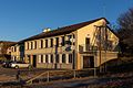
The townscape is dominated by numerous characteristic farmhouses from the 18th and 19th centuries. Ecclesiastically, Epiquerez was always dependent on Epauvillers . The water cisterns from the 18th century, which are grouped around the farm "Au Clos des Citernes", are worth mentioning. They have a depth of 6 - 8 m. The special thing about it is that the cisterns have roughly the same water level all year round. They are fed by so-called artesian springs. Where the millennia-old groundwater comes from has not yet been researched. Until the 1970s, French farmers used horse and cart to fetch water from these cisterns.
photos
school

old schoolhouse, then old chapel

Jurassic dialect

Farmhouse

Farmhouse


Web links
- Claude Rebetez: Epiquerez. In: Historical Lexicon of Switzerland .
La Chaux-des-Breuleux | Lajoux | Le Bémont | Le Noirmont | Les Bois | Les Breuleux | Les Enfers | Les Genevez | Montfaucon | Muriaux | Saignelégier | Saint-Brais | Soubey
Former parishes: Epauvillers | Epiquerez | Goumois | Le Peuchapatte | Les Pommerats | Montfavergier
Canton of Jura | Districts of Switzerland | Municipalities of the Canton of Jura