
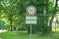
Les Enfers
| Les Enfers | |
|---|---|
 |
|
| State : |
|
| Canton : |
|
| District : | Franches-Montagnes |
| BFS no. : | 6745 |
| Postal code : | 2363 |
| Coordinates : | 570287 / 237.63 thousand |
| Height : | 955 m above sea level M. |
| Height range : | 515-1011 m above sea level M. |
| Area : | 7.12 km² |
| Residents: | 133 (December 31, 2018) |
| Population density : | 19 inhabitants per km² |
| Website: | readfers.ch |
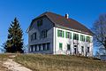
 Village center |
|
| Location of the municipality | |
  |
|
Les Enfers (French [lezɑ̃fɛr] , in the local dialect of the Freiberge [ez ɑ̃ˈfɛjɛ] ) is a municipality in the district of Freiberge in the Swiss canton of Jura . The former German name Die Hell or Inderhöll is no longer used today.
geography
Les Enfers is located at 955 m above sea level. M. , five kilometers northeast of the district capital Saignelégier ( linear distance ). The village extends on a flat Jura plateau of Freiberge (French Freiberge ), south of the Doubstals .
The area of the 7.1 km² municipal area includes a section of the gently undulating plateau of the Plateaujura, on which boggy, mostly above-ground drainage-free depressions alternate with limestone peaks . In the east, the area extends to the height of Sur le Begnon northeast of Montfaucon, which is 1022 m above sea level. M. forms the highest point of the municipality. In the north, the municipality covers the upper part of the steep southern flank of the Doubs, sometimes called Côte du Bouvier and Côte de Sciet , interspersed with rock faces (Les Rouges Roches) . In 1997, 2% of the municipal area was in settlements, 47% in forest and woodland, 50% in agriculture and a little less than 1% was unproductive land.
Les Enfers includes the hamlet of Cerniévillers ( 912 m above sea level ) on the slope of the Côte de Sciet high above the Doubs, as well as several individual farms. Neighboring municipalities to Les Enfers are Soubey , Saint-Brais , Montfaucon , Le Bémont and Saignelégier .
population
With 133 inhabitants (as of December 31, 2018), Les Enfers is one of the small communities in the canton of Jura. 84.6% of the residents are French-speaking, 13.9% German-speaking and 0.8% English-speaking (as of 2000). Since 1870 (then 287 inhabitants) the population of Les Enfers has halved. In 1900 194 inhabitants were counted.
economy
Les Enfers is a predominantly agricultural village with dairy farming and cattle breeding . Outside the primary sector there are only a few jobs in local small businesses. Many workers are therefore commuters. In the past, peat was cut in the peat soil of the Pâturage des Saignes .
traffic
The community is very well developed in terms of transport. It is 1 km from the main road from Delémont to La Chaux-de-Fonds , on the cantonal road from Montfaucon to Soubey . Les Enfers is served at certain times by the bus route from Glovelier to Saignelégier; the next stop to which each route takes is in the neighboring village of Montfaucon.
history
The village was first mentioned in 1330 under the name Au cruz des Enfers . The name means "deep place, sloping place"; the French enfers is based on the Latin infernu, "deeper located". What is meant by this is the valley flank of the Doubs, interspersed with rocks.
Les Enfers belonged to the dominion of Freiberge, which was subordinate to the Principality of Basel . From 1793 to 1815, Les Enfers belonged to France and was initially part of the Département du Mont-Terrible , from 1800 connected to the Département Haut-Rhin . By decision of the Congress of Vienna , the place came to the canton of Bern in 1815 and on January 1, 1979 to the newly founded canton of Jura.
The hamlet of Cerniévillers formed its own municipal municipality during the French period, but was united with Les Enfers in 1817.
Attractions
A small chapel is located on the northern edge of the Fin des Esserts plain, just before the steep drop into the Doubstal. In terms of the church, Les Enfers was always dependent on Montfaucon.
photos

Pré Morel (road to Soubey)

Wayside chapel

Freiberg farmhouse
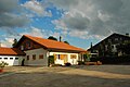
Primary school building
Entrance to the village from Les Enfers
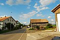
village street
Les Enfers


literature
- Claude Rebetez: Enfers, Les. In: Historical Lexicon of Switzerland .
Web links
Individual evidence
- ↑ Permanent and non-permanent resident population by year, canton, district, municipality, population type and gender (permanent resident population). In: bfs. admin.ch . Federal Statistical Office (FSO), August 31, 2019, accessed on December 22, 2019 .
- ↑ a b Lexicon of Swiss municipality names . Edited by the Center de Dialectologie at the University of Neuchâtel under the direction of Andres Kristol. Frauenfeld / Lausanne 2005, p. 256.
La Chaux-des-Breuleux | Lajoux | Le Bémont | Le Noirmont | Les Bois | Les Breuleux | Les Enfers | Les Genevez | Montfaucon | Muriaux | Saignelégier | Saint-Brais | Soubey
Former parishes: Epauvillers | Epiquerez | Goumois | Le Peuchapatte | Les Pommerats | Montfavergier
Canton of Jura | Districts of Switzerland | Municipalities of the Canton of Jura