
Le Noirmont
| Le Noirmont | |
|---|---|
 |
|
| State : |
|
| Canton : |
|
| District : | Franches-Montagnes |
| BFS no. : | 6754 |
| Postal code : | 2340 |
| UN / LOCODE : | CH NOI |
| Coordinates : | 563520 / 230 566 |
| Height : | 971 m above sea level M. |
| Height range : | 504–1179 m above sea level M. |
| Area : | 20.39 km² |
| Residents: | 1847 (December 31, 2018) |
| Population density : | 91 inhabitants per km² |
| Website: | www.noirmont.ch |
 Le Peu-Péquignot |
|
| Location of the municipality | |
  |
|
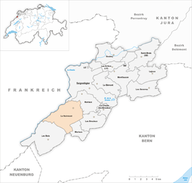
Le Noirmont is a municipality in the Franches-Montagnes district in the canton of Jura in Switzerland . The former German name Schwarzenberg is no longer used today.
geography

Le Noirmont is at 971 m above sea level. M. , five kilometers southwest of the district capital Saignelégier ( linear distance ). The village is located on the Jura plateau of Freiberge (French Freiberge ), right on the edge of the deep valley of the Doubs .
The area of the 20.5 km² municipal area comprises a section of the gently undulating plateau of the Plateaujura, on which boggy, mostly above-ground drainage-free depressions alternate with limestone peaks . The entire southern part of the municipality is covered by extensive Jura pastures with large spruce trees standing individually or in groups, as well as forest areas in between. The highest point of Le Noirmont is on the Point de Vue ridge at 1170 m above sea level. M. In the extreme south of the area dates back to the valley of La Chaux-d'Abel . The north-western border is formed by the canyon-like course of the Doubs, which is cut into the Plateau Jura; the approx. 500 m high valley slope is densely forested and is criss-crossed by numerous ledges and crests ( Grosse Côte , Roche Gipois ). The northern boundary is on the striking Arête des Sommêtres ridge (with the Spiegelberg ruins) and at the height of the Spiegelberg ( 1108 m above sea level ). In 1997, 5% of the municipal area was in settlements, 43% in forests and woodlands, 51% in agriculture and a little less than 1% was unproductive land.
Le Noirmont includes the hamlets of Le Peu-Péquignot ( 995 m above sea level ), Le Creux-des-Biches ( 1012 m above sea level ) and Les Barrières ( 1000 m above sea level ), all on the plateau of the Located in the Freiberg Mountains, Les Côtes ( 830 m above sea level ) on the slope high above the Doubs, as well as numerous individual farms spread across the Jura meadows. Neighboring communities of Le Noirmont are Saignelégier , Muriaux , Les Breuleux and Les Bois in the canton of Jura, Saint-Imier in the canton of Bern and Charquemont and Charmauvillers in neighboring France .
population
| Population development | |
|---|---|
| year | Residents |
| 1850 | 1544 |
| 1870 | 1892 |
| 1900 | 1681 |
| 1910 | 1852 |
| 1930 | 1596 |
| 1950 | 1455 |
| 1960 | 1559 |
| 1970 | 1516 |
| 1980 | 1505 |
| 1990 | 1515 |
| 2000 | 1561 |
With 1847 inhabitants (as of December 31, 2018), Le Noirmont is one of the larger municipalities in the canton of Jura. 91.3% of the residents are French-speaking, 3.0% German-speaking and 1.9% Portuguese-speaking (as of 2000). The population of Le Noirmont reached its highest level as early as 1870. In the first half of the 20th century in particular, there was a significant decline in the number of inhabitants. There have been only minor fluctuations since 1950.
economy
Le Noirmont's working life shifted from agriculture to industry during the 19th century . The manufacture of clocks was the most important branch of industry in the village for a long time, but today it is limited to a few smaller factories and the mechanics branch has taken its place. In the Fromagerie des Franches-Montagnes is Tête de Moine , an important type of cheese of the region produces. Below La Goule on the Doubs, there is an electricity company that supplies large parts of the Franches-Montagnes and Vallon de Saint-Imier with energy. The Jurassic rehabilitation center for heart and vascular diseases has been on Roc-Montès since 1985. Work is carried out consistently according to given daily schedules, with the main topics being devoted to sport, nutrition and relaxation. The center offers physical and mental preparation for reintegration into society for heart valve, by-pass and stent patients.
However, the hamlets are still dominated by agriculture and focused on dairy farming and cattle breeding .
traffic

The community is very well developed in terms of transport. It is located on the main road from Delémont to La Chaux-de-Fonds . On December 7, 1892, the Saignelégier – La Chaux-de-Fonds railway was opened with a station in Le Noirmont and another in Le Creux-des-Biches. The inauguration of the Tramelan-Breuleux-Noirmont railway took place on December 16, 1913. The two railway lines La Chaux-de-Fonds-Saignelégier and Tramelan-Le Noirmont have been operated by the Chemins de fer du Jura (CJ) since 1944 .
In recent years, the Chemins de fer du Jura network, which extends from Le Noirmont in all three directions, has run every hour. This hourly service applies to the route to La Chaux-de-Fonds, with connections in all directions, for the route to Glovelier, with a connection to Delémont / Basel and for the route to Tavannes with a connection to Biel. The Chemins de fer du Jura routes around Le Noirmont are meter gauge routes.
history
The roots of Le Noirmont go back to the exemption of the Franches-Montagnes from the usual taxes, which were recorded in a file by the Basel Prince-Bishop Imier von Ramstein in 1384. Le Noirmont is mentioned for the first time in 1397, the name is derived from La Noire Montagne , as the formerly densely forested area of the Freiberg Mountains was called. The village belonged to the dominion of Freiberge, which was subordinate to the Principality of Basel .
From 1793 to 1815, Le Noirmont belonged to France and was initially part of the Département du Mont-Terrible , from 1800 it was linked to the Département Haut-Rhin . By decision of the Congress of Vienna , the place came to the canton of Bern in 1815 and on January 1, 1979 to the newly founded canton of Jura.
Two people were injured in the air raid on Le Noirmont by the US Air Force in October 1944.
Attractions
The old parish church of Saint-Hubert was built in 1513 as a three-aisled basilica in the flamboyant style. The main altar from 1720 probably comes from the Bellelay monastery . Until this church building, Le Noirmont was dependent on the parish of Montfaucon . The modern church was built in 1969 according to plans by Father Dumas. There is a chapel in the hamlet of Les Côtes and a private school in the buildings of the former orphanage. 2019 was Schaukäserei the Fromagerie des Franches-Montagnes opened.
photos

St-Hubert church tower

Old St-Hubert Church

Primary school building

Secondary school house
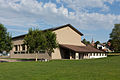
gym
post Office

Rue de Rauracie

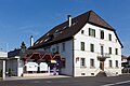
Hotel-Restaurant Georges
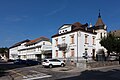
Parish hall

Rue du 23 juin
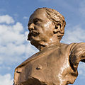
National Councilor Casimir Folletête

Le Noirmont Clinic


Web links
- Website of the municipality of Le Noirmont
- François Kohler: Noirmont, Le. In: Historical Lexicon of Switzerland .
Individual evidence
- ↑ Permanent and non-permanent resident population by year, canton, district, municipality, population type and gender (permanent resident population). In: bfs. admin.ch . Federal Statistical Office (FSO), August 31, 2019, accessed on December 22, 2019 .
- ↑ Monika Gerlach: cheese dairy for 4 million kilos. In: schweizerbauer.ch . April 13, 2019, accessed April 18, 2019 .
La Chaux-des-Breuleux | Lajoux | Le Bémont | Le Noirmont | Les Bois | Les Breuleux | Les Enfers | Les Genevez | Montfaucon | Muriaux | Saignelégier | Saint-Brais | Soubey
Former parishes: Epauvillers | Epiquerez | Goumois | Le Peuchapatte | Les Pommerats | Montfavergier
Canton of Jura | Districts of Switzerland | Municipalities of the Canton of Jura