
Epauvillers
| Epauvillers | ||
|---|---|---|
 |
||
| State : |
|
|
| Canton : |
|
|
| District : | Franches-Montagnes | |
| Municipal municipality : | Clos du Doubs | |
| Postal code : | 2885 | |
| former BFS no. : | 6746 | |
| Coordinates : | 575 562 / 242856 | |
| Height : | 696 m above sea level M. | |
| Area : | 8.43 km² | |
| Residents: | 136 (December 31, 2007) | |
| Population density : | 16 inhabitants per km² | |
| map | ||
|
||


Until December 31, 2008, Epauvillers was a municipality in the Franches-Montagnes district of the canton of Jura in Switzerland .
With effect from January 1, 2009, it merged with Epiquerez , Montenol , Montmelon , Ocourt , Saint-Ursanne and Seleute to form the municipality of Clos du Doubs . With the merger, the former municipal area was divided from the Freiberge district into the Pruntrut district .
geography
Epauvillers is 696 m above sea level. M. , twelve kilometers northeast of the district capital Saignelégier ( linear distance ). The village extends in a hollow on the southern slope of the Jura range of the Clos du Doubs , around 230 m above the bottom of the Doubs .
The area of the 8.4 km² former municipal area includes a section of the Clos du Doubs. To the south, the area extends over the foothills, which drop very steeply to the Doubs ( Sous les Roches ), to the deeply cut river. In the north, the wide ridge of the Fin du Teck ( 892 m above sea level ) and the Bois de Villers (at 917 m above sea level, the highest point in the municipality) belonged to Epauvillers. The eastern boundary was the Chêtelat rocky outcrop ( 841 m above sea level ). In 1997, 3% of the municipal area was in settlements, 43% in forests and woodlands, 53% in agriculture and a little less than 1% was unproductive land.
Several individual farms belonged to Epauvillers. Neighboring communities of Epauvillers were Seleute , Saint-Ursanne , Montenol , Montmelon , Saint-Brais and Epiquerez .
population
With 136 inhabitants (at the end of 2007), Epauvillers was one of the small communities in the canton of Jura. 98.0% of the residents are French-speaking and 2.0% German-speaking (as of 2000). Since 1888 (then 320 inhabitants) the population of Epauvillers has halved. In 1900 there were still 251 inhabitants.
economy
Epauvillers is a predominantly agricultural village with dairy farming , cattle breeding and some arable farming . There are hardly any jobs in the village outside of the primary sector. Many workers are therefore commuters and work in Saint-Ursanne.
traffic
The former municipality is located away from the major thoroughfares on a cantonal road that leads from Saint-Ursanne to Soubey . There is a PostBus course on this route that connects Epauvillers to public transport.
history
Epauvillers was first mentioned as Villare in 1139 in a document from Pope Innocent II as the property of the Saint-Ursanne monastery. In the following years the names Vilaire (1175), Vilario (1173), Vilers (1210) and in the 16th century Haut-Villers appear . Only at the beginning of the 18th century did the name change to Epauvillers. The place was under the provost of Saint-Ursanne. From 1793 to 1815 Epauvillers belonged to France and was initially part of the Département du Mont-Terrible , from 1800 it was linked to the Département Haut-Rhin . By decision of the Congress of Vienna , the place came to the canton of Bern in 1815 and on January 1, 1979 to the newly founded canton of Jura.
Attractions
The Saint-Arnoux church was rebuilt in the 17th century, later rebuilt and renovated for the last time in 1965. The townscape is dominated by characteristic farmhouses from the 18th and 19th centuries. The home-style schoolhouse dates from 1928.
photos

Partial view of Epauvillers

Saint-Arnoux church

Primary school building
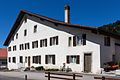
Farmhouse (1783)


Web links
- Claude Rebetez: Epauvillers. In: Historical Lexicon of Switzerland .
La Chaux-des-Breuleux | Lajoux | Le Bémont | Le Noirmont | Les Bois | Les Breuleux | Les Enfers | Les Genevez | Montfaucon | Muriaux | Saignelégier | Saint-Brais | Soubey
Former parishes: Epauvillers | Epiquerez | Goumois | Le Peuchapatte | Les Pommerats | Montfavergier
Canton of Jura | Districts of Switzerland | Municipalities of the Canton of Jura