Ocourt
| Ocourt | ||
|---|---|---|
| State : |
|
|
| Canton : |
|
|
| District : | Porrentruy | |
| Municipal municipality : | Clos du Doubs | |
| Postal code : | 2889 | |
| former BFS no. : | 6798 | |
| Coordinates : | 572 737 / 244 722 | |
| Height : | 424 m above sea level M. | |
| Area : | 11.63 km² | |
| Residents: | 134 (December 31, 2007) | |
| Population density : | 12 inhabitants per km² | |
|
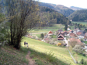
Ocourt in spring |
||
| map | ||
|
|
||
Ocourt ( French [ o (ː) kuːʀ ], in the local dialect [ oˈkwe ]) is a village and a former political municipality in the Porrentruy district of the Swiss canton of Jura .
geography
Ocourt is 424 m above sea level. M. , seven kilometers south of the district capital Porrentruy (beeline). The small farming village extends in the 500 m wide valley of the Doubs , in the chain Jura west of Saint-Ursanne .
The area of the 11.6 km² former municipal area includes the valley of the Doubs, which is deeply cut between two Jura chains in the area of the Clos du Doubs with a flat valley floor 200 to 500 m wide. The mostly steep, mostly forested flanks are partly criss-crossed by rock faces. In the south the area extended to the Clos du Doubs chain (on Lai Grétche 885 m above sea level ). To the north, the community area extended to the Lomont chain and reached Les Chainions at 909 m above sea level. M. the highest point of Ocourt. The southern slope of this Jura chain has two deep erosion valleys, with the 790 m high Montagne de Valbert in between . In 1997, 3% of the municipal area was in settlements, 56% in forests and woodlands, 39% in agriculture and a little less than 2% was unproductive land.
The hamlet of La Motte ( 425 m above sea level ) in the Doubstal on the border with France , the farm settlements of Monturban ( 581 m above sea level , on a terrace high above the Doubs) and Valbert ( 757 m above sea level ) belonged to Ocourt . in an anticline valley of the Lomont chain) as well as several individual farms. Neighboring communities of Ocourt were Epiquerez , Seleute , Saint-Ursanne , Montmelon , Courgenay , Fontenais and Bressaucourt in the canton of Jura and Montancy in neighboring France.
population
With 134 inhabitants (at the end of 2007), Ocourt was one of the small communities in the canton of Jura. 77.3% of the residents are French-speaking, 22.0% German-speaking and 0.8% Spanish-speaking (as of 2000). The population of Ocourt was 381 in 1850, compared to 244 in 1900. Since then, another significant decrease in population has been recorded.
economy
Ocourt is a village dominated by agriculture , where cattle and dairy farming predominate, there is also fruit growing . The place offers only a few jobs outside of the primary sector. Those who do not work in agriculture mainly work in Saint-Ursanne.
traffic
The municipality is located far away from the major thoroughfares on a cantonal road that runs from Saint-Ursanne along the course of the Doubs to Saint-Hippolyte in France. Ocourt is connected to public transport by a postbus course that runs between Saint-Ursanne and the border at La Motte.
history
The village is first mentioned in a copy from 1179 of a document from 1139 as Oscurt . The name is probably a composition of an Old High German personal names may Hoso , Ozo or similar.. And Rome. Corte , yard, estate, 'the hamlet as a basic word, probably under the Germanic influence, contrary to Roman composites occurs typical word order to the end .
From 1793 to 1815 Ocourt belonged to France and was initially part of the Département du Mont-Terrible , from 1800 connected with the Département Haut-Rhin . By decision of the Congress of Vienna , the place came to the canton of Bern in 1815 and on January 1, 1979 to the newly founded canton of Jura. In 1882, the former municipality of Montvoie, consisting only of individual farms, joined the municipality of Ocourt. This in turn was merged on January 1, 2009 with Epauvillers , Epiquerez , Montenol , Montmelon , Saint-Ursanne and Seleute to form the new municipality of Clos du Doubs .
Attractions
- Far outside the village in the Doubs valley is the parish church of Saint-Valbert, which was built in 1641 and has a painted wooden ceiling from the 17th century.
- On the southern slope of the Lomont range are the ruins of Montvoie Castle, which was a fief of the Principality of Basel . Today the remains of the keep and a palace from the 10th and 11th centuries can still be seen.
Web links
- Ocourt (French)
- Dominique Prongué: Ocourt. In: Historical Lexicon of Switzerland .
Individual evidence
- ↑ a b Nicolas Pépin / Andres Kristol, Ocourt JU (Porrentruy) in: Dictionnaire toponymique des communes suisses - Lexicon of Swiss community names - Dizionario toponomastico dei comuni svizzeri (DTS | LSG) , Center de dialectologie, Université de Neuchâtel, Verlag Huber, Frauenfeld / Stuttgart / Vienna 2005, ISBN 3-7193-1308-5 and Éditions Payot, Lausanne 2005, ISBN 2-601-03336-3 , p. 675.


