
Réclère
| Réclère | ||
|---|---|---|
 |
||
| State : |
|
|
| Canton : |
|
|
| District : | Porrentruy | |
| Municipal municipality : | Haute ajoie | |
| Postal code : | 2912 | |
| former BFS no. : | 6801 | |
| Coordinates : | 561106 / 247 413 | |
| Height : | 590 m above sea level M. | |
| Area : | 6.19 km² | |
| Residents: | 191 (December 31, 2007) | |
| Population density : | 31 inhabitants per km² | |
| map | ||
|
||


Réclère ( French [ ʀɛ̝klɛ̝ʀ ], in local dialect [ (a) reˈʃer ]) is a village and a former political municipality in the Porrentruy district of the Swiss canton of Jura and is now part of the municipality of Haute-Ajoie .
geography
Réclère lies at 590 m above sea level. M. , twelve kilometers west-southwest of the district capital Porrentruy (air line). The former street line village extends on the northern slope of a valley at the northern foot of the Jura range of the Lomont , in the west of the Ajoie (German Elsgau ).
The area of the 6.2 km² former municipal area includes the one kilometer wide high valley of Réclère, which does not show any surface rivers. In the north, the depression is bounded by the hills of Perchet ( 664 m above sea level ) and La Clef ( 644 m above sea level ). To the south, the municipality reached the ridge of the Lomont chain, which is relatively low here, which separates Réclère from the Doubs valley. The highest point of Réclère is on the forest height La Montagne with 790 m above sea level. M. achieved. In 1997, 4% of the municipal area was accounted for by settlements, 39% for forests and woodlands and 57% for agriculture.
Several individual farms belong to Réclère. Neighboring communities of Réclère were Damvant , Grandfontaine and Roche-d'Or in the canton of Jura and Vaufrey in neighboring France .
population
With 191 inhabitants (at the end of 2007) Réclère was one of the small communities in the canton of Jura. 84% of the residents are French-speaking and 16% German-speaking (as of 2000). The population of Réclère was 321 in 1850 and 362 in 1900. As a result of strong emigration, the number of inhabitants has decreased markedly in the course of the 20th century.
economy
Réclère is still a predominantly agricultural village. The local small businesses and tourist facilities also offer some jobs. However, many workers are commuters and work in the Porrentruy region .
traffic
The former municipality is located on the cantonal road from Porrentruy across the border crossing from Damvant to Pont-de-Roide-Vermondans in France. A side road leads over the Lomont chain into the Doubstal to Vaufrey. Réclère is connected to public transport through the Postbus course, which runs from Porrentruy to Damvant.
history
The village is first mentioned around 1150 as Resclires ; the name is likely to be a variant of the common freelance word çhériere / éçhè / réçhè , clearing '. In 1283 Réclère came under the rule of Roche-d'Or . From the 16th to the 18th century it belonged to the Meieramt Chevenez , which was dependent on the Principality of Basel . In 1766, numerous houses fell victim to a village fire. From 1793 to 1815 Réclère belonged to France and was initially part of the Département du Mont-Terrible , from 1800 connected with the Département Haut-Rhin . Through the decision of the Congress of Vienna , the municipality came to the canton of Bern in 1815 , and finally to the newly founded canton of Jura on January 1, 1979. On January 1, 2009, it was united with Chevenez, Damvant and Roche-d'Or to form the new municipality of Haute-Ajoie .
Attractions
The parish church of Saint-Germain-et-Protais was built in 1860 in the neoclassical style; the stained glass windows are from 1969. Until 1802 Réclère belonged to the parish of Damvant . Opposite the church is the school house built at the beginning of the 20th century. In the town center there are still numerous characteristic farmhouses with arched barn doors from the 19th century.
A special attraction is the Réclère cave (French: Grottes de Réclère). The stalactite cave , discovered at the end of the 19th century, is now open to tourists and can be visited on a 1.5 km long cave path. Another tourist attraction is the prehistoric park of Réclère. On a path through the forest you can follow the evolution of animals from fish to dinosaurs to mammals on the basis of more than 30 replicas in original size.
gallery
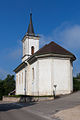
Saint-Germain et Protais church

school


Personalities
- Remi, artist and musician
Web links
- Réclère (French)
- Grottes de Réclère (French)
- Dominique Prongué: Réclère. In: Historical Lexicon of Switzerland .
Individual evidence
- ↑ Andres Kristol / Nicolas Pépin, Réclère JU (Porrentruy) in: Dictionnaire toponymique des communes suisses - Lexicon of Swiss community names - Dizionario toponomastico dei comuni svizzeri (DTS | LSG) , Center de dialectologie, Université de Neuchâtel, Verlag Huber, Frauenfeld / Stuttgart / Vienna 2005, ISBN 3-7193-1308-5 and Éditions Payot, Lausanne 2005, ISBN 2-601-03336-3 , p. 729f.
All | La Baroche | Basse-Allaine | Beurnevésin | Boncourt | Bonfol | Bure | Clos du Doubs | Coeuve | Cornol | Courchavon | Courgenay | Courtedoux | Damphreux | Fahy | Fontenais | Grandfontaine | Haute-Ajoie | Lugnez | Porrentruy | Vendlincourt
Former parishes: Asuel | Bressaucourt | Buix | Charmoille | Chevenez | Courtemaîche | Damvant | Fregiécourt | Miécourt | Montenol | Montignez | Montmelon | Montvoie | Ocourt | Pleujouse | Réclère | Roche-d'Or | Rocourt | Seleute | Saint-Ursanne
Canton of Jura | Districts of the Canton of Jura | Municipalities of the Canton of Jura