Plöckenstein
| Plöckenstein / Plechý | ||
|---|---|---|
|
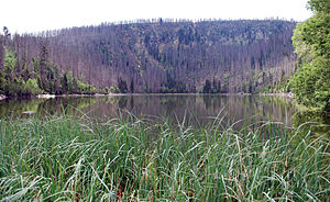
View to the summit from the north ( Plöckensteinsee ) |
||
| height | 1379 m above sea level A. ( 1378.3 m nm ) | |
| location | Upper Austria , Austria and South Bohemian Region , Czech Republic | |
| Mountains | Bohemian forest | |
| Dominance | 42.2 km → Big Rachel | |
| Notch height | 511 m ↓ Frauenberg | |
| Coordinates | 48 ° 46 '16 " N , 13 ° 51' 26" E | |
|
|
||
| rock | Eisgarner granite | |
|
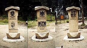
Austrian - Czech border on the |
||
The Plöckenstein ( Czech Plechý ) is a 1379 m above sea level. A. high mountain in the Bohemian Forest on the Austrian - Czech border. Its summit is the highest point in the Bohemian Forest in both countries, as well as the highest point in the Mühlviertel and southern Bohemia . He is known from the stories of Adalbert Stifter .
Geographical location
The Plöckenstein lies between the Austrian municipality of Schwarzenberg in the south and the Czech municipality of Nová Pec in the northeast. To the northeast, a little below the summit, lies the Plöckensteiner See in the Czech Republic , the southernmost of eight glacial lakes in the Bohemian Forest; the northern mountain flank is the core zone of the Czech National Park Šumava . The Jezerní potok ( Seebach ) rises on the mountain . The western end of the lip reservoir extends about 7 km to the northeast in the Czech Republic .
Dreiländereck and extreme point
The Plöckenstein is about 1.3 km east of the border triangle Germany - Austria - Czech Republic . There the border between Germany and the Czech Republic , the border between Germany and Austria and the border between Austria and the Czech Republic have a common point. The triangle is located a little east of the 1365 m above sea level. NHN high Bavarian Plöckenstein . The area of the triangle is also called Dreiecksmark ( Trojmezí ) and is 1321 m above sea level. NHN high mountain saddle that connects both "Plöckensteine".
In addition, the northernmost point of Upper Austria is just west of the Plöckenstein.
Attractions
During the Cold War , the border area of the Bohemian Forest was inaccessible to the Eastern European citizens; the iron curtain ran there . The new government that took office on December 10, 1989 under Marián Čalfa had the CSSR's border fortifications to the west dismantled in December 1989 (see also Velvet Revolution ).
The sights and excursion destinations in the vicinity of the Plöckenstein include (sorted alphabetically):
- Adalbert Stifter Monument ( 1311 m nm ; Czech Republic) - From 1876 to 1877 a 14.5 m high obelisk was built in memory of Adalbert Stifter (“Poet of the Bohemian Forest”) on a rock face above the Plöckensteinsee .
- Dreisesselberg ( 1333 m above sea level ; Germany) - From the granite rocks of this mountain, weathered into pillow-like shapes, the view extends to the Alps on a clear day .
- Plöckensteinsee ( 1090 m nm ; Czech Republic) - This approximately 7.48 hectare mountain lake is located below the Plöckenstein.
- Schwarzenbergscher Schwemmkanal (Austria-Czech Republic) - This is an artificially created canal that overcomes the watershed between the Vltava and the Danube .
- Lips reservoir (also called Moldaustausee ; 725.6 m nm ; Czech Republic) - The reservoir is around 48 km long, has an area of 48.7 km² and 309.5 million m³ of storage space.
- Steinernes Meer at the Bavarian Plöckenstein ( 1365 m above sea level ; Germany) - rocky landscape on the southern flank of the German-Czech border mountain
- Teufelsschüssel ( 1108 m above sea level ; Austria) - granite block formation a little east of the German-Austrian border
panorama


