Ullersbach (Lusatian Neisse)
|
Oldřichovský potok / Lubota Ullersbach, Ullersdorfer Bach |
||
|
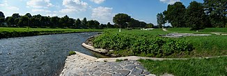
Dreiländereck at the confluence of the Ullersbach in the Neisse |
||
| Data | ||
| Water code | CZ : 2-04-07-038 | |
| location | Czech Republic , Poland | |
| River system | Or | |
| Drain over | Lusatian Neisse → Oder → Baltic Sea | |
| source | northeast of Hrádek nad Nisou on the Zlatá výšina 50 ° 51 '46 " N , 14 ° 52' 19" O |
|
| Source height | 280 m nm | |
| muzzle | at the border triangle in the Lausitz Neisse Coordinates: 50 ° 52 '14 " N , 14 ° 49' 25" E 50 ° 52 '14 " N , 14 ° 49' 25" E |
|
| Mouth height | 235 m nm | |
| Height difference | 45 m | |
| Bottom slope | 9.6 ‰ | |
| length | 4.7 km | |
| Catchment area | 6.15 km² | |
The Ullersbach , also Ullersdorfer Bach (Czech Oldřichovský potok , Polish Lubota ) is a right tributary of the Lusatian Neisse in the Czech Republic . At a length of 3.48 kilometers, the small stream forms the border between Poland and the Czech Republic.
course
The Oldřichovský potok rises northeast of Hrádek nad Nisou on the Zlatá výšina ( Golden Height ) in the Grottau Basin ( Hrádecká pánev ) and flows in its upper reaches through a wooded ground with a north-westerly direction to Oldřichov na Hranicích . There the stream takes a westerly direction and forms the Czech - Polish state border, which separates Oldřichov na Hranicích from the Polish villages of Kopaczów and Luptin . North of Hrádek nad Nisou the Ullersbach is from the new highway I / 35 between Chrastava and Zittau , and the railway line Liberec-Zittau bridged. On the left side of the lower course is the customs house on the old road between Hrádek nad Nisou and Zittau, as well as the silted residual hole of the new Důl Kristina mine, which was operated between 1957 and 1972 . After almost five kilometers, the Ullersbach flows northwest of Hrádek nad Nisou into the Lusatian Neisse . Its confluence between Zittau, Hrádek nad Nisou and Hartau forms the triangle between Germany , Poland and the Czech Republic.
The Ullersbach has no notable tributaries.
history
Grenzbach
In the fragmented village of Ullersdorf for a long time there was no clear boundary between the shares of the Grafenstein and Seidenberg rulers and later Reibersdorf . The parcels of the elongated Waldhufendorf belonged strongly mixed to this or that rule. With the transition of Upper Lusatia to Kursachsen , the new situation arose from 1635, the division of the place into a Saxon and a Bohemian part, whereby the unmanageable borders in Ullersdorf continued to exist.
With the border and territorial recession between the Kingdom of Saxony and the Empire of Austria , which was concluded on March 5, 1848, and which included the equalization of the various enclaves and exclaves of both states and was implemented on March 12, 1849, a clear boundary line arose between the two states. The course of the Ullersbach in Niederdorf was defined as the border between the Bohemian Ullersdorf and the Saxon Oberullersdorf .
With the establishment of the Oder-Neisse line as the eastern border of Germany, the Ullersbach became the border stream between Czechoslovakia and Poland after the end of the Second World War .
Tri-border region
After the founding of the German Democratic Republic , the mouth of the Ullersdorfer Bach formed the triangle between the GDR, the People's Republic of Poland and Czechoslovakia . However, the border point remained a secluded place; There were no border crossings between the three states in the vicinity.
After the fall of the Wall, the triangle between Poland, Czechoslovakia and Germany experienced a political upgrade. At the beginning of May 2004, on the occasion of the central German, Czech and Polish celebration of the EU's eastward expansion in Zittau, a ceremony took place at the border triangle, for which a temporary bridge was built over the Neisse. After the temporary bridge was dismantled and the dilapidated sky bridge was torn down, the three-country corner fell back into its seclusion. A pedestrian bridge project at the border triangle has existed since 2006 and has not yet been implemented.
See also
Individual evidence
- ↑ https://is.muni.cz/th/222783/prif_m/DP_Musilova.txt?studium=282101;vysl=19055
- ↑ https://is.muni.cz/th/222783/prif_m/DP_Musilova.txt?studium=282101;vysl=19055
- ↑ (see archived copy ( memento of the original dated November 16, 2013 in the Internet Archive ) Info: The archive link has been inserted automatically and has not yet been checked. Please check the original and archive link according to the instructions and then remove this note. )


