
Garbolc
| Garbolc | |||||
|
|||||
| Basic data | |||||
|---|---|---|---|---|---|
| State : | Hungary | ||||
| Region : | Northern Great Plain | ||||
| County : | Szabolcs-Szatmár-Bereg | ||||
| Small area until December 31, 2012 : | Fehérgyarmat | ||||
| District since 1.1.2013 : | Fehérgyarmat | ||||
| Coordinates : | 47 ° 57 ' N , 22 ° 52' E | ||||
| Area : | 7.25 km² | ||||
| Residents : | 150 (Jan. 1, 2011) | ||||
| Population density : | 21 inhabitants per km² | ||||
| Telephone code : | (+36) 44 | ||||
| Postal code : | 4976 | ||||
| KSH kódja: | 04996 | ||||
| Structure and administration (as of 2020) | |||||
| Community type : | local community | ||||
| Mayor : | Roland Nagy (Fidesz-KDNP) | ||||
| Postal address : | Rákóczi Ferenc u. 46 4976 Garbolc |
||||
| (Source: A Magyar Köztársaság helységnévkönyve 2011. január 1st at Központi statisztikai hivatal ) | |||||


Garbolc is a Hungarian community in the district Fehérgyarmat in Szabolcs-Szatmár-Bereg County .
Geographical location
Garbolc is located in the border triangle Romania , Ukraine and Hungary, one kilometer south of the river Túr . Hungarian neighboring communities are Méhtelek and Nagyhódos . Bercu is located four kilometers southeast of the Romanian border .
Attractions
- Memorial column at the easternmost point of Hungary ( Magyarország legkeletibb pontja emlékoszlop )
- Nature trail Keletpont tanösvény
- Garbolci erdő nature reserve
- Reformed Church, built between 1844 and 1888
- Roman Catholic Chapel Szent József , next to the church there is a bell tower
- Traditional house ( Népi lakóház )
traffic
Road No. 4143 runs through Garbolc, from which the secondary road No. 41134 branches off and heads south to the Garbolc-Bercu border crossing . The nearest Hungarian railway station is seven kilometers south-west in Rozsály , the nearest Romanian train station south-east in Micula .
photos
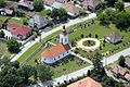
View of the reformed church

The river Túr in winter
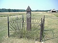
The easternmost point of Hungary near Garbolc

.jpg)

See also
Web links
- Garbolc bei Szatmár Tour (Hungarian)