
Túristvándi
| Túristvándi | |||||
|
|||||
| Basic data | |||||
|---|---|---|---|---|---|
| State : | Hungary | ||||
| Region : | Northern Great Plain | ||||
| County : | Szabolcs-Szatmár-Bereg | ||||
| Small area until December 31, 2012 : | Fehérgyarmat | ||||
| District since 1.1.2013 : | Fehérgyarmat | ||||
| Coordinates : | 48 ° 3 ' N , 22 ° 39' E | ||||
| Area : | 15.22 km² | ||||
| Residents : | 680 (Jan. 1, 2011) | ||||
| Population density : | 45 inhabitants per km² | ||||
| Telephone code : | (+36) 44 | ||||
| Postal code : | 4944 | ||||
| KSH kódja: | 13602 | ||||
| Structure and administration (status: 2018) | |||||
| Community type : | local community | ||||
| Mayor : | Tibor Lakatos (Fidesz-KDNP) | ||||
| Postal address : | Móricz Zsigmond u. 23 4944 Túristvándi |
||||
| (Source: A Magyar Köztársaság helységnévkönyve 2011. január 1st at Központi statisztikai hivatal ) | |||||


Túristvándi (formerly Istvándi ) is a Hungarian community in the district Fehérgyarmat in Szabolcs-Szatmár-Bereg County .
Location and traffic
Túristvándi is a good 12 kilometers northeast of the town of Fehérgyarmat on the Túr River and about four kilometers south of the Tisza , which forms the border with Ukraine . Neighboring communities are Szatmárcseke , Kömörő and Tiszakóród .
Road no. 4129 runs through Túristvándi. The nearest train station is to the southwest in Penyige .
Attractions
- Watermill ( vízimalom ), built at the end of the 18th century, with three overshot water wheels
- Recreation park ( Pihenőpark )
- Kölcsey-Landhaus ( Kölcsey-kúria )
- Reformed Church
- Szűz Mária Istenanya Roman Catholic Chapel , built in 1821
- World War Memorial ( Világháborús emlékmű )
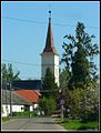
reformed Church
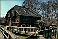
Watermill
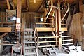
Interior of the watermill
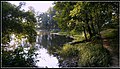
The river Túr
.jpg)


.jpg)
Web links
- Túristvándi bei Szatmár Tour ( Hungarian )
- Túristvándi (Hungarian)
- Túristvándi község címere (Hungarian)