
Abbévillers
| Abbévillers | ||
|---|---|---|
.svg)
|
|
|
| region | Bourgogne-Franche-Comté | |
| Department | Doubs | |
| Arrondissement | Montbeliard | |
| Canton | Maîche | |
| Community association | Pays de Montbéliard agglomeration | |
| Coordinates | 47 ° 26 ' N , 6 ° 55' E | |
| height | 427-612 m | |
| surface | 11.18 km 2 | |
| Residents | 1,040 (January 1, 2017) | |
| Population density | 93 inhabitants / km 2 | |
| Post Code | 25310 | |
| INSEE code | 25004 | |
| Website | www.abbevillers.fr | |

Abbévillers is a French commune with 1,040 inhabitants (as of January 1 2017) in Doubs in the region Bourgogne Franche-Comté .
geography
Abbévillers is located at 575 m, about 13 kilometers southeast of the city of Montbéliard (as the crow flies ). The village extends in the northern Jura , on the wide plateau of the Table Jura east of the valley section of the Gland , near the border with Switzerland .
The area of the 11.18 km² large municipality covers a section of the northern French Jura. The main part of the area is occupied by the slightly undulating Tafeljura plateau, consisting of Sequan and Kimmeridge limestone, which averages at 560 to 580 m. Some heights reach just over 600 m, including Sur le Seux , La Craye and Les Hautes Bornes , which at 612 m is the highest point in Abbévillers. The high plateau is mainly made up of arable and meadow land, but also shows some forest areas. There are no surface rivers here because the rainwater seeps into the karstified subsoil. To the east, the high plateau merges into the Fahy plateau (Switzerland).
In the peripheral areas Abbévillers has a share of erosion valleys that lead down to the surrounding valley systems. To the southeast, the municipality extends into the wooded section of the Combotte Roussot , which with its side valleys (including the Combe aux Enfers ) is cut almost 100 meters into the plateau. The southern border runs at the karst spring of the Doue, which feeds its water into the gland.
In addition to the actual village, Abbévillers also includes the hamlet of La Chaifferie (569 m) on the edge of the Fahy plateau as well as several farms and individual farms. Neighboring communities of Abbévillers are Glay and Meslières in the southwest, Hérimoncourt in the west, Vandoncourt in the north, Croix in the northeast and the Swiss communities Fahy in the east and Grandfontaine in the south.
history
Abbévillers was first mentioned in a document in 1140 under the name Albervillers . Over time, the spelling changed via Albervillars (1147), Albrechzviler (1300), Azberveler (1306), Aubeveler (1331), Abeviler (1443) and Abelviller (1480) to the current name.
Since the Middle Ages Abbévillers belonged to a local noble family who owned a castle here and acted as vassals of the Counts of Montbéliard. Abbévillers came through the Lords of Rocourt, Rieschach and Wandelincourt in 1579 under the direct influence of the Counts of Montbéliard. In the following period, the village was badly affected by the invasion of the Guisen (1587) and in the Thirty Years' War . With the annexation of the county of Württemberg-Mömpelgard (Montbéliard) , the village finally came into French hands in 1793. In the 19th century, a file factory and a brick factory settled in Abbévillers, but the village always remained predominantly agricultural. Abbévillers has been part of the Pays de Montbéliard Agglomération community association since 2017 .
population
With 1040 inhabitants (as of January 1, 2017) Abbévillers is one of the small communities in the Doubs department. After the population had decreased slightly in the first half of the 20th century (in 1901 there were still 485 people), a marked increase in population has been recorded since the early 1960s. Since then the number of inhabitants has almost tripled.
| Population development | ||||||||
|---|---|---|---|---|---|---|---|---|
| year | 1962 | 1968 | 1975 | 1982 | 1990 | 1999 | 2009 | 2016 |
| Residents | 342 | 405 | 570 | 760 | 817 | 877 | 1055 | 1031 |
Attractions
The Abbévillers Lutheran Church (Temple luthérien) was rebuilt from 1850 to 1853 on the site of a 17th century church. The Mairie (town hall) dates from 1877 .

Lutheran Church

Mairie and Post
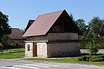
Stone oven bakery


Economy and Infrastructure
Abbévillers was a village dominated by agriculture (arable farming, fruit growing and cattle breeding) well into the 20th century. In addition, there are now some local small businesses. In the meantime, the village has turned into a residential community thanks to its attractive location. Many workers are therefore commuters who do their work in the Montbéliard agglomeration.
The village is well developed in terms of traffic. It lies on the department road D 34 from Audincourt to Porrentruy leads. The closest connection to the A 36 motorway is around 14 km away. Other road connections exist with Croix, Montbouton and Meslières.
Web links
Individual evidence
- ↑ See "Abbévillers: le temple luthérien", on: Les temples ou églises luthériennes de France - [Recherche alphabétique: A], accessed on January 23, 2016.