Étouvans
| Étouvans | ||
|---|---|---|

|
|
|
| region | Bourgogne-Franche-Comté | |
| Department | Doubs | |
| Arrondissement | Montbeliard | |
| Canton | Bavans | |
| Community association | Pays de Montbéliard agglomeration | |
| Coordinates | 47 ° 28 ' N , 6 ° 43' E | |
| height | 301-476 m | |
| surface | 6.56 km 2 | |
| Residents | 825 (January 1, 2017) | |
| Population density | 126 inhabitants / km 2 | |
| Post Code | 25260 | |
| INSEE code | 25224 | |
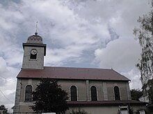
 Mairie Etouvans |
||
Etouvans is a French municipality with 825 inhabitants (as of January 1 2017) in Doubs in the region Bourgogne Franche-Comté .
geography
Étouvans is located at 360 m , about eight kilometers southwest of the city of Montbéliard (as the crow flies). The village extends in a hollow south of the Doubstal , on the northern edge of the extreme ridges of the Jura .
The area of the 6.56 km² municipal area includes a section of the Doubstal. The northern border runs along the Doubs, which flows here in a flat valley low about 1.5 kilometers to the southwest and is accompanied by the waterway of the Rhine-Rhône Canal . From the course of the river, the community area extends southwards over the valley floodplain and a steep slope to the adjacent plateau, which is approximately 350 m. This plateau forms the main settlement area, in particular the depression between the hill of Étouvans ( 405 m ) and the plateau. To the south, a step of about 50 to 80 m in height leads over to the Tafeljura plateau . Here, at 476 m, the highest elevation of Étouvans is reached. The high plateau is partly covered by arable land and meadows, but also shows some larger forest areas ( Bois de Charmes and Bois des Murgers ). The western boundary runs in the erosion valley of the Combe d'Étouvans .
The settlement of La Raydans ( 310 m ) on the southern edge of the Doubs valley plain belongs to Étouvans . Neighboring municipalities of Étouvans are Bavans in the north, Dampierre-sur-le-Doubs in the east, Écot and Villars-sous-Écot in the south and Colombier-Fontaine in the west.
history
The place name ending "-ans" indicates that Étouvans has been inhabited since the time of the Burgundians (6th century). The village was first mentioned in 1181 under the name Estovans . In the Middle Ages, two thirds of the village belonged to the lordship of Dampierre-sur-le-Doubs under the suzerainty of the Lords of Neuchâtel , while the rest was under the suzerainty of the Counts of Württemberg-Mömpelgard (Montbéliard) . With the Peace of Nijmegen , that part of the Dampierre-sur-le-Doubs dominion came to France in 1678. This led to the division of the municipality, as the rest remained with the county of Montbéliard. It was not until this county was incorporated into the French Republic that Étouvans was reunited in 1793. Today, Étouvans is part of the Pays de Montbéliard Agglomération municipal association .
Attractions
The church of Saint-Ferréol-et-Ferjeux was built between 1842 and 1847 in the neo-Romanesque style and has a remarkable altar from the 17th century, which was transferred here from the chapel of a castle near Cubrial (near Rougemont). The rectory dates from 1860.
population
| Population development | |
|---|---|
| year | Residents |
| 1962 | 563 |
| 1968 | 624 |
| 1975 | 746 |
| 1982 | 891 |
| 1990 | 760 |
| 1999 | 721 |
| 2006 | 762 |
| 2016 | 822 |
With 825 inhabitants (as of January 1, 2017), Étouvans is one of the small communities in the Doubs department. After the population in the first half of the 20th century had always been in the range between 490 and 580 people, there has been significant population growth since the 1960s.
Economy and Infrastructure
Until the beginning of the 20th century, Étouvans was mainly characterized by agriculture (arable farming, fruit growing and cattle breeding) and forestry. In addition, there are now various local small businesses. In the meantime, the village has also turned into a residential community. Many workers are therefore commuters who work in the larger towns in the area and in the Montbéliard agglomeration.
The village is located away from the major thoroughfares on a departmental road that leads from Colombier-Fontaine to Dampierre-sur-le-Doubs. The closest connection to the A36 motorway is around nine kilometers away.
literature
- Le Patrimoine des Communes du Doubs. Volume 2, Flohic Editions, Paris 2001, ISBN 2-84234-087-6 , pp. 924-926.

